
On the Detection of Snow Cover Changes over the Australian Snowy Mountains Using a Dynamic OBIA Approach


Abstract
:1. Introduction
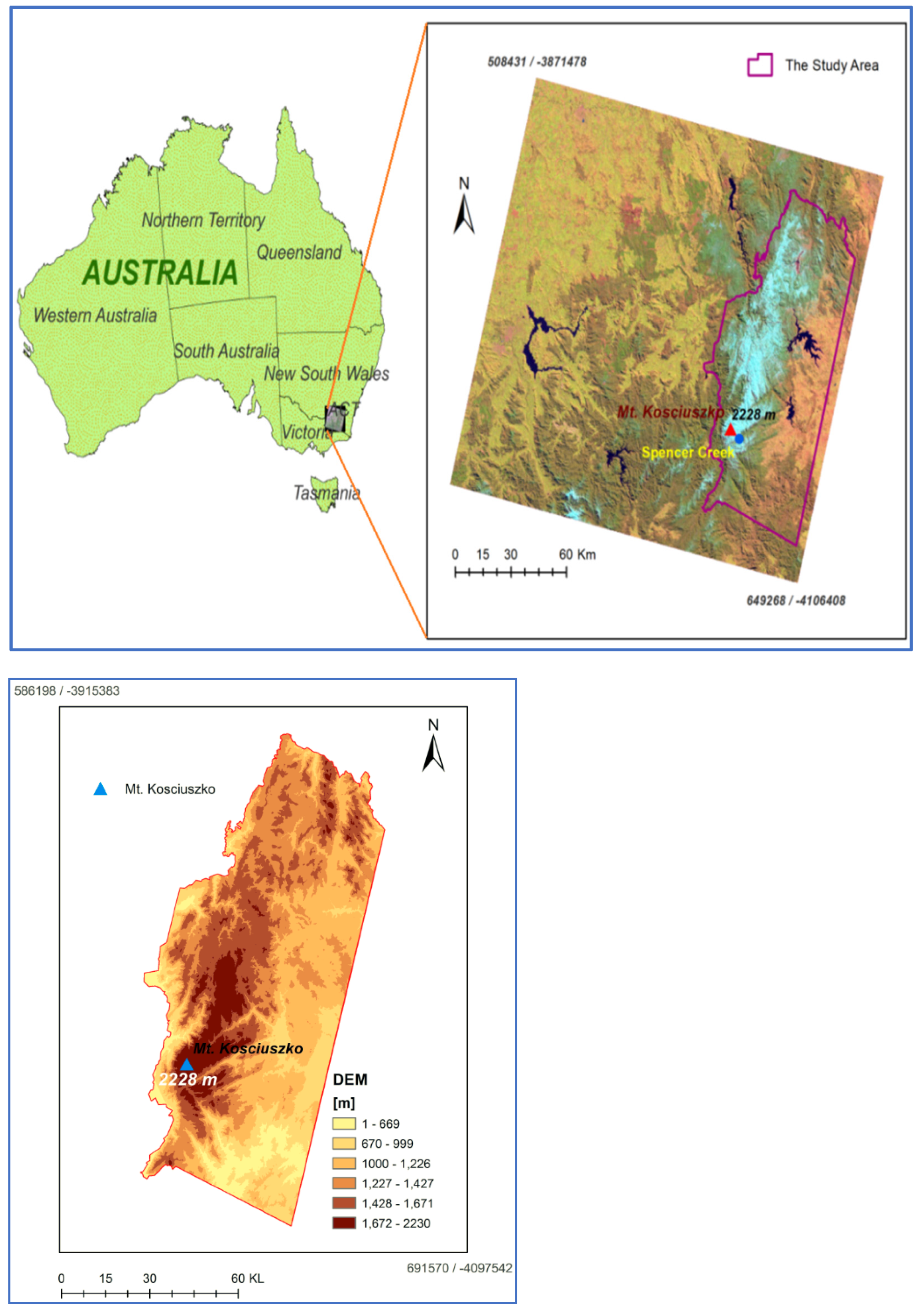
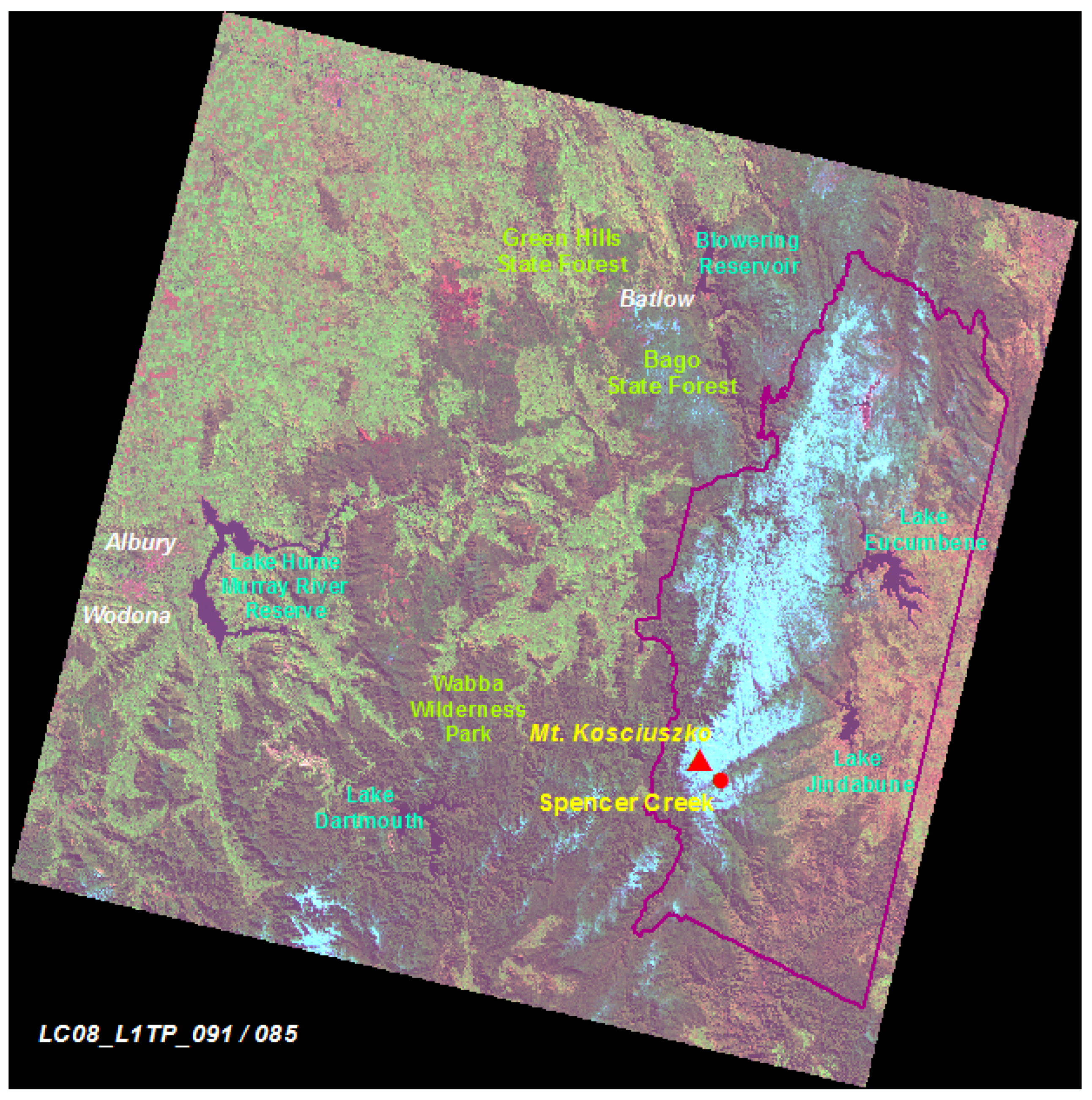
2. Study Area and Data
2.1. Study Area
2.2. Datasets Used
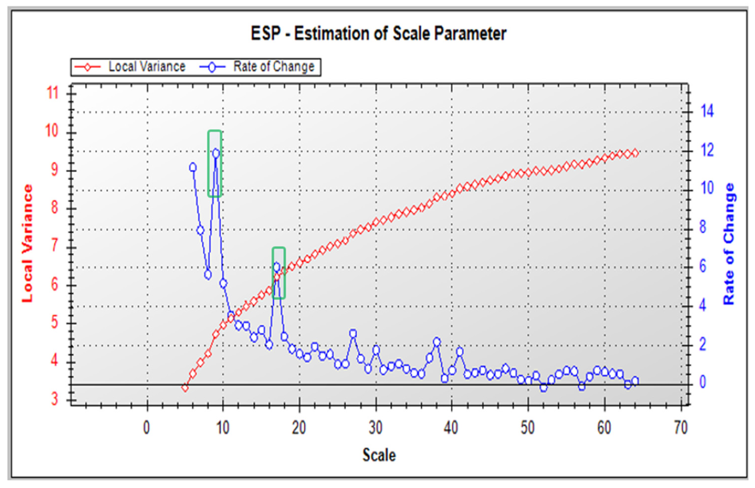
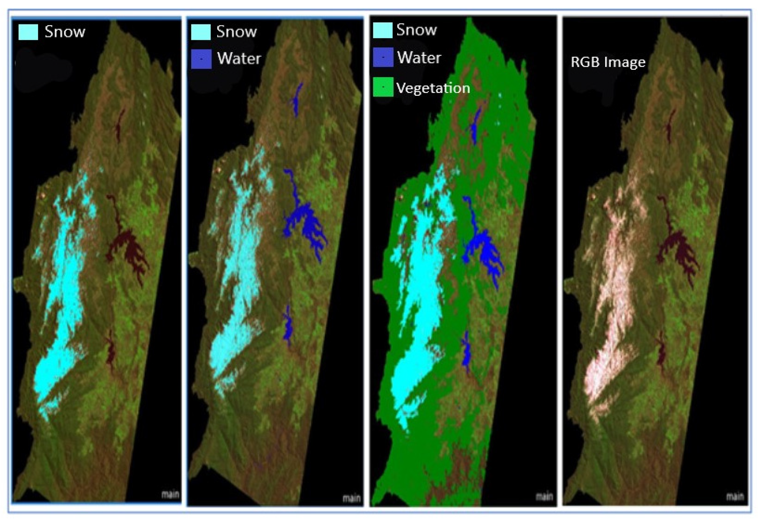
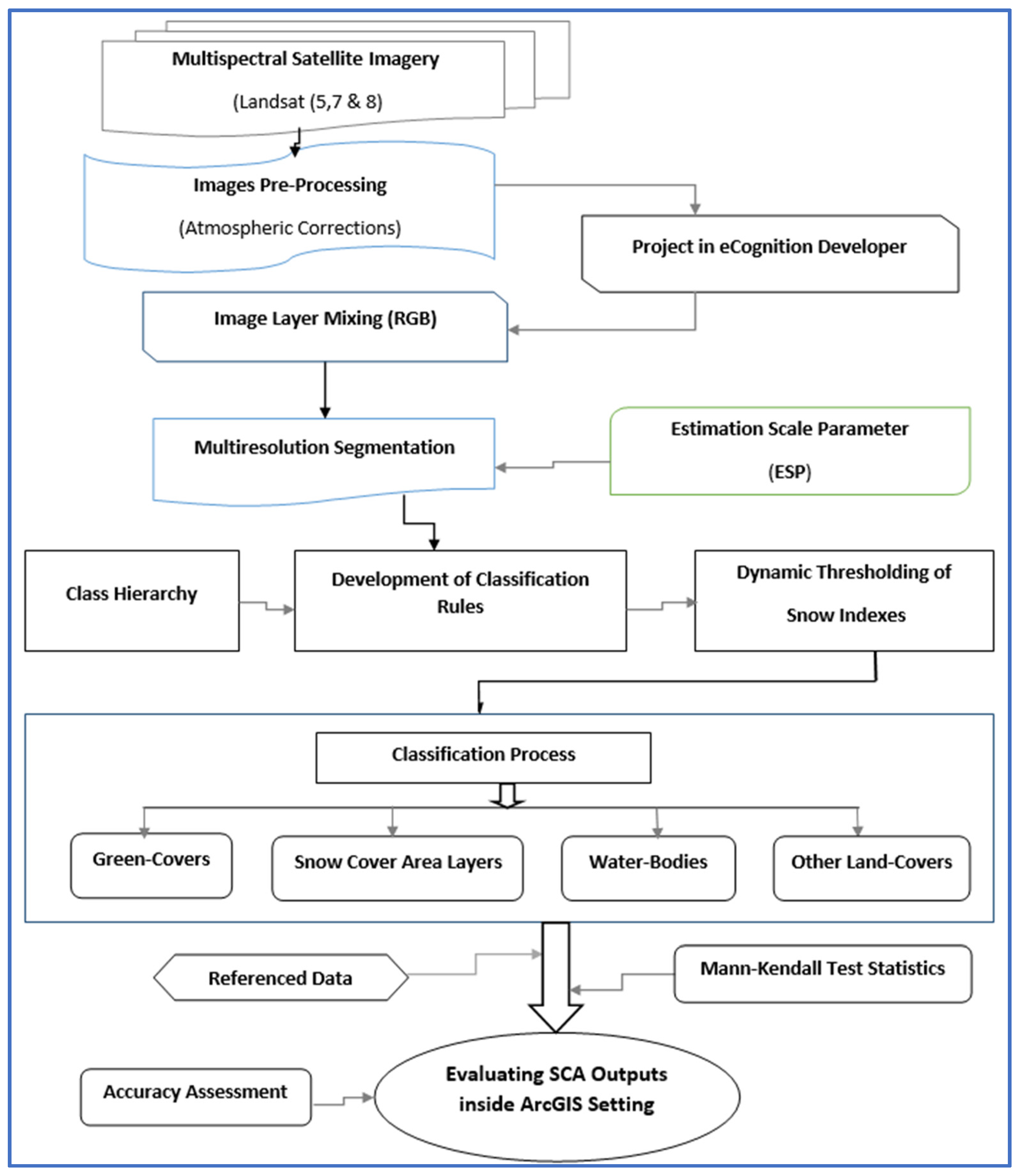
3. Methodology
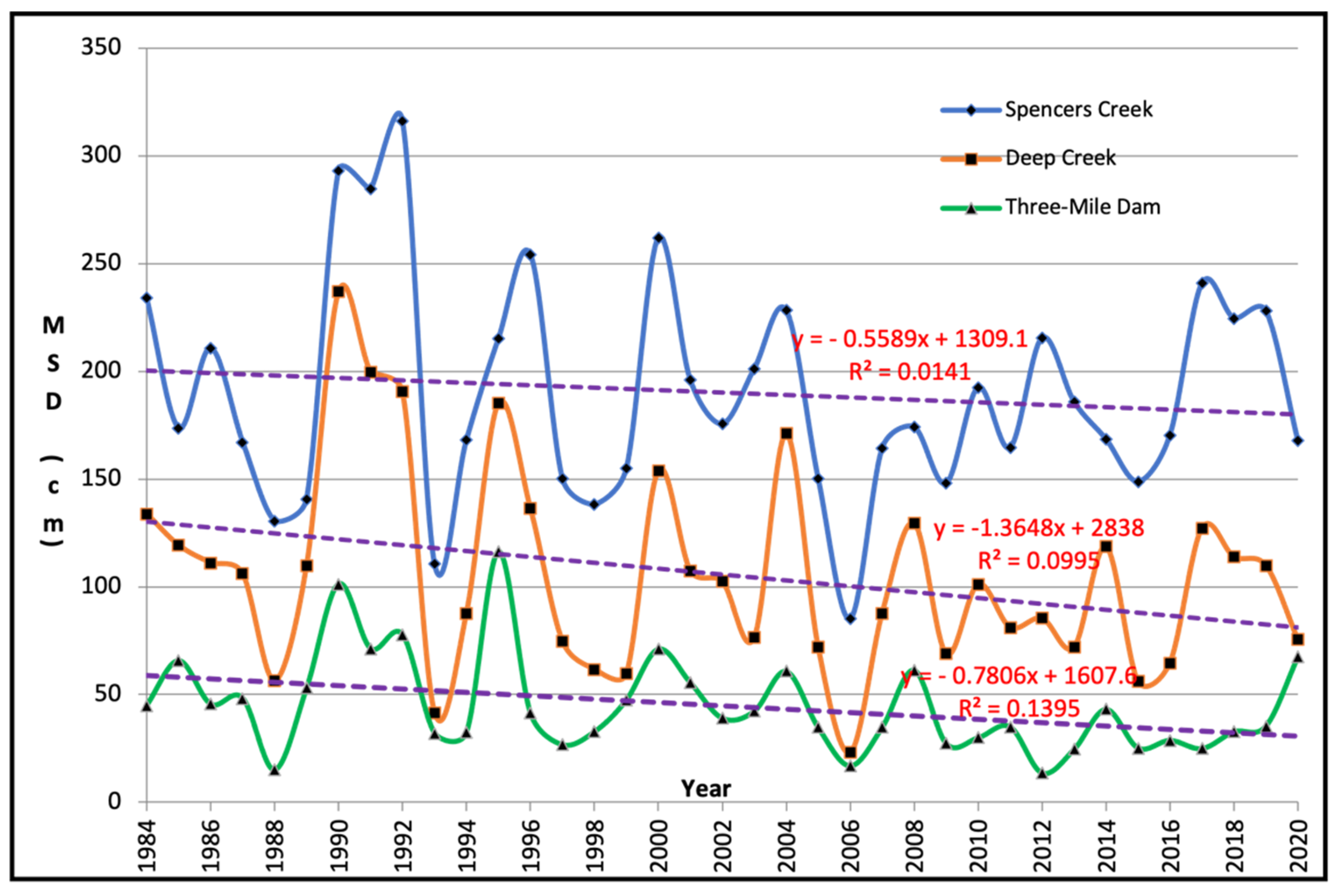
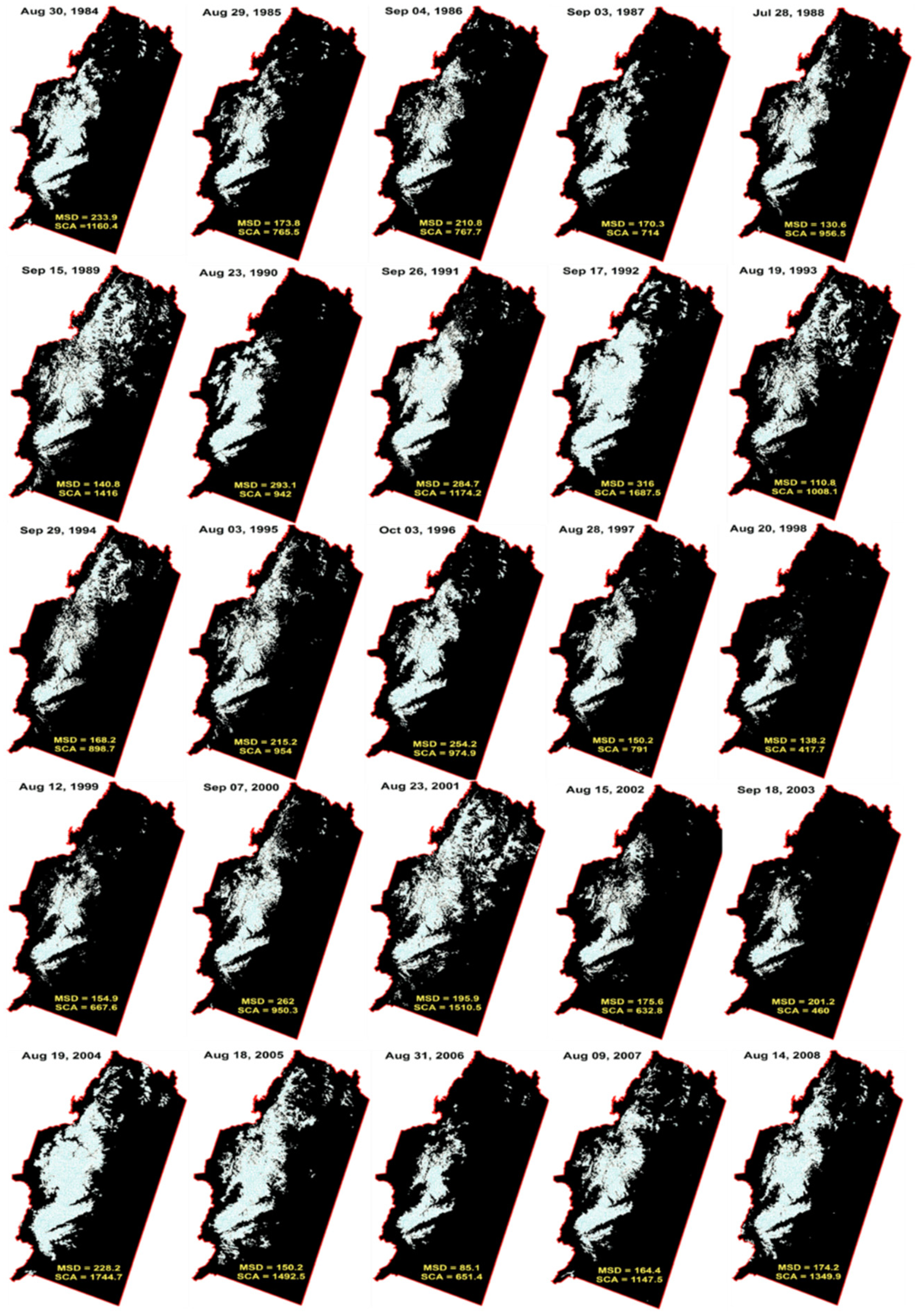
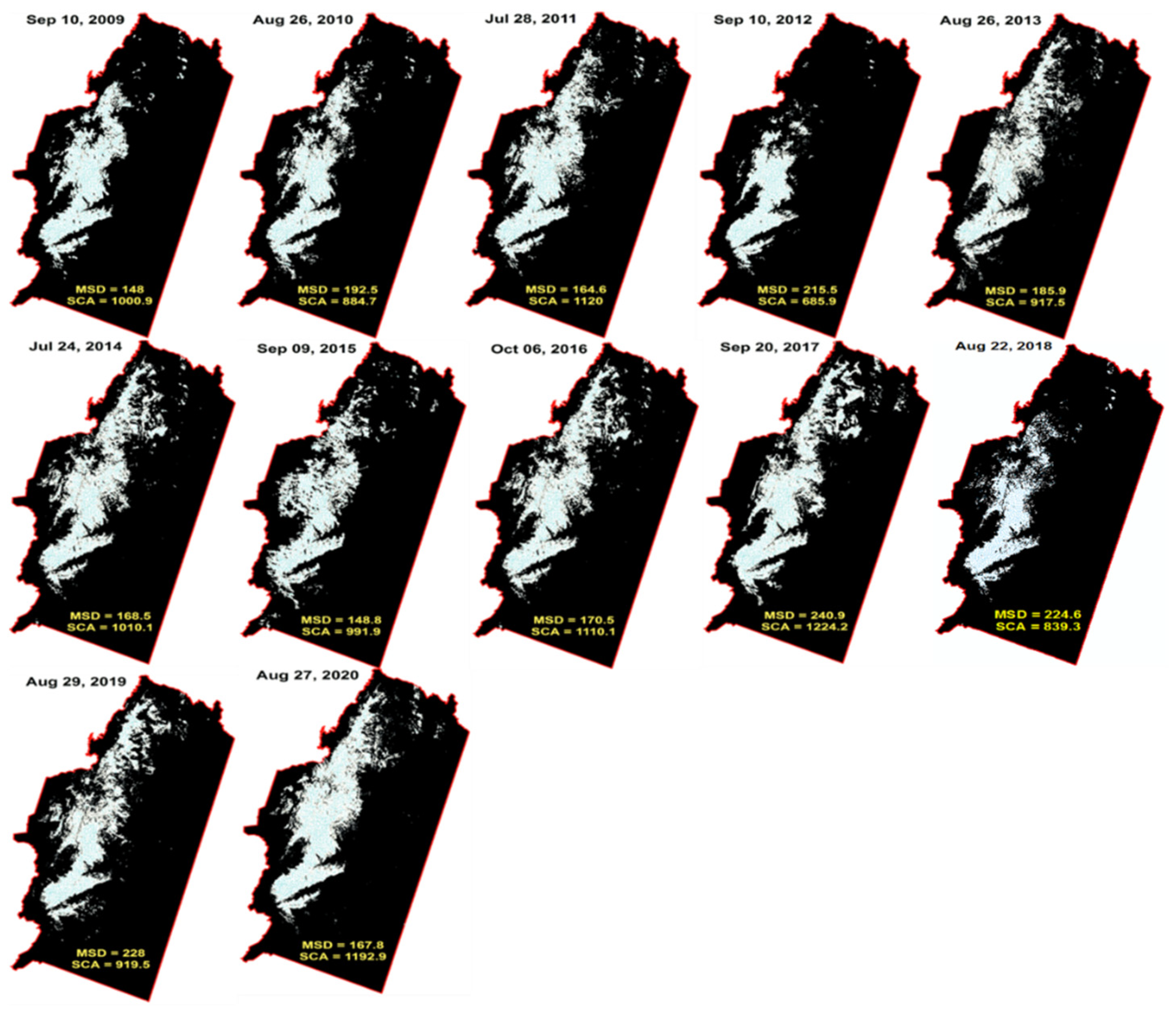
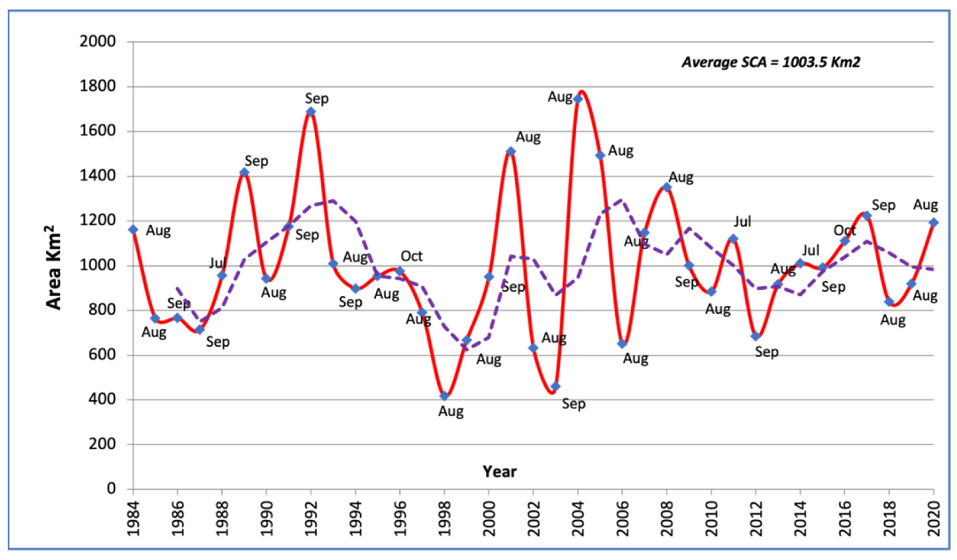
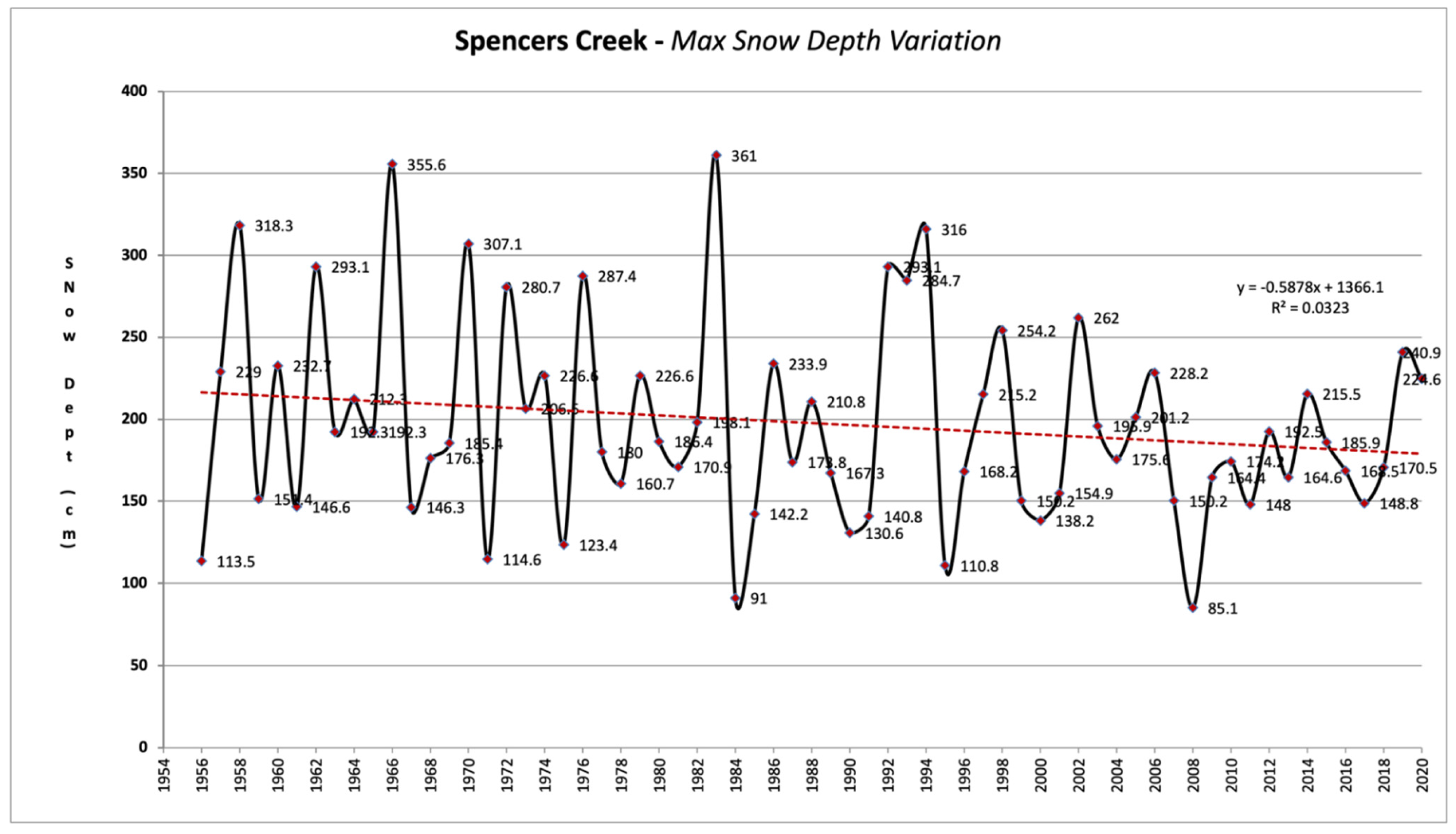
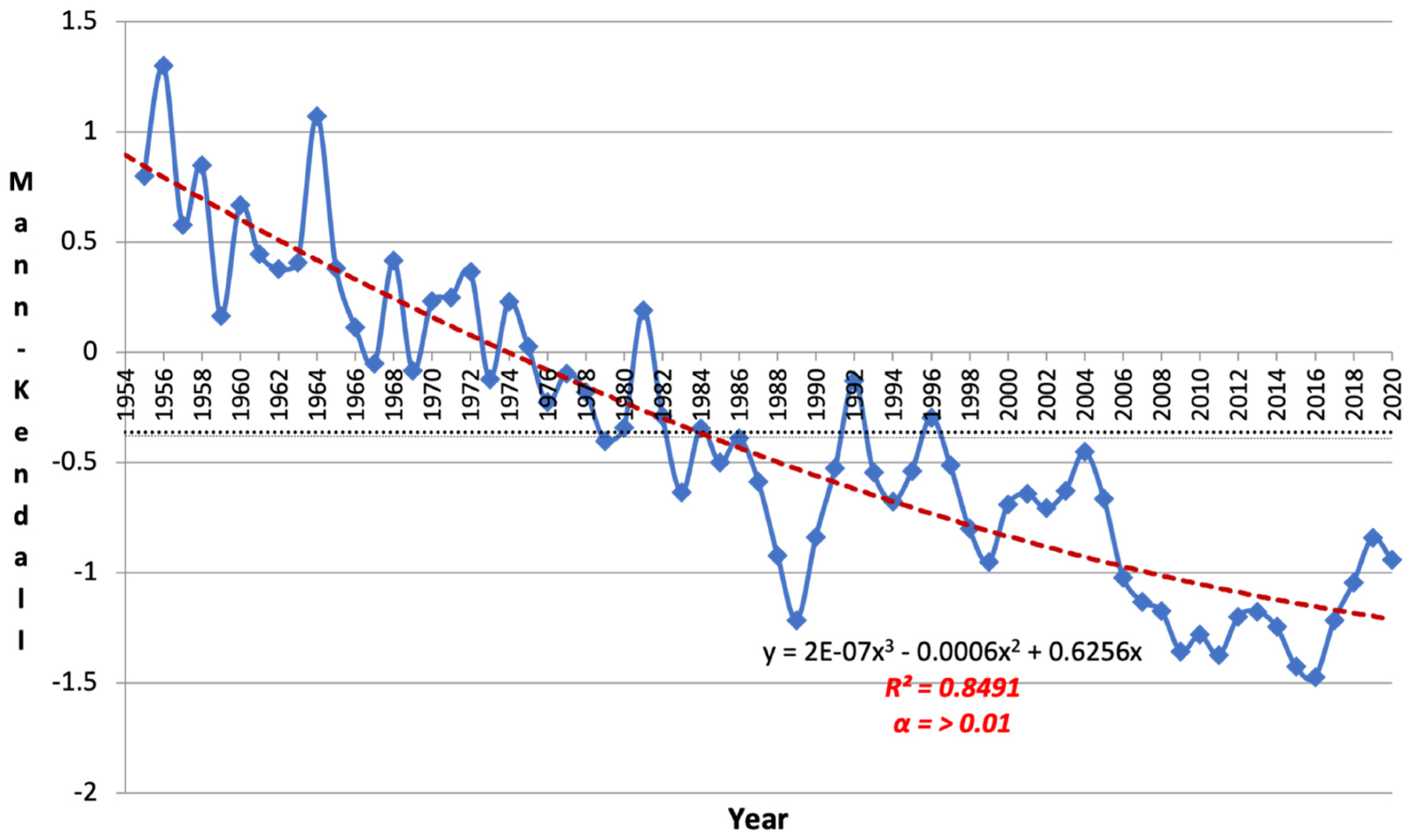
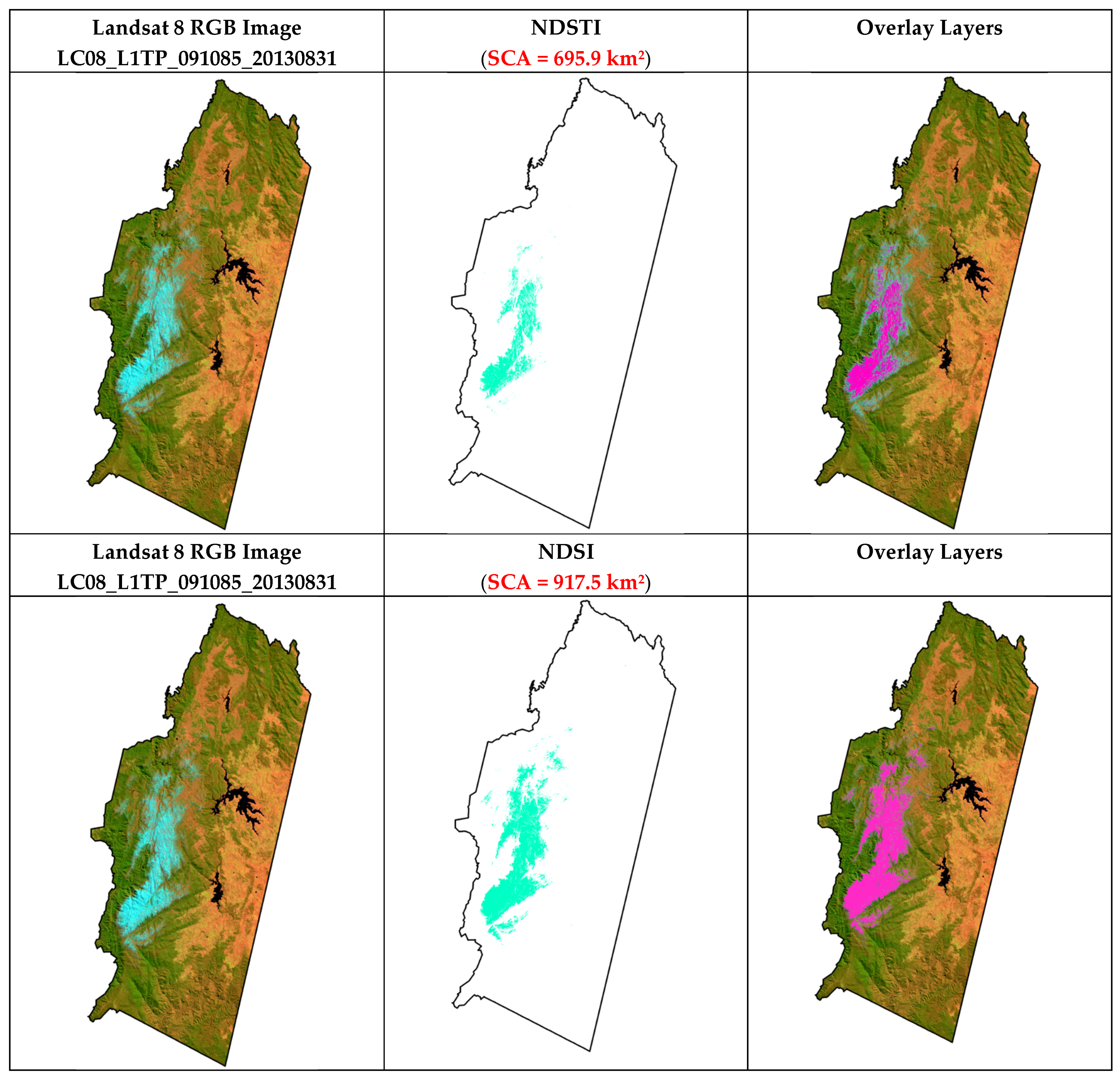
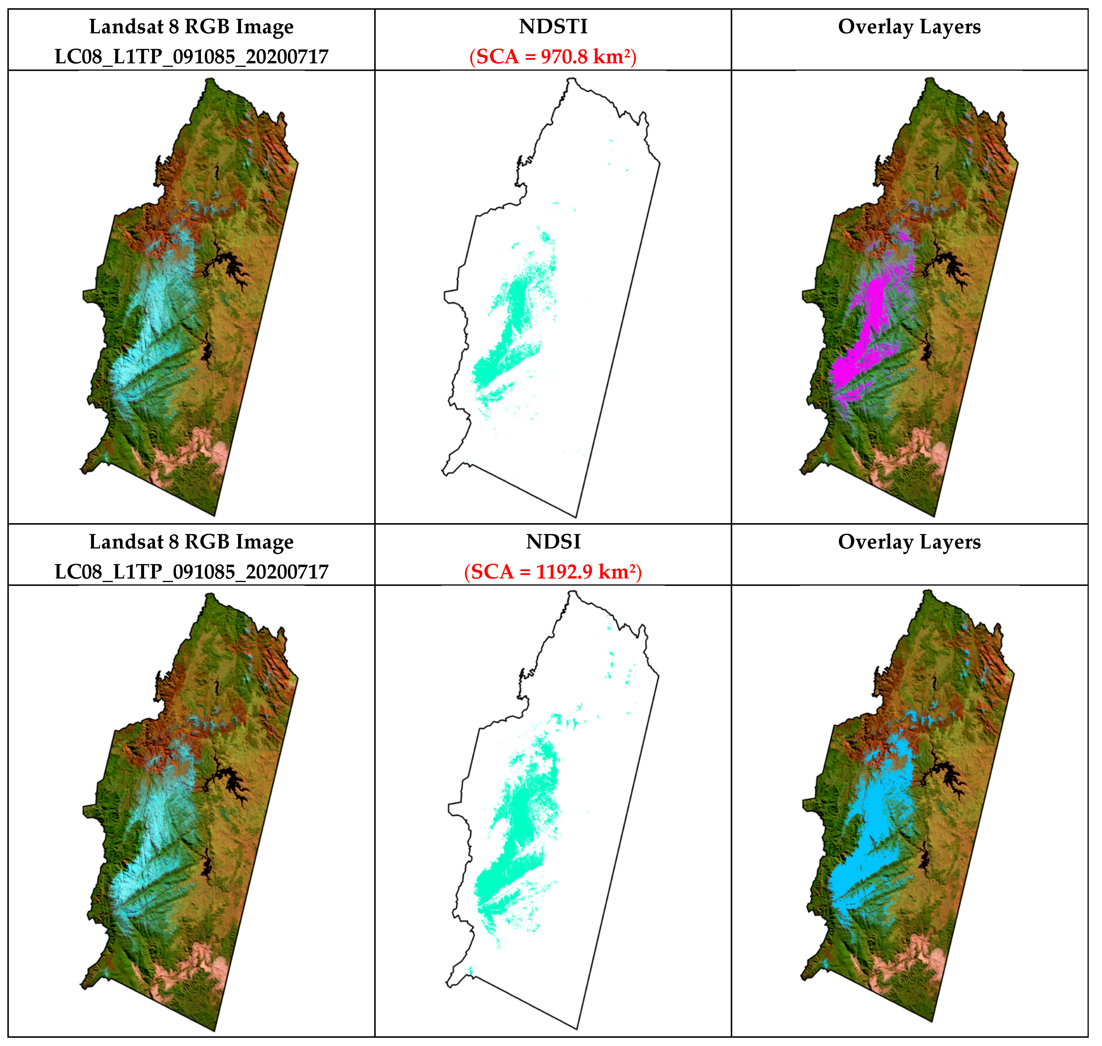
4. Results
5. Discussion
6. Conclusions
Author Contributions
Funding
Institutional Review Board Statement
Informed Consent Statement
Data Availability Statement
Acknowledgments
Conflicts of Interest
Appendix A

Appendix B


Appendix C
- Producer Accuracy is the map accuracy from the point of view of the mapmaker (the producer). It often refers to the real features on the ground correctly shown on the classified map or the probability that a certain land cover of an area is classified as such. The producer’s accuracy indicates the proportion of the reference data classified correctly for a given class.
- User Accuracy refers to how a classified map is real on the ground. The User Accuracy is the accuracy from the point of view of a map user, not the map maker. The User Accuracy essentially tells us how often the class on the map will be present on the ground.
- The “Hellden” Accuracy indicates the mean accuracy (developed by [98]). This index denotes the probability that a randomly chosen point of a specific class on the map corresponds to the same class in the same position in the field, and that a randomly chosen point in the field of the same class corresponds to the same class in the same position on the map.
- Another alternative index is the “Short” measure [98]. It can be interpreted as the ratio of the estimated and true classes’ intersection to their union in terms of set cardinality for a given class. It ranges from ‘no overlap’ to ‘complete overlap’.
- Kappa’s Coefficient of Agreement is a measure of accuracy for thematic classification, and the coefficient of conditional Kappa is an accuracy measure for the individual category [99]. A family of such coefficients is correct for chance agreement, but the Kappa coefficient is one of few defensible intraclass correlation coefficients. These coefficients use the classification error matrix information resulting from commission errors and omission.
Appendix D
Appendix E


References
- Yang, D.; Robinson, D.; Zhao, Y.; Estilow, T.; Ye, B. Stream-flow response to seasonal snow cover extent changes in large Siberian watersheds. J. Geophys. Res. 2003, 108. [Google Scholar] [CrossRef]
- Zhou, X.; Li, S. Comparison between in situ and MODIS-derived spectral reflectances of snow and sea ice in the Amundsen Sea, Antarctica. Int. J. Remote Sens. 2003, 24, 5011–5032. [Google Scholar] [CrossRef]
- Bonan, G. Ecological Climatology, Concepts and Applications; Cambridge University Press: New York, NY, USA, 2002. [Google Scholar]
- Tong, J.; Velicogna, I. A Comparison of AMSR-E/Aqua Snow Products with in situ Observations and MODIS Snow Cover Products in the Mackenzie River Basin. Can. Remote Sens. 2010, 2, 2313–2322. [Google Scholar] [CrossRef] [Green Version]
- Löffler, J. Snow cover dynamics, soil moisture variability and vegetation ecology in high mountain catchments of central Norway. Hydrol. Processes 2005, 19, 2385–2405. [Google Scholar] [CrossRef]
- Isard, S.A.; Schaetzl, R.J.; Andresen, J.A. Soils cool as the climate warms in the great lakes region: 1951–2000. Ann. Assoc. Amer. Geog. 2007, 97, 467–476. [Google Scholar] [CrossRef]
- Lu, S.; Oki, K.; Omasa, K. Mapping snow cover using AVHRR/NDVI 10-day composite data. J. Agric. Meteorol. 2005, 60, 1215–1218. [Google Scholar] [CrossRef] [Green Version]
- Kargel, J.S.; Abrams, M.J.; Bishop, M.P.; Bush, A.; Hamiton, G.; Jiskoot, H.A.; Kieffer, H.H.; Lee, E.M.; Paul, F.; Rau, F.; et al. Multispectral imaging contributions to global land ice measurements from space. Remote Sens. Environ. 2005, 99, 187–219. [Google Scholar] [CrossRef]
- Chinn, H.; Salinger, J.; Fitzharris, B.; Willsman, A. Glaciers and climate. Bull. Fed. Mt. Clubs N. Z. 2008, 171, 1–15. [Google Scholar]
- Luca, A.D.; Evans, J.P.; Ji, F. Australian snowpack in NARCliM ensemble: Evaluation, bias correction and future projections. Clim. Dyn. 2018, 51, 639–666. [Google Scholar] [CrossRef]
- Davis, C.J. Meteorological aspects of snow. In Snow: A Natural History, an Uncertain Future; Green, K., Ed.; Australian Alps Liaison Committee: Canberra, Australia, 1998; pp. 3–34. [Google Scholar]
- Ruddell, A.R.; Budd, W.F.; Smith, I.N.; Keage, P.L.; Jones, R. The South-East Australian Alpine Climate Study; Meteorology Department, University of Melbourne for the Alpine Resorts Commission: Melbourne, VIC, Australia, 1990; p. 115. [Google Scholar]
- Department of the Environment, Water, Heritage, and the Arts, Australia. The Snowy Mountains Scheme; Culture and recreation portal: Canberra, ACT, Australia, 2008. [Google Scholar]
- Snowy-Hydro, Annual Report. In Snowy Hydro Limited and Its Controlled Entities; Snowy Valleys Council: Khancoban, NSW, Australia, 2020.
- Brown, B.D.; Braaten, R.O. Spatial and temporal variability of Canadian monthly snow depths, 1946–1995. Atmos. Ocean 1998, 36, 37–54. [Google Scholar] [CrossRef]
- Kavzoglu, T.; Colkesen, I. A kernel functions analysis for support vector machines for land cover classification. Int. J. Appl. Earth Obs. Geoinfo. 2009, 11, 352–359. [Google Scholar] [CrossRef]
- Foody, G.M. Status of land cover classification accuracy assessment. Remote Sens. Environ. 2002, 80, 185–201. [Google Scholar] [CrossRef]
- Gillanders, S.N.; Coops, N.C.; Wulder, M.A.; Gergel, S.E.; Nelson, T. Multitemporal remote sensing of landscape dynamics and pattern change: Describing natural and anthropogenic trends. Prog. Phys. Geog. 2008, 32, 503–528. [Google Scholar] [CrossRef]
- Stroeve, J.; Box, E.; Gao, F.; Liang, S.; Nolin, A.; Schaaf, C. Accuracy assessment of the MODIS 16-day albedo product for snow: Comparisons with Greenland in situ measurements. Remote Sens. Environ. 2005, 94, 46–60. [Google Scholar] [CrossRef]
- Foster, J.L.; Hall, D.K.; Chang, Z. Remote sensing of snow. Eos Trans. Amer. Geophys. Union 1987, 68, 682–684. [Google Scholar] [CrossRef]
- Foody, G.M. Land cover classification by an artificial neural network with ancillary information. Int. J. Remote Sens. 1995, 16, 527–542. [Google Scholar] [CrossRef]
- Köning, M.; Winther, J.G.; Isaksson, E. Measuring snow and glacier ice properties from satellite. Rev. Geophys. 2001, 39, 1–27. [Google Scholar] [CrossRef]
- Foppa, N.; Stoffel, A.; Meister, R. Synergy of in situ and space-borne observation for snow depth mapping in the Swiss Alps. Int. J. Appl. Earth Obs. Geoinf. 2007, 9, 294–310. [Google Scholar] [CrossRef]
- Shreve, C.M.; Okin, G.S.; Painter, T.H. Indices for estimating fractional snow cover in the western Tibetan Plateau. J. Glaciol. 2009, 55, 737–745. [Google Scholar] [CrossRef] [Green Version]
- Zhou, C.; Zheng, L. Mapping radar glacier zones and dry snow line in the Antarctic peninsula using sentinel-1 images. Remote Sens. 2017, 9, 1171. [Google Scholar] [CrossRef] [Green Version]
- Holroyd, E.W.; Verdin, J.P.; Carroll, T.R. Mapping snow cover with satellite imagery: Comparison of results from three sensor systems. In Proceedings of the 57th Annual Western Snow Conference, Fort Collins, CO, USA, 17–19 April 1989; pp. 59–68. [Google Scholar]
- Hall, D.K.; Kelly, R.E.J.; Foster, J.L.; Chang, A.T.C. Estimation of snow extent and snow properties. In Encyclopedia of Hydrological Sciences; Anderson, M.G., Ed.; Wiley: New York, NY, USA, 2005; pp. 811–828. [Google Scholar]
- Salomonson, V.V.; Appel, I. Estimating fractional snow-cover from MODIS using the normalized difference snow index. Remote Sens. Environ. 2004, 89, 351–360. [Google Scholar] [CrossRef]
- Salomonson, V.V.; Appel, I. Development of the Aqua MODIS NDSI fractional snow cover algorithm and validation results. IEEE Trans. Geosci. Remote Sens. 2006, 44, 1747–1756. [Google Scholar] [CrossRef]
- Aniya, M.; Sato, H.; Naruse, R.; Skvarca, P.; Casassa, G. The use of satellite and airborne imagery to inventory outlet glacier of Southern Patagonian Ice-field, South America. Photogramm. Eng. Remote Sens. 1996, 62, 1361–1369. [Google Scholar]
- Sidjak, R.W.; Wheate, R.D. Glacier mapping of the Illecillewaet ice-field, British Columbia, Canada, using Landsat TM and digital elevation data. Int. J. Remote Sens. 1999, 20, 273–284. [Google Scholar] [CrossRef]
- Corripio, J.G. Snow surface albedo estimation using terrestrial photography. Int. J. Remote Sens. 2004, 25, 5705–5729. [Google Scholar] [CrossRef]
- Andreassen, L.; Paul, F.; Kääb, A.; Hausberg, J. Landsat-derived glacier inventory for Jotunheimen, Norway, and deduced glacier changes since the 1930s. Cryosphere 2008, 2, 131–145. [Google Scholar] [CrossRef] [Green Version]
- Xiao, X.; Moore, B.; Qin, X.; Shen, Z.; Boles, S. Large-scale observations of alpine snow and ice cover in Asia: Using multi-temporal VEGETATION sensor data. Int. J. Remote Sens. 2002, 23, 2213–2228. [Google Scholar] [CrossRef] [Green Version]
- Gascoin, S.; Grizonnet, M.; Bouchet, M.; Salgues, G.; Hagolle, O. Theia Snow collection: High-resolution operational snow cover maps from Sentinel-2 and Landsat-8 data. Earth Syst. Sci. Data 2019, 11, 493–514. [Google Scholar] [CrossRef] [Green Version]
- Bronge, L.B.; Bronge, C. Ice and snow type classification in Vestfold Hills, East Antarctica, using LANDSAT TM data and ground radiometer measurements. Int. J. Remote Sens. 1999, 20, 225–240. [Google Scholar] [CrossRef]
- Bolch, T.; Menounos, B.; Wheate, R. Landsat-based inventory of glaciers in western Canada, 1985–2005. Remote Sens. Environ. 2010, 114, 127–137. [Google Scholar] [CrossRef]
- Hellesen, T.; Matikainen, L. An object-based approach for mapping shrub and tree cover on grassland habitats by use of LiDAR and CIR orthoimages. Remote Sens. 2013, 5, 558–583. [Google Scholar] [CrossRef] [Green Version]
- Teodoro, A.C.; Araújo, R. Exploration of the OBIA methods available in SPRING noncommercial software to UAV data processing. Proceeding SPIE Int. Soc. Opt. Eng. 2014, 9245, 92451F. [Google Scholar] [CrossRef]
- Tiede, D.; Krafft, P.; Füreder, P.; Lang, S. Stratified Template Matching to Support Refugee Camp Analysis in OBIA-Workflows. Remote Sens. 2017, 9, 326. [Google Scholar] [CrossRef] [Green Version]
- Blaschke, T. Object-based image analysis for remote sensing. ISPRS J. Photogramm. Remote Sens. 2010, 65, 2–16. [Google Scholar] [CrossRef] [Green Version]
- Hay, G.J.; Castilla, G. Object-based Image Analysis, Strengths, weaknesses, opportunities, and threats (SWOTs). In OBIA International Archives of Photogrammetry, Remote Sensing, and Spatial Information Sciences; ISPRS: Hannover, Germany, 2006. [Google Scholar]
- Kato, L. Integrating Open-street map Data. In Object-Based Land-Cover and Land-Use Classification for Disaster Recovery; LAP LAMBERT Academic Publishing: Chisinau, Republic of Moldova, 2020; p. 76. [Google Scholar]
- Drǎguţ, L.; Tiede, D.; Levick, S.R. ESP: A tool to estimate scale parameter for multiresolution image segmentation of remotely sensed data. Int. J. Geog. Inf. Sci. 2010, 24, 859–871. [Google Scholar] [CrossRef]
- eCognition Reference Book, eCognition Developer for Windows Operating System, Version 9.5.1; Trimble: Sunnyvale, CA, USA, 2019.
- NSW-NPWS. Kosciuszko Walk—Thredbo to Mount Kosciuszko; National Parks and Wildlife Service: Parramatta, NSW, Australia, 2014. [Google Scholar]
- Bureau of Meteorology. Climate Glossary; Australian Federal Government: Canberra, ACT, Australia, 2015. [Google Scholar]
- Stern, H.; de Hoedt, G.; Ernst, J. Objective Classification of Australian Climates; Australian Bureau of Meteorology: Melbourne, VIC, Australia, 2000. [Google Scholar]
- Costin, A.B. Kosciusko Alpine Flora, 1st ed.; CSIRO Publishing: Clayton, VIC, Australia, 1979. [Google Scholar]
- NSW-NPWS. Kosciuszko National Park Plan of Management, 2nd ed.; National Parks and Wildlife Service: Hurstville, NSW, Australia, 1988. [Google Scholar]
- Slatyer, R.O.; Cochrane, P.M.; Galloway, R.W. Duration and extent of snow cover in the Snowy Mountains and a comparison with Switzerland. Search 1984, 11–12, 327–331. [Google Scholar]
- Edmonds, T.; Lunt, I.D.; Roshier, D.A.; Louis, J. Annual variation in the distribution of summer snowdrifts in the Kosciuszko alpine area, Australia, and its effect on the composition and structure of alpine vegetation. Austral Ecol. 2006, 31, 837–848. [Google Scholar] [CrossRef]
- Abrams, M.; Bailey, B.; Tsu, H.; Hato, M. The ASTER Global DEM. J. Am. Soc. Photog. Remote Sens. 2010, 20, 344–348. [Google Scholar]
- U.S. Geological Survey. Landsat Analysis Ready Data: U.S. Geological Survey Fact Sheet; U.S. Geological Survey: Reston, VA, USA, 2018.
- Woodcock, C.E.; Allen, R.; Anderson, M.; Belward, A.; Bindschadler, R.; Cohen, W.; Gao, F.; Goward, S.N.; Helder, D.; Helmer, E. Free Access to Landsat Imagery. Science 2008, 320, 1011. [Google Scholar] [CrossRef]
- Jensen, J.R. Introductory Digital Image Processing, a Remote Sensing Perspective, 3rd ed.; Pearson Education, Inc.: Upper Saddle River, NJ, USA, 2005; p. 526. [Google Scholar]
- Alparone, L.; Aiazzi, B.; Baronti, S.; Garzelli, A. Remote Sensing Image Fusion (Signal and Image Processing of Earth Observations), 1st ed.; CRC Press: Boca Raton, FL, USA, 2015. [Google Scholar]
- Dedopulos, T. Earth View: Extraordinary Images of Our Planet from the Landsat NASA/USGS Satellites; Carlton Books: London, UK, 2019. [Google Scholar]
- Baatz, M.; Schäpe, A. Multiresolution segmentation—An optimization approach for high quality multi-scale image segmentation. In Angewandte Geographische Information Severer Beitung; Strobl, J., Blaschke, T., Griesebner, G., Eds.; Wichmann-Verlag: Heidelberg, Germany, 2000; pp. 12–23. [Google Scholar]
- Burnett, C.; Blaschke, T. A multi-scale segmentation/object relationship modeling methodology for landscape analysis. Ecol. Model. 2003, 168, 233–249. [Google Scholar] [CrossRef]
- eCognition Reference Book. In Trimble eCognition® Reference Book; Trimble Germany GmbH: Munich, Germany, 2014.
- Dozier, J. Spectral signature of alpine snow cover from the Landsat Thematic Mapper. Remote Sens. Environ. 1989, 28, 9–22. [Google Scholar] [CrossRef]
- Riggs, G.A.; Hall, D.K.; Salomonson, V.V. A snow index for the Landsat thematic mapper and moderate resolution imaging spectroradiometer. In Proceedings of the International Geoscience and Remote Sensing Symposium, IGARSS ‘94, Pasadena, CA, USA, 8–12 August 1994; pp. 1942–1944. [Google Scholar]
- Shimamura, Y.; Izumi, T.; Matsumaya, H. Evaluation of a useful method to identify snow-covered areas under vegetation—Comparisons among a newly proposed snow index, normalized difference snow index and visible reflectance. Int. J. Remote Sens. 2006, 27, 4867–4884. [Google Scholar] [CrossRef]
- Manandhar, R.; Odeh, I.O.; Ancev, T. Improving the accuracy of landuse and land cover classification of Landsat data using post-classification enhancement. Remote Sens. 2009, 1, 330–344. [Google Scholar] [CrossRef] [Green Version]
- Rasouli, A.A.; Milani, M.; Milan, B. Mastering Object-Based Image Analysis: To Imaging the Azerbaijan Geo-Environment; iKSAD Publishing House: Ankara, Turkey, 2021. [Google Scholar]
- Snowy Hydro, Home to our diesel assets. In Australian Hydro Projects: Operating, Energy News Bulletin; Aspermont Ltd.: Perth, WA, Australia, 2018.
- Pepler, A.S.; Trewin, B.; Ganter, C. The influences of climate drivers on the Australian snow season. Aust. Meteorol. Oceanogr. J. 2015, 65, 195–205. [Google Scholar] [CrossRef]
- Molotch, N.P.; Margulis, S.A. Estimating the distribution of snow water equivalent using remotely sensed snow cover data and a spatially distributed snowmelt model: A multi-resolution, multi-sensor comparison. Adv. Water Resour. 2008, 31, 1503–1514. [Google Scholar] [CrossRef]
- Hennessy, K.J.; Whetton, P.H. Snow-Making and Greenhouse Warming at Falls Creek and Mt Hotham, Australia; Falls Creek Ski Lifts Pty Ltd and Mt Hotham Skiing Company Pty Ltd, Climate Impact Group, CSIRO Atmospheric Research: Melbourne, VIC, Australia, 2001; p. 20. [Google Scholar]
- Matthews, A.; Spooner, P.G.; Lunney, D.; Green, K.; Klomp, N.I. The influences of snow cover, vegetation and topography on the upper range limit of common wombats Vombatus Ursinus in the subalpine zone, Australia. Divers. Distrib. 2010, 16, 277–287. [Google Scholar] [CrossRef]
- Zhong, X.; Zhang, T.; Kang, S.; Wang, J. Snow depth trends from CMIP6 models conflict with observational evidence. J. Clim. 2021, 35, 1293–1307. [Google Scholar] [CrossRef]
- IPCC. Climate Change 2021: The Physical Science Basis; Contribution of Working Group I to the Sixth Assessment Report of the Intergovernmental Panel on Climate Change; Masson-Delmotte, V., Zhai, P., Pirani, A., Connors, S.L., Péan, C., Berger, S., Caud, N., Chen, Y., Goldfarb, L., et al., Eds.; Cambridge University Press: London, UK, 2021. [Google Scholar]
- Hennessy, K.; Whetton, P.; Smith, I.; Bathols, J.; Hutchinson, M.; Sharples, J. The Impact of Climate Change on Snow Conditions in Mainland Australia; CSIRO Atmospheric Research: Melbourne, VIC, Australia, 2003. [Google Scholar]
- Matiu, M.; Crespi, A.; Bertoldi, G.; Carmagnola, C.M.; Marty, C.; Morin, S.; Schöner, W.; Berro, D.C.; Chiogna, G.; De Gregorio, L.; et al. Observed snow depth trends in the European Alps: 1971 to 2019. Cryosphere 2021, 15, 13431382. [Google Scholar] [CrossRef]
- Andersen, T. Operational snow mapping by satellites. In Hydrological Aspects of Alpine and High Mountain Areas, Proceedings of the Exeter Symposium; IAHS Publish: Wallingford, UK, 1982; Volume 138, pp. 149–154. [Google Scholar]
- Wang, J.; Li, W. Comparison of methods of snow cover mapping by analyzing the solar spectrum of satellite remote sensing data in China. Int. J. Remote Sens. 2003, 24, 4129–4136. [Google Scholar] [CrossRef]
- Gri, D.; Hay, G. Integrating GEOBIA, Machine Learning, and Volunteered Geographic Information to Map Vegetation over Rooftops. ISPRS Int. J. Geo-Inf. 2018, 7, 462. [Google Scholar]
- Whitesidea, T.G.; Boggs, G.S.; Maier, S.W. Comparing object-based and pixel-based classifications for mapping savannas. Int. J. Appl. Earth Obs. Geoinf. 2011, 13, 884–893. [Google Scholar] [CrossRef]
- Tanimoto, S.L. An Interdisciplinary Introduction to Image Processing: Pixels, Numbers, and Programs; The MIT Press: Boston, MA, USA, 2012. [Google Scholar]
- Ranchin, T.; Wald, L. Fusion of high spatial and spectral resolution images: The ARSIS concept and its implementation. Photogramm. Eng. Remote Sens. 2000, 66, 49–61. [Google Scholar]
- Navulur, K. Multispectral Image Analysis Using the Object-Oriented Paradigm (Remote Sensing Applications Series), 1st ed.; CRC Press: Boca Raton, FL, USA, 2020; p. 204. [Google Scholar]
- Guirado, E.; Tabik, S.; Alcaraz-Segura, D.; Cabello, J.; Herrera, F. Deep-learning versus OBIA for scattered shrub detection with Google Earth imagery: Ziziphus lotus as a case study. Remote Sens. 2017, 9, 1220. [Google Scholar] [CrossRef] [Green Version]
- Sanchez-Espinosa, A.; Schroder, C. Land use and land cover mapping in wetlands one step closer to the ground: Sentinel-2 versus Landsat 8. J. Environ. Manag. 2019, 247, 484–498. [Google Scholar] [CrossRef] [PubMed]
- Rasouli, A.A.; Safarov, S.H.; Asgarova, M.M.; Safarov, E.S.; Milani, M. Detectıon and Mappıng of Green-Cover and Landuse Changes by Advanced Satellıte Image Processıng Technıques; A Case Study: Azerbaijan Eastern Zangezur Economic Region; ANAS Transactions; Earth Sciences: Baku, Azerbaijan, 2021; p. 18. [Google Scholar]
- Green, K.; Pickering, C.M. The Decline of Snow patches in the Snowy Mountains of Australia: Importance of Climate Warming, Variable Snow, and Wind. Arct. Antarct. Alp. Res. Interdiscip. J. 2009, 41, 212–218. [Google Scholar] [CrossRef] [Green Version]
- Clifford, D. Global estimates of snow water equivalent from passive microwave instruments: History, challenges, and future developments. Int. J. Remote Sens. 2010, 31, 3707–3726. [Google Scholar] [CrossRef]
- Bilish, S.P.; Callow, J.N.; McGrath, G.S.; McGowan, H.A. Spatial controls on the distribution and dynamics of a marginal snowpack in the Australian Alps. Hydrol. Process 2019, 33, 1739–1755. [Google Scholar] [CrossRef]
- Tsang, L.; Durand, M.; Derksen, C.; Barros, A.P.; Kang, D.H.; Lievens, H.; Marshall, H.; Zhu, J.; Johnson, J.; King, J.; et al. Global monitoring of snow water equivalent using high frequency radar remote sensing. Cryosphere 2021, 1–57. [Google Scholar] [CrossRef]
- Barnett, T.P.; Adam, J.C.; Lettenmaier, D.P. Potential impact of a warming climate on water availability in snow-dominated regions. Nature 2005, 438, 303–309. [Google Scholar] [CrossRef]
- Li, D.; Wrzesien, M.L.; Durand, M.; Adam, J.; Lettenmaier, D.P. How much runoff originates as snow in the western United States, and how will that change in the future? Geophys. Res. Lett. 2017, 44, 6163–6172. [Google Scholar] [CrossRef] [Green Version]
- Beniston, M.; Farinotti, D.; Stoffel, M.; Andreassen, L.M.; Coppola, E.; Eckert, N.; Fantini, A.; Giacona, F.; Hauck, C.; Huss, M.; et al. The European mountain cryosphere: A review of its current state, trends, and future challenges. Cryosphere 2018, 12, 759–794. [Google Scholar] [CrossRef] [Green Version]
- Klein GVitasse, Y.; Rixen, C.; Marty, C.; Rebetez, M. Shorter snow cover duration since 1970 in the Swiss Alps due to earlier snowmelt more than to later snow onset. Clim. Change 2016, 139, 637–649. [Google Scholar] [CrossRef]
- Notarnicola, C. Hotspots of snow cover changes in global mountain regions over 2000–2018. Remote Sens. Environ. 2020, 243, 111781. [Google Scholar] [CrossRef]
- Trimble eCognition Suite. eCognition Developer 10.2 Reference Book; Trimble Documentation: Munich, Germany, 2021. [Google Scholar]
- Nilsson, S. A Review of Assessing the Accuracy of Classifications of Remotely Sensed Data and of Methods Including Remote Sensing Data in Forest Inventory; International Institute for Applied Systems Analysis: Ladenburg, Austria, 1998; Volume A-2361. [Google Scholar]
- Hellden, U. A Test of Landsat-2 Imagery and Digital Data for Thematic Mapping Illustrated by an Environmental Study in Northern Kenya; Lund University National Geographic Institute: Lund, Sweden, 1980; p. 47. [Google Scholar]
- Short, N.M. The Landsat Tutorical Workbook—Basics of Satellite Remote Sensing; Goddard Space Flight Center: Greenbelt, MD, USA, 1982; p. 1078. [Google Scholar]
- Brennan, R.; Prediger, D. Coefficient Kappa: Some Uses, Misuses and Alternatives. Educ. Psychol. Meas. 1981, 41, 687–699. [Google Scholar] [CrossRef]
- Motoya, K.; Saito, A.; Mabuchi, A.; Aoki, T.; Yamazaki, T. Application to the Airborne Multi-Spectral Scanner (AMSS) observation in 1998 of the vegetation and snow indices, based on the spectral reflectance characteristic. J. Jpn. Soc. Hydrol. Water Resour. 2001, 14, 239–245. [Google Scholar] [CrossRef] [Green Version]
- Asaoka, Y.; Kazama, S.; Sawamoto, M. The variation characteristics of snow water resources in a wide area and its geographical and climatic dependency. J. Jpn. Soc. Hydrol. Water Resour. 2002, 15, 279–289. [Google Scholar] [CrossRef] [Green Version]
- Bitner, D.; Carrollg, T.; Cline, D.; Romanov, P. An assessment of the differences between three satellite snow cover mapping techniques. Hydrol. Processes 2002, 16, 3723–3733. [Google Scholar] [CrossRef]
- Hall, D.K.; Riggs, G.A.; Salomonson, V.V. Development of methods for global mapping snow-cover using moderate resolution spectroradiometer data. Remote Sens. Environ. 1995, 54, 127–140. [Google Scholar] [CrossRef]
- Bormann, K.J.; McCabe, M.F.; Evans, J.P. Satellite-based observations for seasonal snow cover detection and characterization in Australia. Remote Sens. Environ. 2012, 123, 57–71. [Google Scholar] [CrossRef]
- Xiao, X.; Shen, Z.; Qin, X. Assessing the potential of VEGETATION sensor data for mapping snow and ice cover: A normalized difference snow and ice index. Int. J. Remote Sens. 2001, 22, 2479–2487. [Google Scholar] [CrossRef]
- Saydi, M.; Li, D.J. Impacts of topographic factors on regional snow cover characteristics. Water Sci. Eng. 2020, 13, 171–180. [Google Scholar] [CrossRef]
- Sibandze, P.; Mhangara, P.; Odindi, J.; Kganyago, M. A comparison of Normalized Difference Snow Index (NDSI) and Normalized Difference Principal Component Snow Index (NDPCSI) techniques in distinguishing snow from related land cover types. South Afr. J. Geomat. 2014, 3, 197. [Google Scholar] [CrossRef] [Green Version]
- Haq, M.A.; Jain, K.; Menon, K.P.R. Development of New Thermal Ratio Index for Snow/Ice Identification. Int. J. Soft Comput. Eng. 2012, 1, 2231–2307. [Google Scholar]
- Tong RParajka, J.; Komma, J.; Blöschl, G. Mapping snow cover from daily Collection 6 MODIS products over Austria. J. Hydrol. 2020, 590, 125548. [Google Scholar] [CrossRef]
- Rasouli, A.A.; Mammadov, R. Preliminary Satellite Image Analysis Inside the ArcGIS Setting; Lambert Academy Publishing: Chisinau, Republic of Moldova, 2020. [Google Scholar]


| Index | Equation | Condition |
|---|---|---|
| Equation (1) If Mean NDVI ≥ 0.32 and Brightness ≤ 38, it is vegetation | ||
| Equation (2) If SWI ≥ 1100, NDVI ≤ 0, and Area ≥ 10000 Pxl, it is water | ||
| Equation (3) If Mean Layer 1 ≥ 155, NDSI ≤ 0, and Brightness ≥ 83, it is snow | ||
| Observing Station | Cold Months MSD Frequency | Correlation among Sites | Correlation between Sites and SCA | |||||
|---|---|---|---|---|---|---|---|---|
| Jun | Jul | Aug | Sep | Oct | Total | |||
| Spencers Creek | 0 | 3 | 20 | 12 | 2 | 37 | ||
| Deep Creek | 1 | 7 | 22 | 7 | 0 | 37 | 0.86 (SC and DC) | 0.28 (SC and SCA) |
| Three Mile Dam | 4 | 13 | 16 | 4 | 0 | 37 | 0.55 (SC and TM) | 0.38 (DC and SCA) |
| Total | 5 | 2 | 58 | 21 | 2 | 109 | 0.80 (DC and TM) | 0.29 (TM and SCA) |
| Percentage | 4.6 | 21.1 | 53.2 | 19.3 | 1.8 | 100 | ||
| User/Reference | Snow | Water | Vegetation | Other Classes | Sum |
|---|---|---|---|---|---|
| Confusion Matrix | |||||
| Snow | 4727 | 0 | 0 | 0 | 4727 |
| Water | 0 | 8615 | 0 | 0 | 8615 |
| Vegetation | 0 | 0 | 11264 | 0 | 12,040 |
| Others | 255 | 0 | 0 | 6594 | 6849 |
| Sum | 4982 | 8615 | 11264 | 7370 | |
| Accuracy | |||||
| Producer | 0.948 | 1 | 1 | 0.894 | |
| User | 1 | 1 | 0.935 | 0.962 | |
| Hellden | 0.979 | 1 | 0.966 | 0.927 | |
| Short | 0.94 | 1 | 0.935 | 0.864 | |
| KIA Per Class | 0.95 | 1 | 1 | 0.866 | |
| Totals | |||||
| Overall accuracy = 0.968 KIA = 0.956 | |||||
Publisher’s Note: MDPI stays neutral with regard to jurisdictional claims in published maps and institutional affiliations. |
© 2022 by the authors. Licensee MDPI, Basel, Switzerland. This article is an open access article distributed under the terms and conditions of the Creative Commons Attribution (CC BY) license (https://creativecommons.org/licenses/by/4.0/).
Share and Cite
Rasouli, A.A.; Cheung, K.K.W.; Mohammadzadeh Alajujeh, K.; Ji, F. On the Detection of Snow Cover Changes over the Australian Snowy Mountains Using a Dynamic OBIA Approach. Atmosphere 2022, 13, 826. https://0-doi-org.brum.beds.ac.uk/10.3390/atmos13050826
Rasouli AA, Cheung KKW, Mohammadzadeh Alajujeh K, Ji F. On the Detection of Snow Cover Changes over the Australian Snowy Mountains Using a Dynamic OBIA Approach. Atmosphere. 2022; 13(5):826. https://0-doi-org.brum.beds.ac.uk/10.3390/atmos13050826
Chicago/Turabian StyleRasouli, Aliakbar A., Kevin K. W. Cheung, Keyvan Mohammadzadeh Alajujeh, and Fei Ji. 2022. "On the Detection of Snow Cover Changes over the Australian Snowy Mountains Using a Dynamic OBIA Approach" Atmosphere 13, no. 5: 826. https://0-doi-org.brum.beds.ac.uk/10.3390/atmos13050826