Article

Extending 3D-GIS District Models and BIM-Based Building Models into Computer Gaming Environment for Better Workflow of Cultural Heritage Conservation

Department of Architecture, National University of Kaohsiung, Kaohsiung 81148, Taiwan
Submission received: 9 February 2021 / Revised: 20 February 2021 / Accepted: 22 February 2021 / Published: 27 February 2021
(This article belongs to the Special Issue BIM and Its Integration with Emerging Technologies)

Abstract

:
Research on cultural heritage conservation has shifted from emphasizing the digital information process with the advantages of “precision” and “visualization” in the early stage to focusing on the development of “realistic” and “highly experiential” gamified interactive environments. As game technology provides a highly interactive experience, effective communication, and an integrated environment, it brings new application opportunities for the future development of the reconstruction of historical blocks and cultural spaces. This study takes the old city blocks and historic buildings in Taiwan as examples, applies ArcGIS and SketchUp as the information modeling software, uses the Unity3D game engine as the development platform, and carries out the integration and interactive presentation of the scene information model through the two-stage process of information modeling and programming integration. The historical building information model and 3D-GIS attribute data are integrated, and the visibility and interaction of the information model of the old city blocks are enhanced. Using game technology to optimize the digital integration process of cultural asset not only simplifies the integration of multiple information models and provides two-way updates, but also effectively enhances the interaction and display application capabilities of historic district and building space information. The development tasks that were completed in this research are (1) integrate historical building models and 3D-GIS attribute data; (2) get all the necessary visual information; (3) update historical buildings and historic district models and data at any time; (4) provide virtual reality simulation function and environmental interaction experience.

1. Introduction

In recent years, more and more historical buildings and cultural heritage sites have been preserved using 3D modeling techniques for digital modeling for a variety of applications by general users or research groups, including tour guides, disaster prevention, urban planning, restoration, and reuse, and the scope of applications is constantly expanding [1]. There are also more and more studies on the establishment of 3D virtual city models that take real-world data into consideration for planning [2]. The 3D urban visualization and analysis platform is conducive to the direct browsing of social institutions and citizens, as well as the analysis of urban big data, and can be further expanded [3], thus, 3D visualization of the building information model has become key to communication [4]. The link between 3D visualization and information can allow users to better understand the project [5], and 3D information modeling technology plays a very important role.
The application of 3D digital tools and the information modeling system in the conservation of historical buildings and cultural heritage sites can accurately record and present the actual sites, and thus, expand the user’s ability to explore and interact with the historical district environment. BIM and 3D-GIS are currently mostly defined as 3D design tools with the ability to generate 3D visual models of cultural heritage. In visualization, commercial software packages can be used to prerender and generate photo-like lighting and surface material rendering [6]; for example, Autodesk 3dsMAX, Autodesk Maya, Artlantis, and Lumion can also be combined with related integrated commercial software packages in the field of animation simulation, such as Navisworks, Infraworks, CityEngine, Lumion, or cloud platforms (BIMserver), to provide users with the possibility of a real-time tour of historic blocks and experience the actual historic buildings. Besides, data modeling and data visualization are integral parts of planning a smart city, and planning professionals currently seek new methods for real-time simulations [7].
At present, most research on 3D modeling technology or virtual platforms focus on model visualization, prerendering graphics, dynamic simulation, and virtual tours of the scene. While 3D rendering and virtual technology have been used for a long time, and is still an effective way to provide users with sufficient detail about urban blocks and buildings, it lacks the environment to allow users to interact with their surroundings in real time. The impact analysis of “what-if scenarios” frequently takes a significant amount of time and resources, and virtual reality (VR) is a potential tool for addressing these challenges. VR is a computer technology that replicates an environment, whether real or imagined, and simulates the physical presence and environment of a user to allow for user interaction. VR technology research can assist urban planners, stakeholders, and communities to further understand the roles of planning policies in creating a smart city, particularly in the early design stages. The significant roles of technologies, such as VR, in targeting real-time simulations and visualization requirements for smart cities are emphasized [7].
Furthermore, game environments provide a highly interactive experience, and allow users to interact with various objects, such as cities or buildings [8,9]. The game engine can provide realistic rendering technology, a physics engine, animation effects, API support, etc., which can assist planners to simulate the construction situation, experience the actual scene, increase the authenticity and interactivity, and provide the ability of tool development. Modern game engines like Unity allow users to create realistic 3D environments containing terrains as well as natural and artificial objects easily and swiftly. In addition, recent advances of game engine capabilities enable effortless implementation of virtual VR compatibility [10].
The rise of VR as well as other emerging interactive displays and game technologies, have provided a high level of interactive experience, effective communication, and integrated environments. The application of the game engine in 3D model visualization has gradually become a research trend [11,12,13] and provides a highly interactive experience and integrated environment for effective communication. The integration of BIM, 3D-GIS data, and the game engine allows users to obtain a more operational and interactive experience, increases the diversity of applications for the BIM process, and brings new application opportunities for the future developments of the reconstruction of historical blocks and cultural spaces.

2. Literature Review

This study explores the integration of the 3D-GIS city model and historical building information model (BIM) with game engine technology, optimizes the workflow of generating an urban virtual environment of historical and cultural heritage sites, and expands the ability to display and apply cultural heritage. Through literature review, this paper discusses the digital information process in the field of cultural heritage conservation by emphasizing the advantages of “precision” and “visualization” at the early stage to emphasizing the interactive virtual collaborative design environment of “simulation” and “high level of experience”, and the evolution process of combining game technology to enhance the digital historical scenes in visual interaction, as well as new possibilities.

2.1. The Application of Digital Information Technology in the Conservation of Cultural Heritage

In recent years, digital information technology has been widely discussed and used in the field of conservation and the reproduction of cultural heritage of historical buildings. Browsing buildings and executing spatial queries through a virtual 3D environment can help professionals find all the information needed for the conservation and maintenance of architectural heritage, and develop appropriate strategies [14]. The 3D visualization of historical scene information modeling becomes key to communication [5,15]. As the simple 3D geometric model lacks information about a building and its components, research has begun to apply building information modeling (BIM) technology in the construction process of cultural heritage conservation.
The historical parameter library, which is a parametric modeling method that uses historical documents and actual survey results as data, is a new area for BIM. Historic building information modeling (HBIM) provides a method [16] for the parametric modeling of historic buildings, including laser scanning and photogrammetry data. The HBIM process starts from point clouds, photo modeling, and measurement data collection, which is a reverse engineering process [1,17], provides a variety of workflows for historic buildings, and digitizes buildings and documents. Existing historic buildings require very complex workflows, and often involve a hybrid approach for different data, such as CAD drawing files, point clouds, photo modeling, and the collection of measurement data. The parametric model, which is a combination of information modeling technology and historical data construction, is generated by HBIM and is especially suitable for preservation. Moreover, it allows research to be conducted on the technical construction system of historical buildings [18].
However, in terms of interface use, the current BIM software is not mature enough for the conservation of historical buildings and cultural heritage, and most research on the information model only focused on a single building, which cannot express the relationship between the historical building and an old city block, and thus, is not conducive to the conservation and restoration of historical buildings and cultural heritage. Furthermore, the focus on historical building models must be extended to include whole geographic information blocks [19,20], meaning the geographical information of nearby old city blocks should be added to conduct comprehensive data analysis among such objects [21]. 3D-GIS digital technology plays a very important role [4], as its application in 3D model visualization can accurately record and truly present historical scenes, and provide users with sufficient details of urban blocks and building information for reconstruction.
At present, BIM and 3D-GIS are mostly defined as 3D information tools, which can generate 3D visual models of cultural heritage sites. Through a three-stage technique of information integration, conceptual modeling, data structuring, and data presentation, researchers are able to present shared data between historic blocks and buildings in 3D digital form. Information integration technology is not only an advantage of model visualization, it can also represent the unique geometric form of historical buildings, cultural semantics, and historical information, and their value [14,20,22].

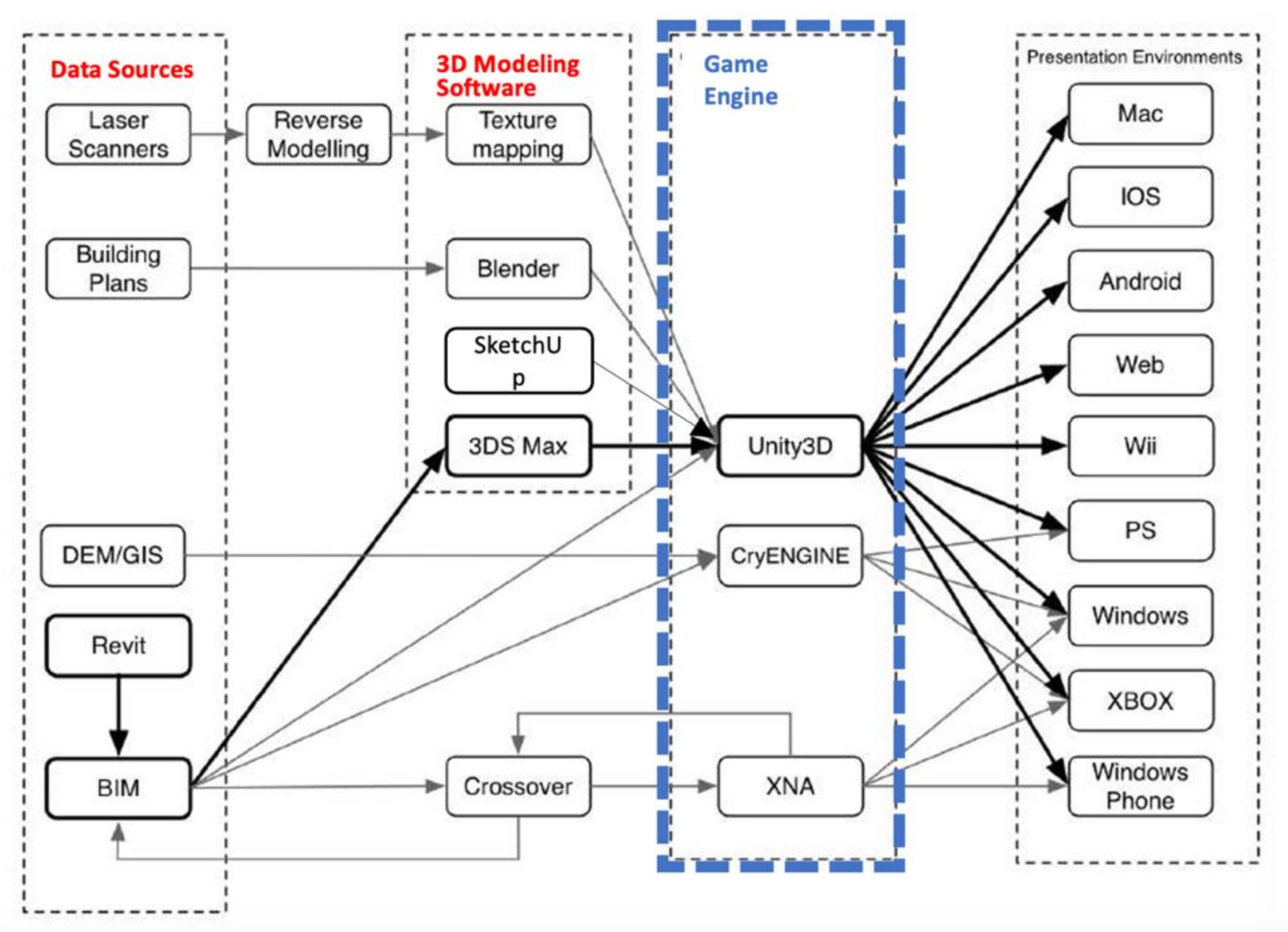
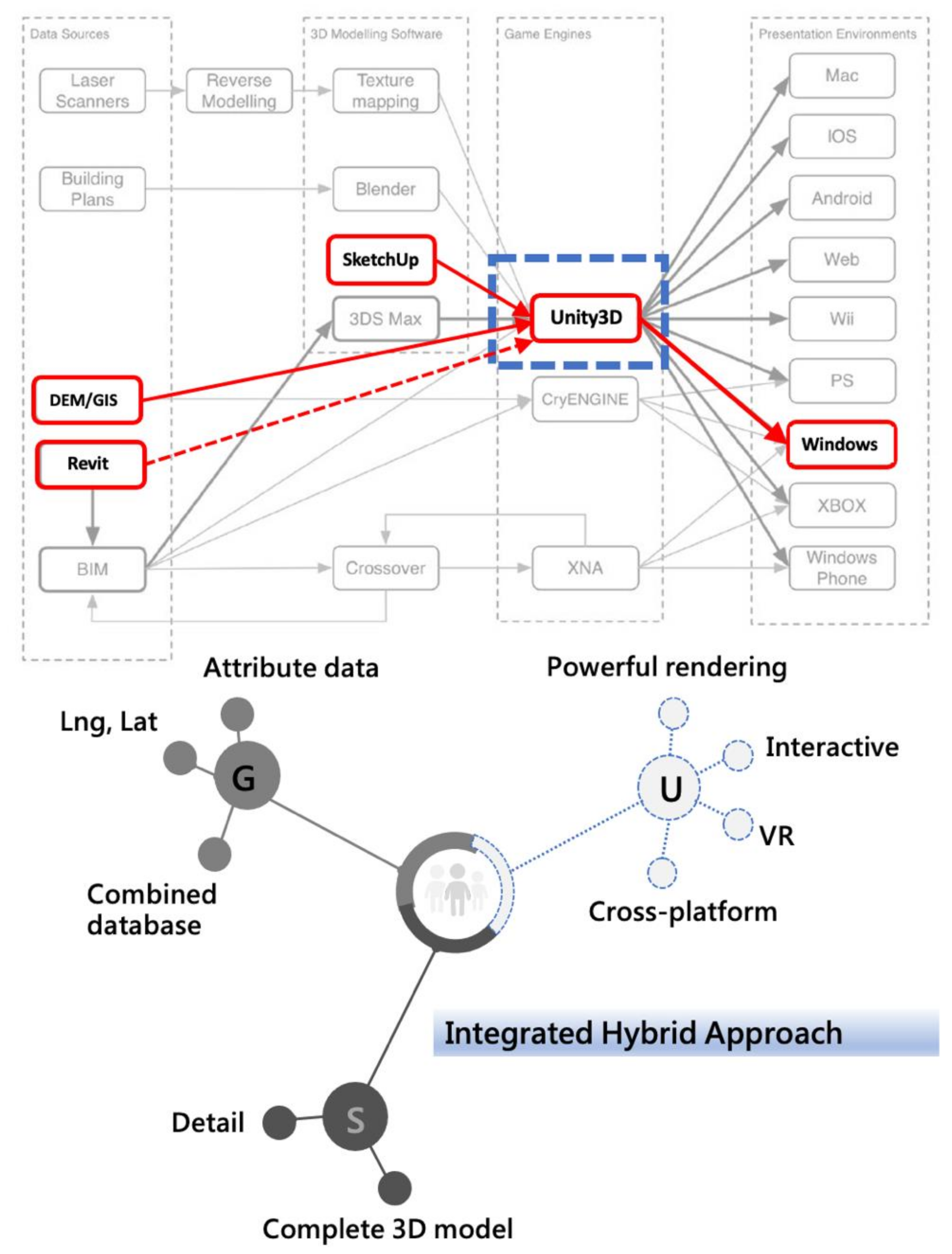
2.2. Integration of Integrated Hybrid 3D Modeling and Information Modeling (BIM) Platform

As mentioned above, there are a number of techniques that can be used independently to create 3D scenes of historical architectural and cultural heritage. High-tech tools, such as the 3D-GIS digital city model, BIM technology, point-cloud scanning, and UAV (unmanned aerial vehicle) aerial photography, have been widely discussed and used in the field of conservation and the reproduction of historical buildings [2,22]. However, as these technologies complement each other, no single technology can fulfill all requirements, thus, integrated hybrid modeling technology should be adopted to overcome the various limitations [23].
GIS and BIM were developed to meet the needs of specific fields, as different areas require different levels of model fineness and quality. BIM supports architecture at a more detailed scale, while GIS supports urban planning at a more macro scale, thus, the integration of BIM and GIS is becoming more common in the AEC industry. The use of parameterized models is very different from GIS in that they have different information sources and differ in scale [24]. Recent studies have also attempted to integrate GIS data with BIM data. BIM focuses on information related to individual buildings, while GIS focuses on topological spatial information and has broader spatial analysis and processing capability [25]. Therefore, the integration of 3D-GIS and BIM 3D city models can assist each other in the performance and control of different scales.
In the case of Henrietta Street [1], the entire historical street was built through point-cloud scanning, and the historical building information model was imported into the BIM platform ArchiCAD to generate the final historical building information model. In the final stage, the model was transformed by CityGML, and using an interoperable format that can share data, it was imported into GIS for further analysis, which is very important for historical modeling.
In the case of the Jeddah district [16], Baik combined the BIM model with GIS data, and regarded it as the next stage of future research, as such integration can optimize BIM and 3D-GIS analysis of historical buildings and cultural heritage sites throughout the district. At present, the principles of 2D-GIS have been applied to 3D-GIS spatial data for more complex analysis, such as disaster management and cultural heritage information preservation. However, as only simple geometric elements are allowed in the GIS platform, it cannot create high-quality 3D models; therefore, the advantages of BIM and GIS should be combined [26]. However, the two models have different details, which will lead to the failure of interoperability in data exchange. Despite these incompatibilities, in order to overcome the specific weaknesses of BIM and GIS, many studies have tried various approaches and ensured that more stable and acceptable integrated hybrid modeling technology can be widely adopted [25].
In the case of Kursunlu Khan in Turkey [14], Saygi et al. mentioned that although databases could be built on GIS, GIS was still limited in terms of its 3D editing function. To solve this problem, they used Autodesk AutoCAD for 2D drawing, and SketchUp and Autodesk 3DS Max for 3D modeling, and then, imported them into the GIS environment, where property sheets were created and connected to relevant building elements. The resulting database allows architects or professionals to search or navigate through the 3D models. While further data integration can be achieved in a GIS environment to provide users with a better understanding of the characteristics of historical buildings and cultural heritage sites, some information may be lost in the format conversion.
In the case of Sant’Apollinare Nuovo, Centofanti et al. also mentioned [26] that, in order to make the database structure more comprehensive and perfect, a perfect 3D model was required. However, as GIS only allows simple geometric modeling on 3D drawing, they suggested using the most common 3D modeling software, such as Autodesk AutoCAD and 3D Studio Max, Robert McNell and Associates Rhinoceros, and INUS Technology, to realize the process of importing 3D models drawn by Autodesk AutoCAD, and Autodesk 3dsMAX into the ESRI GIS environment. The combination of BIM and GIS helps to manage cultural heritage information for cultural heritage conservation planning. The application of information technology (IT) in the field of architectural conservation is a complex workflow, which provides a comprehensive information base and helps us understand cultural heritage information beyond geometric features [14].

2.3. Optimization of the Application of BIM in Cultural Heritage with Game Engine Technology

In the field of the conservation of cultural heritage historical buildings, the 3D digital modeling and information modeling system is an important tool for analysis, reconstruction, and virtual display. In addition to accurate records and real presentation, it can enhance users’ ability to interact with the environment of historic blocks. However, the research of BIM and 3D-GIS mostly focuses on 3D model visualization, which provides users with enough details of urban blocks and building information, but lacks an environment that allows users to interact with the surrounding environment in real time, which is in sharp contrast with the environment provided by Game Engine. As the BIM and 3D-GIS model contains a large amount of geometric and nongeometric information, it is an excellent candidate for importing a game engine to build accurate virtual environments.
The game engine is introduced in real-time architectural visualization, and contributes to the development of high quality interactive architectural environments. The game engine can also add light, weather, sound, and animation to the object for better rendering [11]. VR can provide users with a high-quality interactive experience, which allows users to interact with various objects, such as buildings [13]. The game engine can provide realistic rendering technology, a physics engine, animation effects, application programming interfaces (API), etc., which can assist the designer to experience VR, increase the authenticity and interactivity, and have the ability of tool development. Klein (2016) pointed out that databases in environmental research often fail to be effectively visualized, while game engines can provide powerful tools to construct 3D virtual scenes, as well as first-person and third-person exploration technologies, which allows users to conduct better evaluation and analysis through data links between 3D virtual scenes and the real world [27].
The 3D modeling technology of cultural heritage and historical buildings expands from focusing on a single historical building to an entire street, which leads to increased data size, thus, the application of a game engine in 3D model visualization is receiving more and more attention. In addition to 3D visualization of city models, high-quality virtual environments and their dynamic elements are usually required in architecture and urban design. VR has the potential to enable users to interact, which enhances users’ awareness and understanding of the space, and enables them to make further space exploration and conduct decision-making [28]. In the game engine environment, information can be attached to an object or placed in the right location through a programming language, which improves the visual quality and resilient integration interaction, and allows the use of physical collision and gravity to examine architectural problems. When the model is combined with information, a very flexible system can be realized [29]. If the 3D-GIS data can be integrated with the game engine, in addition to allowing users to obtain a more operational and interactive experience, it can also increase the diversity of preservation and the application of the old city blocks [30,31].
Based on the case results of literature analysis, the development of 3D modeling technology for historical buildings and cultural heritage sites has made great progress, and there are many single software tools available to model historic buildings. Moreover, the field of digital conservation of historical buildings and cultural heritage sites has expanded from focusing on a single historical building to the research trend of old city streets. As the working environment of a single tool cannot meet all the requirements, different modeling techniques must be combined to solve the existing research problems. Therefore, many related studies have begun to combine the BIM model and GIS data as the next stage of future research; for example, building information modeling (BIM) is introduced into the GIS environment to optimize the application of historical building cultural heritage through software integration. However, as GIS and BIM are developed for the needs of specific fields, different fields require different levels of development (LOD) and model quality, which have great differences in communication. Moreover, as there are many incompatibilities between 3D-GIS and BIM software, in the process of integration, the information model will lose some information due to the format exchange. To solve the integration problem, many relevant studies have also started to discuss the use of the game engine as the third-party platform, imported a large number of information models in BIM and 3D-GIS into the game engine, and presented the scenes of historical blocks in a real virtual environment [9,28,29,30,31,32,33,34]. Therefore, the related research trend of integrated hybrid modeling technology also extends from the CAD, BIM, or GIS environment to the game environment, which is presented by the gamified interface and interactive platform (Figure 1).
In game and virtual reality development, the use of game engines to create games has become more and more common. Focusing on the game engines, Unity and Unreal Engine are the two most popular game engines on the market today. They are the go-to tools for most indie developers. Unity has a lot of explanations and articles in Mandarin, and it is easy to get started in the development environment in Taiwan, but in the case of Unreal Engine, it is often used mainly in Europe and the United States, so it is a little hard to find Chinese materials. Additionally, in contrast to being able to use Unity’s features for free, Unreal Engine now allows you to use all features for free, but Unity has released certain features from the paid version. On the other hand, Unreal Engine has adopted a mechanism to collect 5% royalty when making a game that sells.
Although the rendering quality in Unreal scenes is better than Unity, in terms of development efficiency, Unity has a great advantage. Unreal must be authorized to develop through a customized platform and C++ language. On the contrary, Unity can use the free mono platform for development. Unity provides more interfaces for independent developers, and its price strategy is much more flexible. The Unity game engine is a cross-platform system and also provides many open-source technologies. Games can export independent applications for OSX and MS Windows. Game engine assets (Assets) can be imported from different software, such as scripts, materials, models, etc. Objects are also allowed to be simulated in different scenarios [35]. It can help developers easily create comprehensive games such as 3D video games, architectural visualization, and real-time 3D animation. Unity has a highly optimized graphics rendering pipeline for DirectX and OpenGL. It supports all major file formats and can work with most related applications. For example, the FBX format can bring texture and geometry information to the game engine, and it is also the best choice for conversion between platforms. Therefore, Unity was chosen for this study because there are many tutorials, resources, solutions, and skilled users.

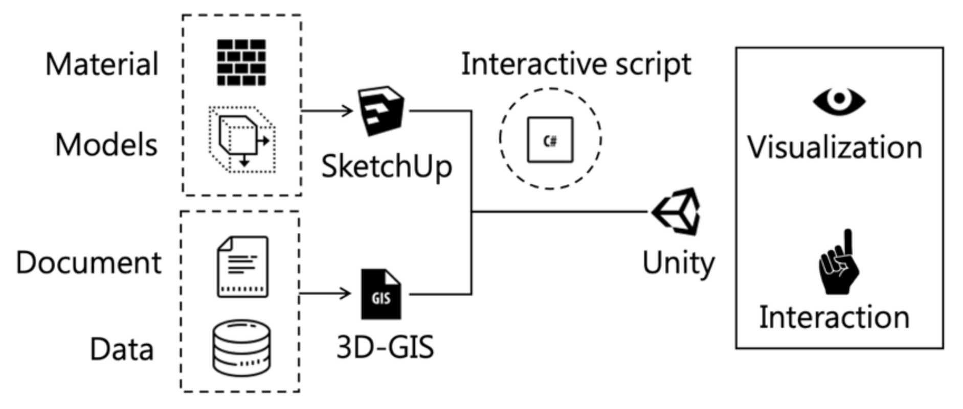
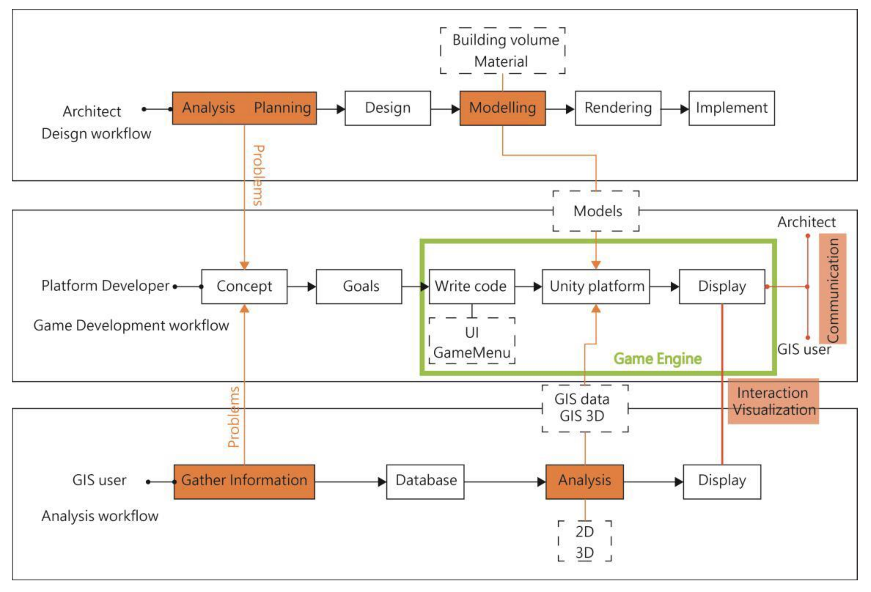
3. Research Method and Procedures

This study is divided into three stages: requirements assessment, software selection, and platform construction and development. First, according to the research background and motivation, the research topic and purpose are introduced, then, the relevant literature is discussed to define the research framework, object, and scope. Based on the needs of this research, the conservation of historical buildings and the application of the hybrid modeling technology and integrated information platform are discussed (Figure 2).
This study integrated a variety of digital platform software tools, chose Game Technology as the development platform, used procedural modeling to build the scene platform of historical blocks, and explored the possibility of Information and Communication Technology (ICT) to promote the re-evolution of the digital process in the field of cultural heritage conservation. Old city blocks and historical buildings in Taiwan were taken as the exhibition objects. Considering that SketchUp is commonly used as a tool to build 3D historical models in the field of cultural heritage, ArcGIS and SketchUp were selected to build the main 2D and 3D information models. Taking Unity3D as the game engine development software, and aiming at information visualization, the interaction of historical buildings, the automatic update technology of the historical building model in the game engine, and the 3D historical building model and 3D-GIS historical block geographic information were integrated through the Unity platform and the third-party game engine, in order to optimize historical building environment information viewing (Figure 3). In order to expand the research on the application ability of cultural heritage display, real-time architectural visualization further creates the interactive game script of the exclusive old city model in the game engine environment through interactive programming.
Based on the literature review, procedural modeling was selected as the research method in this study. Procedural modeling is divided into two stages: information modeling and programming integration (Figure 4). In the procedural modeling stage, the most suitable research tools were selected for this study. GIS digitization and Sketchup modeling were fitted to the game engine to conduct information visualization and the interactivity of 3D historical building models, respectively, and after the prototype was completed, professionals were invited to conduct user evaluation. Finally, the research results were collated, and the user evaluation results were used as reference for conclusions and future research directions.

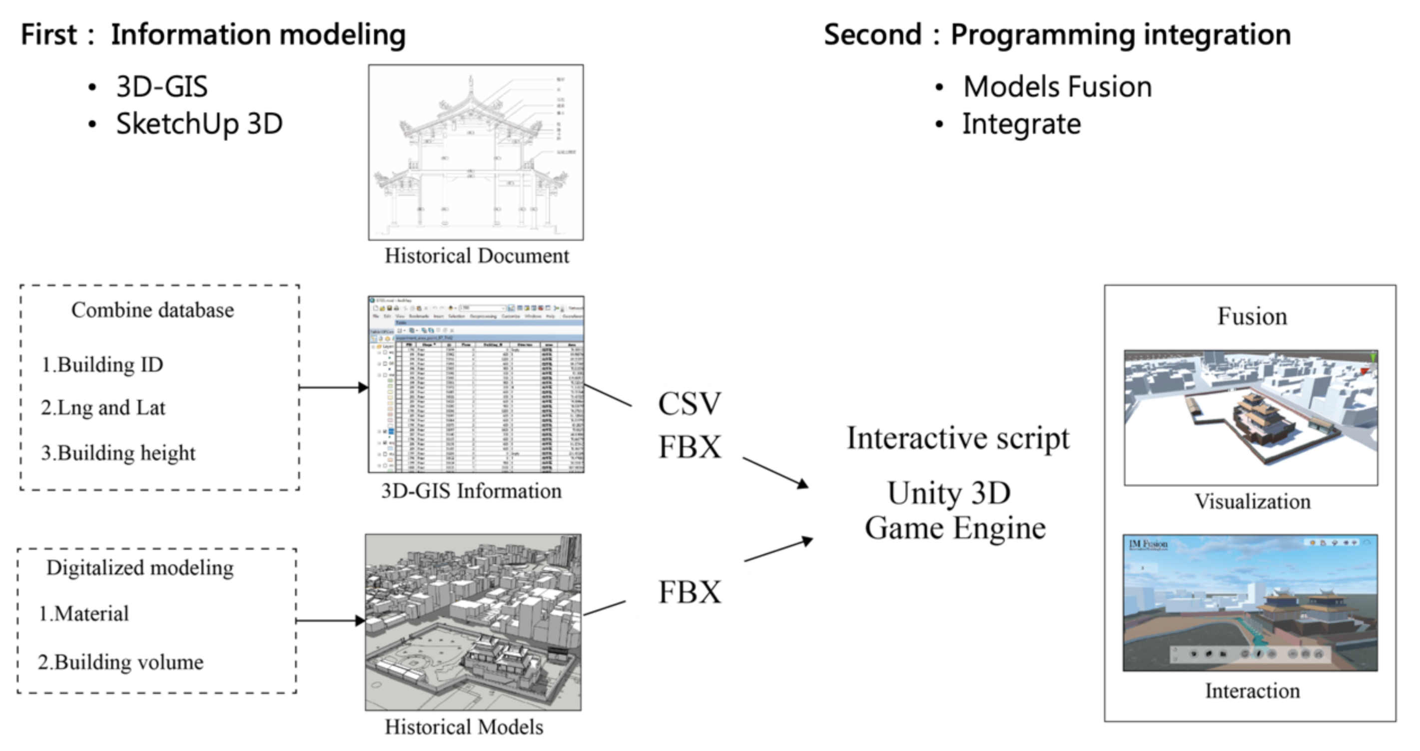
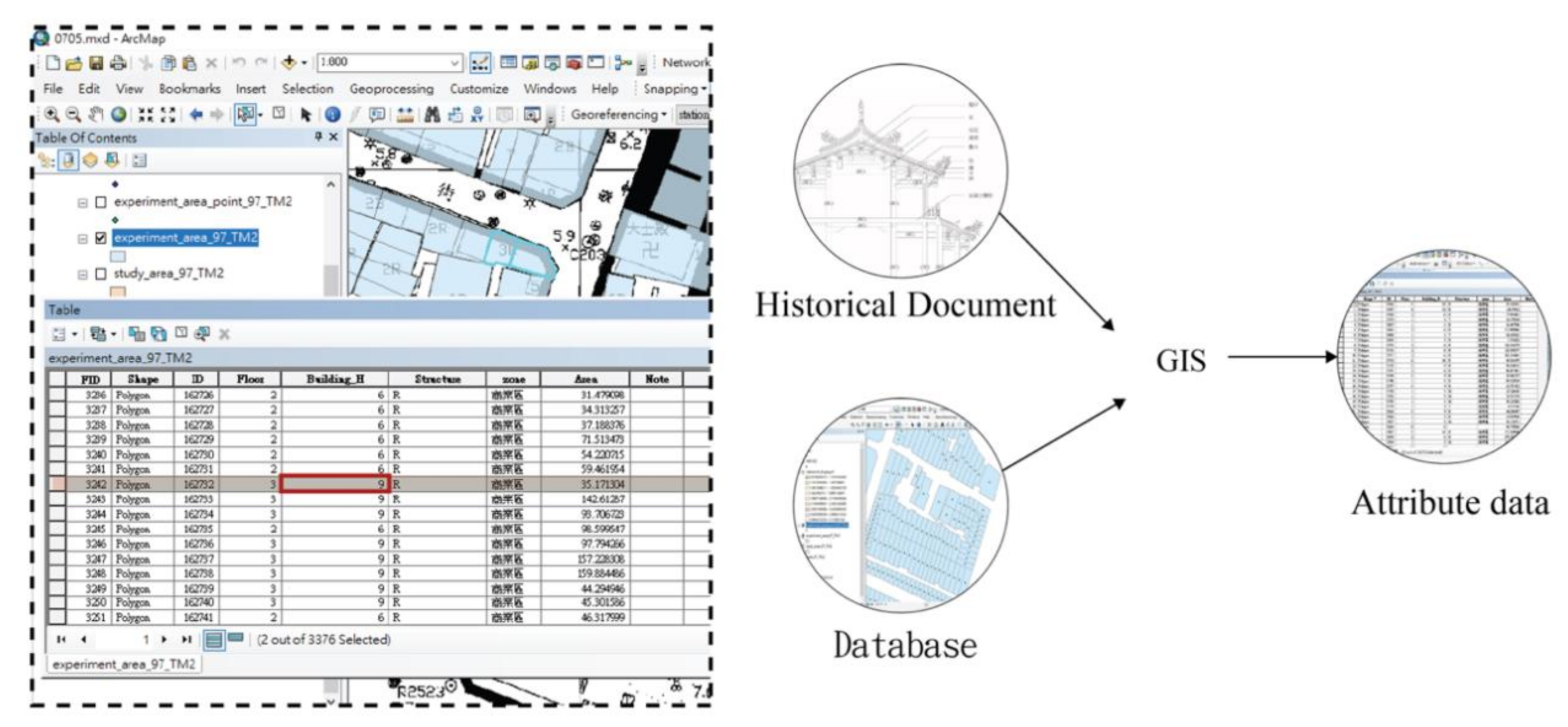
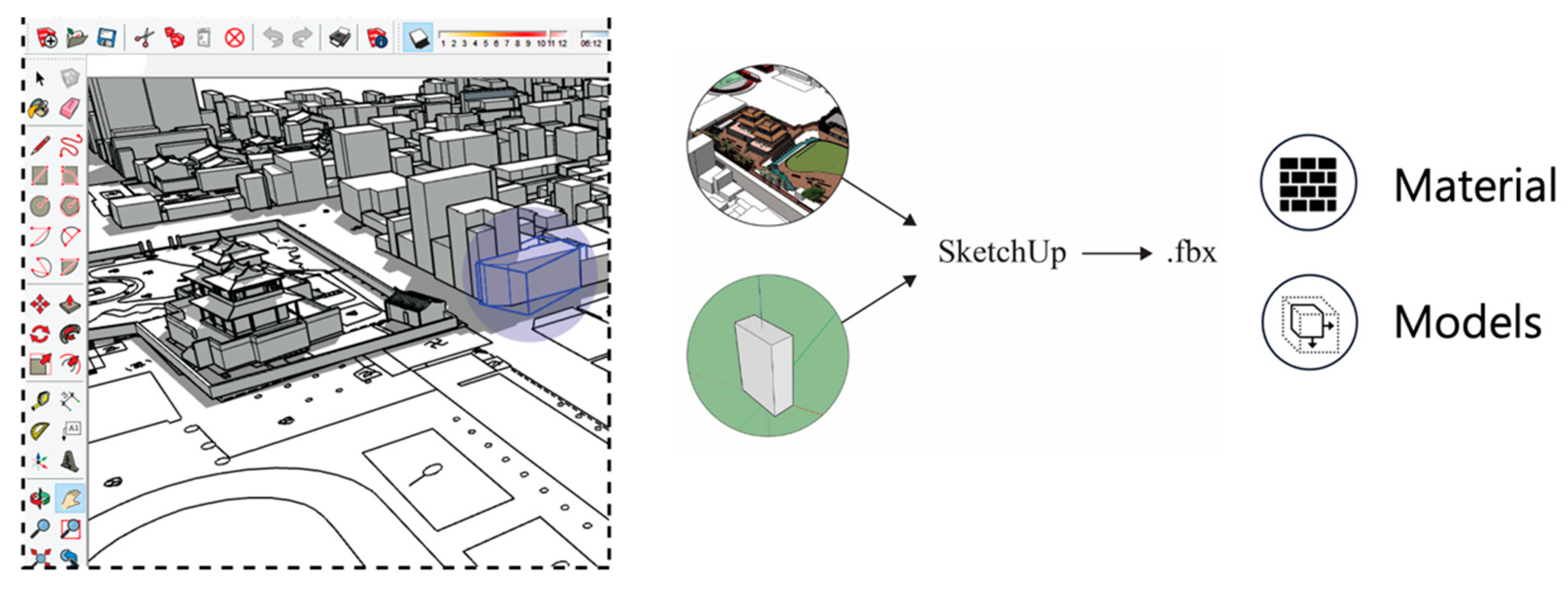
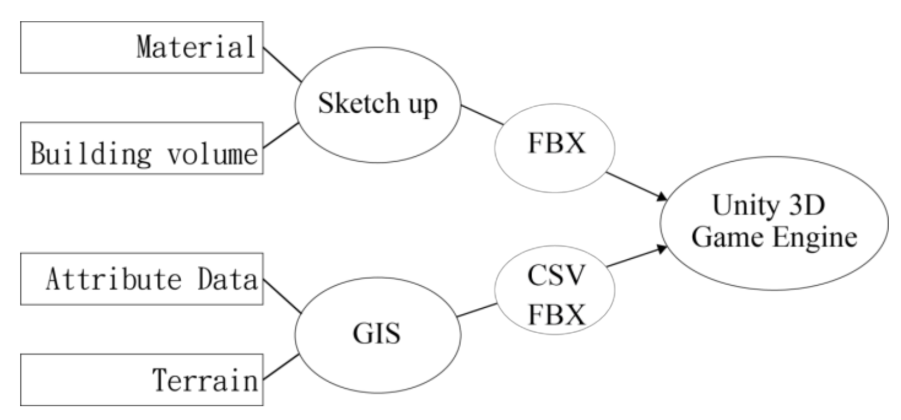
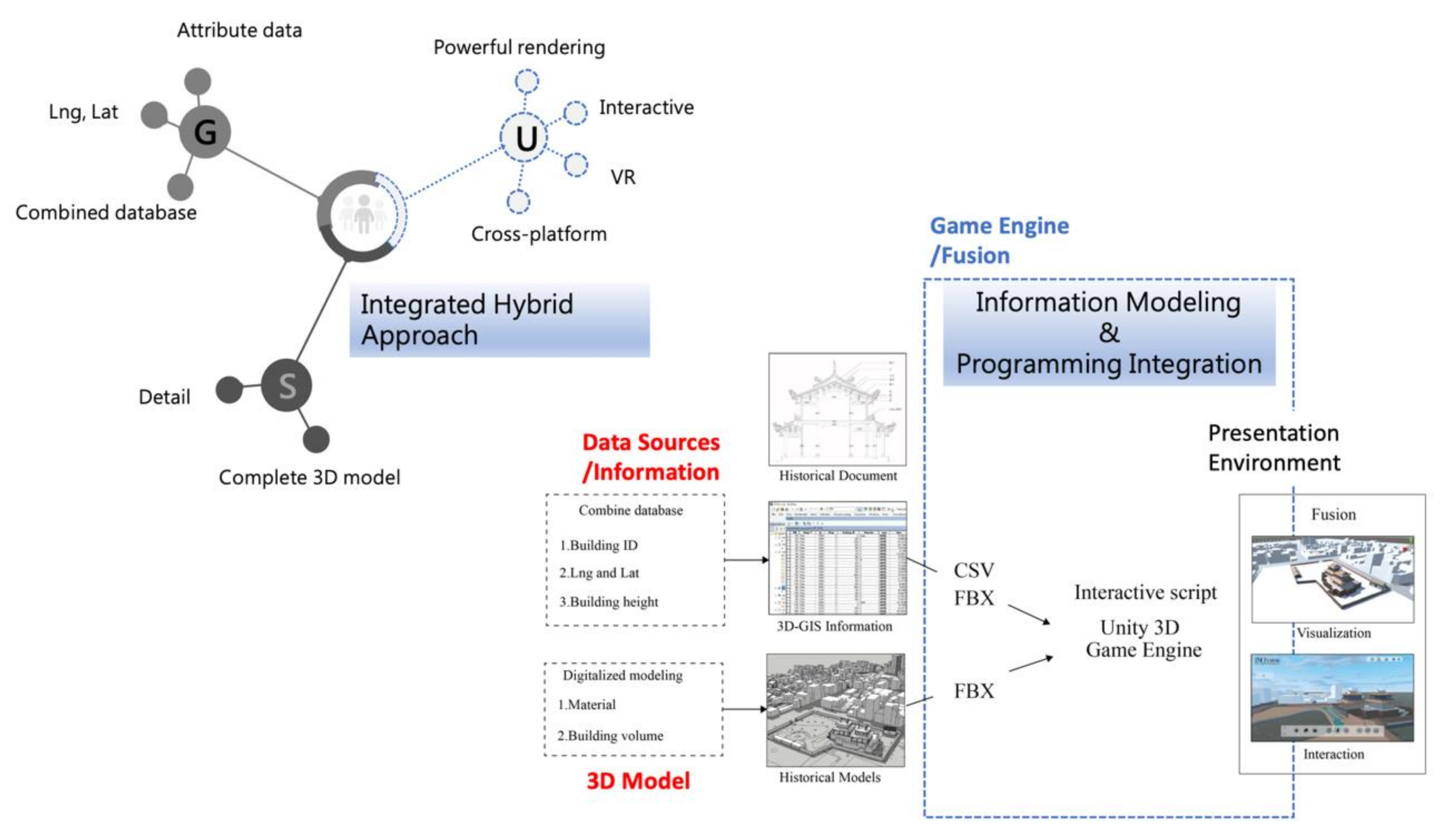
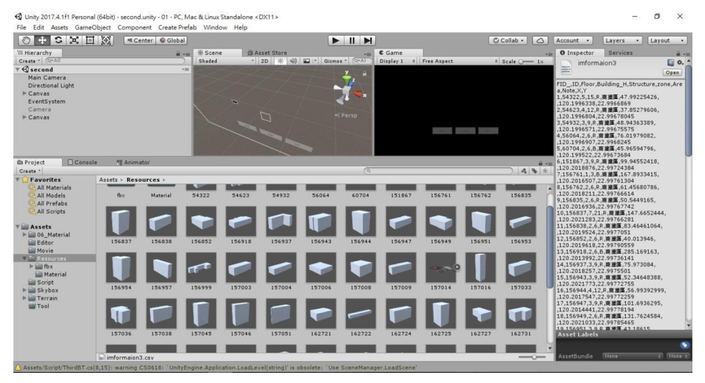
3.1. Information Modeling

The first stage of procedural modeling is information modeling, including 2D modeling and 3D modeling. In 2D modeling, we digitized the GIS database in the way of semiautomatic information, imported the .shp file of the old city block to automatically generate the regional attribute data table, and input the number of floors, building height, building materials, and land use from the historical file into GIS, and obtained the latitude and longitude points (calculate geometry). Finally, the terrain model (Figure 5) of the old city block, as generated from ArcScene, was imported into the game engine as the visualization and interactive object of the terrain structure.
Regarding 3D modeling, this study selected SketchUp, which is a software capable of fast modeling, to build historical buildings, including the materials of the historic buildings and the surrounding building volume, and .fbx was imported into the game engine to complete the 3D old city block model (Figure 6).

3.2. Programming Integration

Programming integration was carried out after the completion of information modeling, including information model fusion and interactive design.

3.2.1. Information Model Fusion

Considering the future application scope, modeling software should not be limited in the process of information fusion between the 3D geometric model and the nongeometric abstract data. Any software that can be used to model historic buildings and cultural heritage sites can be used as a tool for geometric modeling. This study used SketchUp for the construction demonstration. In addition, the GIS attribute table was used to provide architectural information, the geometric model and nongeometric data of the historical block were imported into the Unity scene through the fbx format and csv file, respectively, and the entity model was linked to the attribute data table through the object-oriented programming of the Unity3D game engine.
The FBX (Filmbox) format is a popular 3D data interchange format utilized between 3D editors and game engines and enables all those applications to share 3D data. As SketchUp Pro can export an FBX file (.fbx), we created scenes in SketchUp and then exported that data to FBX for use with other applications that support FBX. CSV (comma separated values) is a common data exchange format that typically stores tabular data (numbers and text) in plain text, in which case each line will have the same number of fields. We exported the feature attributes or a table to a CSV file (.csv), in ArcGIS. Unity supports FBX files which export from many 3D modeling applications. The attribute tables of corresponding buildings were extracted from the 3D-GIS model to conduct automatic information matching with the entity model, multiple applications of the GIS database were effectively activated to avoid information loss of transfer files between platforms, and spatial exploration was optimized in the Unity3D virtual environment (Figure 7).
Through the collaboration of the game engine and the database, the whole building life cycle can be adjusted in the VR environment, and the different LODs can be achieved through scene transformation. In the future, it is expected that the entity model and the attribute data can both be updated.

3.2.2. Interactive Design

While SketchUp can create highly detailed information models and 3D-GIS is capable of powerful data analysis, they lack “realistic” and “highly experiential” interactive virtual collaborative design environments. The highly visual information model and interactive design environment can improve user feedback and communication between users and objects. Therefore, after the completion of information model fusion, interactive program scripts were written to connect real-world data and virtual space models, and enhance the “realistic” and “highly experiential” interactive virtual collaborative design environment. The communication between experts and information models in different fields has been completely improved (Figure 8).

4. Platform Design and Development

Unity 3D was used as the platform to develop the software, and the database and 3D model were integrated through the programming language. The abstract database could be obtained from 3D-GIS, while historical building models and terrain models could be obtained from Sketchup and 3D-GIS. Information visualization and the interactivity of historical buildings and old city blocks could be displayed through Unity. Therefore, the tools for program modeling technology in this study are SketchUp and 3D-GIS, and the program modeling technology is integrated through Unity3D.

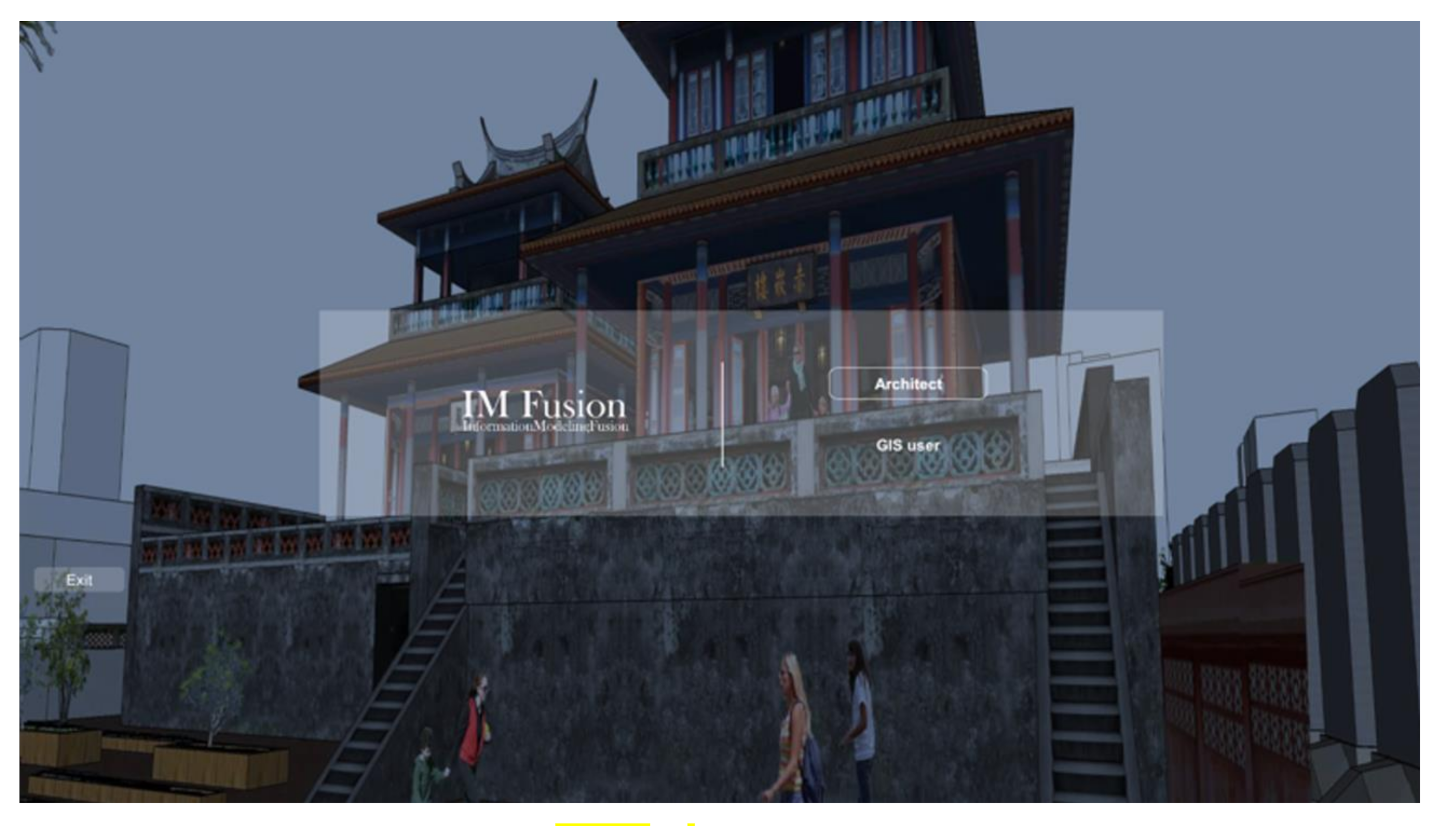
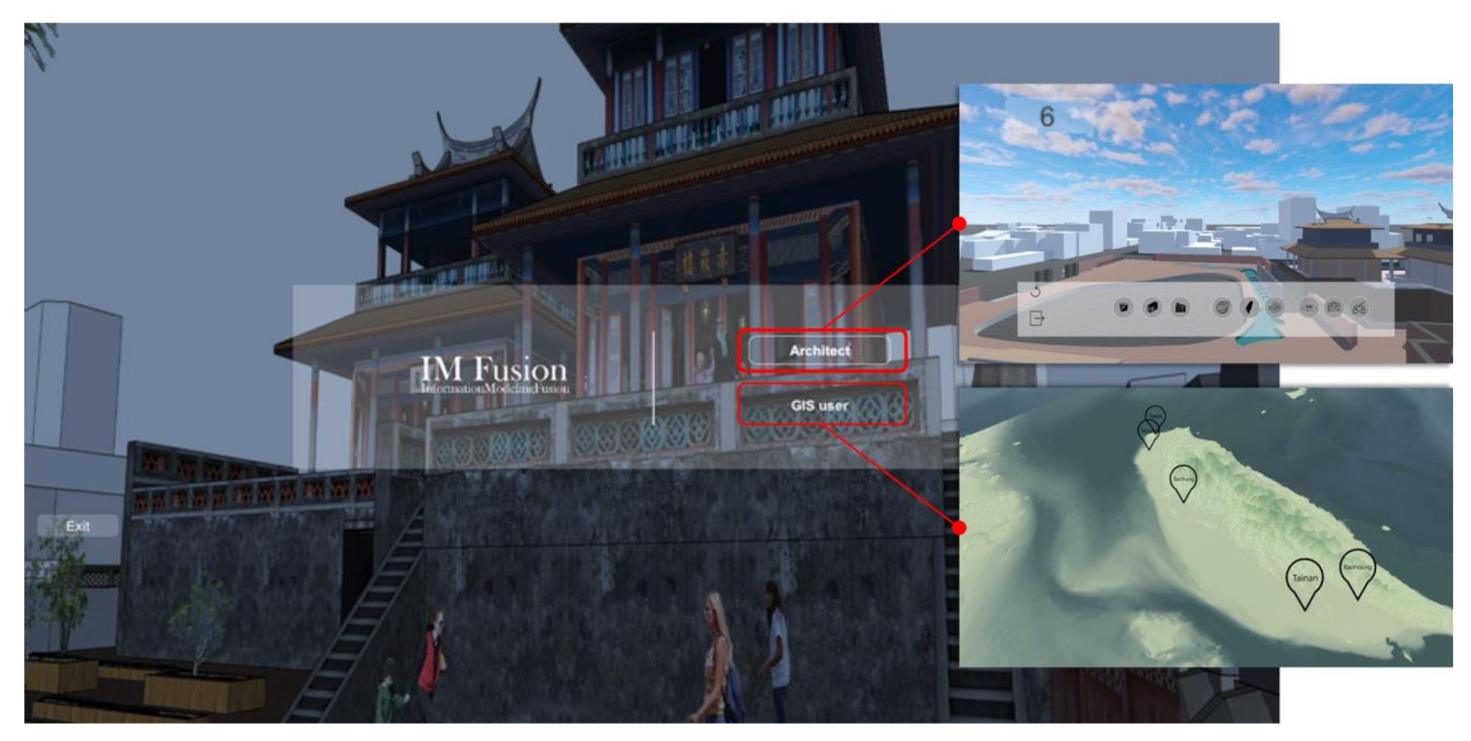
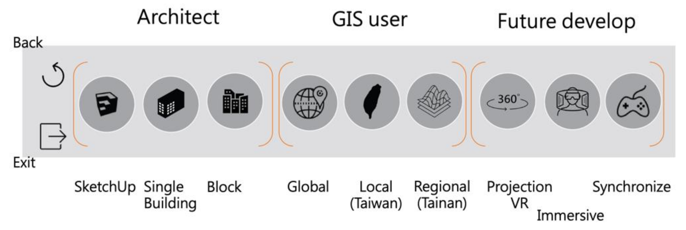
4.1. Contextual Design for Platform Users

There are three purposes for the development of this platform: (1) integrating the historical building model with 3D-GIS attribute data; (2) professionals can automatically visualize all the required information in the Unity scene; (3) real-time updating of historical building models and data; therefore, the platform users are professionals, architects, and GIS users. Figure 9 shows the architect’s design workflow and GIS user’s analysis workflow. This study only discusses the workflow involved in the field of cultural heritage conservation. Architects and GIS users can present problems to the platform developers during analysis planning and data collection, which can be used as the concept for platform development. After the goal is set, the programming language is written in the Unity game engine, including the user interface design and menu design. Then, architects can import the historical building model and material into Unity, and GIS users can import the 2D analysis data and 3D terrain model into Unity. Finally, the historical building and the old city block model are displayed.
The key value of this platform is that it can integrate information from different fields, and help architects communicate more effectively with professionals in different fields, such as GIS users, or improve communication between the platform and architects or the platform and GIS users. In short, the communication between people, or between people and things, can be improved, which is consistent with the theme of this study stage: using game technology to improve the interaction and visibility of 3D-GIS.

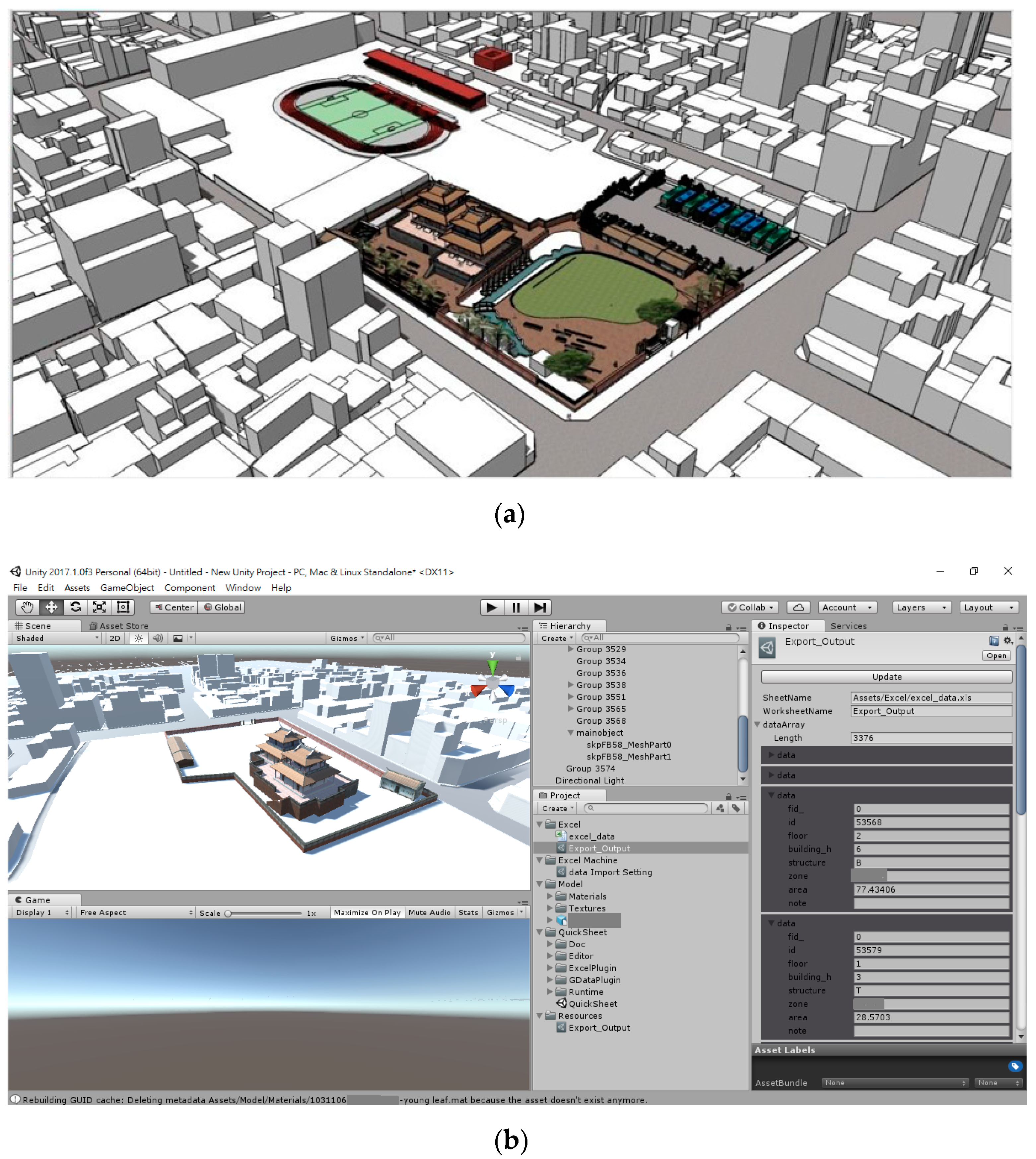
4.2. Information Models and Digital Content

Historical documents, historic building models, and 3D-GIS information were studied in the first phase of this project. A valuable historical building model includes the following information: architectural coordinates, historical documents, materials used, structural systems, and architectural elements [20]. Therefore, the digitization process of the historical building model in this study includes the material and volume model. In addition, the semiautomatic information approach was used to digitize the GIS database, while the shape file (.shp) data, as obtained from the open data, was combined with the existing geographic information, and the longitude and latitude coordinates of the building were found in GIS. Through the programming of the interactive program script, the historical building model and 3D-GIS attribute data were integrated with the game engine, so that each building volume model could be linked to its corresponding 3D-GIS attribute table. The function of the game engine is mainly to improve the visibility and interactivity of the 3D-GIS information model of old city blocks (Figure 10).

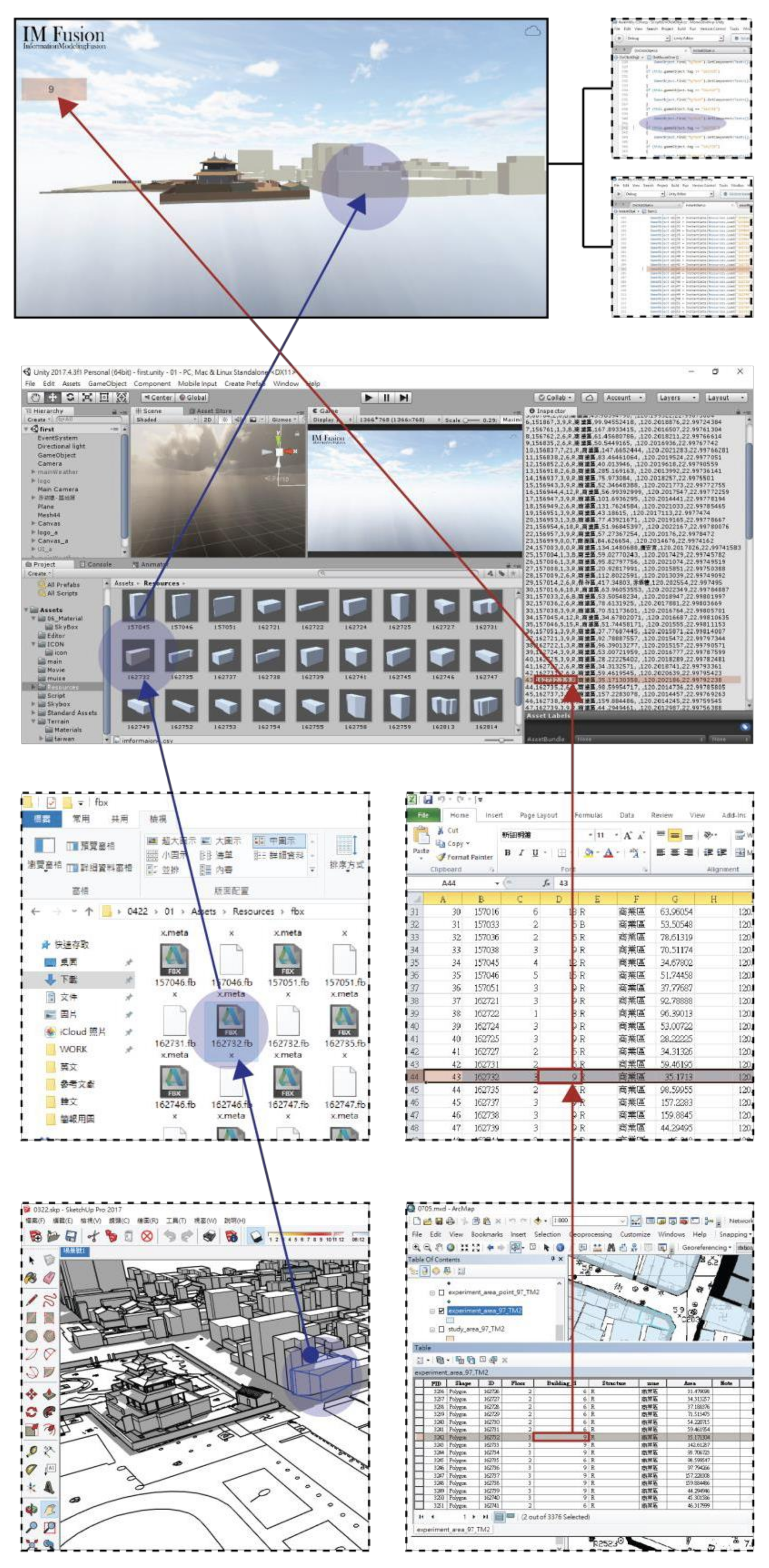
4.3. Interactive Programming

Unity integrated .csv from GIS and the volume model built in SketchUp. In Sketchup, the model was exported as .fbx and imported into Unity, while the attribute data of GIS was exported as .csv for Unity to read and confirm the data and the volume of some buildings (Figure 11).
Two C# interactive scripts were written in Unity to integrate historic buildings and old city blocks with the information models. First, the longitude and latitude coordinates of buildings generated by GIS were linked. In GIS, this study calculated the center point of Polygon, and took the center point of the building as the longitude and latitude coordinate points. Through the C# interactive program script in Unity, the model was linked with the longitude and latitude information, and the volume model was placed in the correct coordinates. Secondly, the attribute data of the building can be visualized by using the C# interactive program script in Unity in the GIS-generated ID Tag volume model. Therefore, the position of the volume model is coordinated according to latitude and longitude, and the displayed information shows the height of the building (unit is meters) (Figure 12).

4.4. Interface Design and Application

4.4.1. Interface Design

Based on the workflow of architects and GIS users, this study provides an interface that is intuitive, operational, and convenient. As this platform has a unique UI design, it meets the needs of professionals to improve the communication between the platform and users. This platform is called IM Fusion (information modeling fusion), which is an interactive platform used to build a virtual world and amplify the VR display based on real world data. As a city has many different elements, integrating historical building models with geographic information requires that the real world is considered, thus, digital city models are complex systems. Therefore, this study took architects and GIS users as the user objects, and only selected the model information required by these two different fields for application in cultural heritage conservation as the display objects of IM Fusion.
There are two kinds of applications on this platform (Figure 13). Architectural professionals engaged in cultural heritage conservation have focused on historical buildings and surrounding buildings; however, such structural information is not easily obtained by architects. On the contrary, for professionals in the field of geographic information, as building models lack details, not all buildings can be accurately and individually edited. Therefore, through IM Fusion, this study connects the workflow of architects and GIS users to enhance data sharing and collaboration in different fields.
The user interface of the platform has setting options for architects and GIS users, respectively (Figure 14), and scenes can be selected according to the users’ professional field or the content they seek.
Therefore, the historical building model will appear after the user selects the architect option in the menu screen, which is designed according to the habitual workflow of architects, while Taiwan’s terrain will appear when the GIS User option is selected. The field of GIS was started from the analysis of large scale data (Figure 15).
In order to improve the communication between architects and GIS users, this study designed different options for different users in IM fusion (Figure 16); the three on the left are the common instructions used by architects, which are model scene, single building information scene, and old city block scene in order. The three geographic information scenarios in the middle are the common instructions used by GIS users, which are global terrain, region or country, and administrative region. The three on the right are the future development functions for the platform. The integrated VR interactive interface can be used for virtual presentation, immersive devices, or multiplayers. In the overall process of scene transformation, users can enter the platform with any identity and select each scene.

4.4.2. Application of IM Fusion

The size of IM Fusion is set as 2664*768, which is the ratio of iSpace-Urban Simulation and the Cloud Computing Laboratory of Feng Chia University. The iSpace-Urban Simulation and Cloud Computing Laboratory of Feng Chia University is the only visual simulation laboratory in central Taiwan (Figure 17). By integrating the developments of game environments and 3D interactive technology in this study, users can have a better understanding of the environmental information of old city blocks for design evaluation, in order to achieve information visualization and interaction, and expand the multiple applications of iSpace (Figure 18).
This study focused on the development of an interactive city script and UI design for the reconstruction of an old city block. The SketchUp model is connected with the corresponding objects in the GIS model through writing the interactive programs in Unity. In addition to solving the issue of data loss, as caused by transferring files of different formats for integration, the model information can also be updated at any time by means of file transferring. The issue of large execution files can be improved, and visual complexity can be reduced by setting how the model visualizes the scene, in order to expand the display ability of cultural heritage sites.

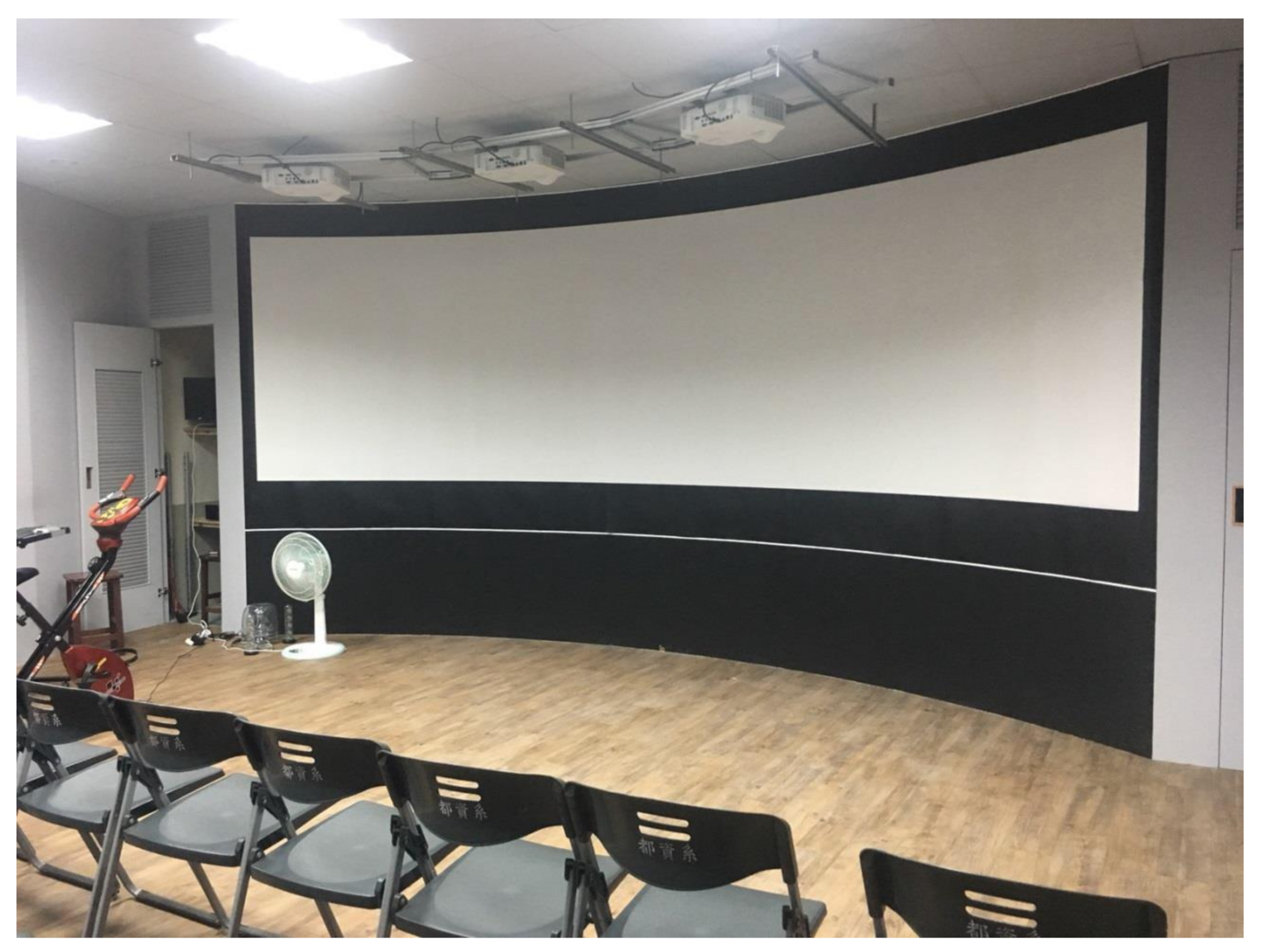
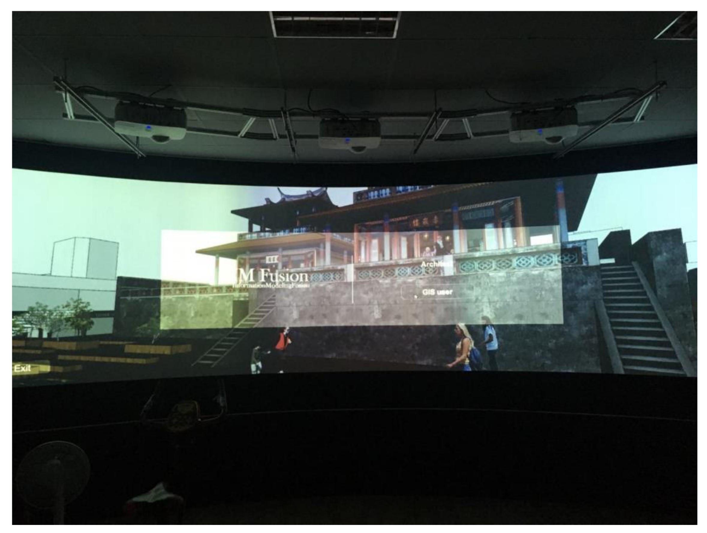
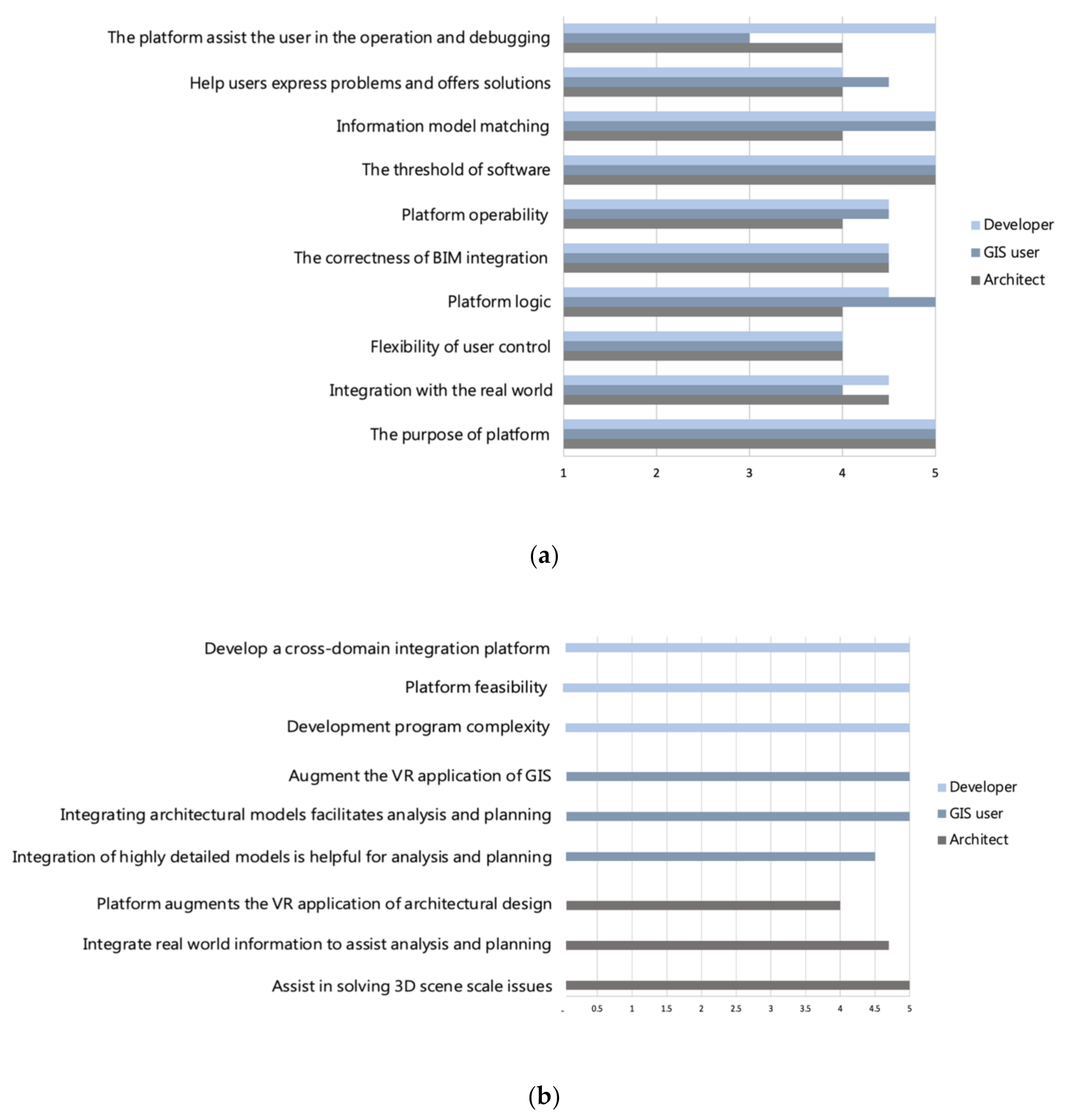
4.4.3. Platform Usage Evaluation

This study developed a platform to integrate historical buildings and 3D-GIS data to improve the interactivity and visibility of digital historical buildings. In order to improve the platform, user interviews were conducted to understand whether the development of the platform would be helpful for architects, GIS users, and platform developers in the field of cultural heritage conservation.
In response to the research questions raised in this study: it is not easy to integrate a single historical building with an old city block model, and the existing information model of the old city is insufficient in interactivity and visibility. The respondents in this study are architects, GIS users, and developers, with three respondents from each background, respectively. Three architects with experience in the field of cultural heritage conservation were selected, and this study did not subdivide GIS user respondents. The selected developer respondents had experience in platform development and game development, or interactive program writing using programming languages JavaScript, Python, or C#. All the respondents have computer application experience.
The Unity3D game engine is a cross-platform system, which avoids the incompatibility problem of different users using different computer systems. Since the time and location of the respondents were different, this study set two interviewing methods: online visual communication and operation and interviews conducted in the iSpace-Urban Simulation and Cloud Computing Laboratory of Feng Chia University. After confirming the environment selected by the respondents, we provided a brief description of the platform, so that users could understand our purpose and the overall structure of the platform, and then, asked each user to operate the platform results in the form of execution files. In order to more clearly understand what is necessary for experts in different fields, and what they expect to present, users raised questions and gave comments after the operation.
The content of the questionnaire is divided into three parts: (1) basic data, including personal background and the computer application experience of respondents; (2) according to Jakob Nielsen’s (1995) usability heuristics for user interface design, this study presented 10 common questions to all the respondents, and asked them to make objective choices in a five-equidistance manner; (3) three questions were presented regarding the opinions of the respondents from different backgrounds after using the platform.
At present, we have completed the link to the SketchUp solid model and 3D-GIS attribute data table through script writing, and designed the basic instructions commonly used by architects and GIS users, so that users in these two fields can use the models and data. The users indicated that they are highly impressed by the platform’s purpose, the integration of historical building information models, and the ability for professionals to automatically visualize all the information they require in a Unity scene. This study also successfully integrated the GIS database and 3D SketchUp model of old city blocks, and used Unity to complete the visualization of the information model, thus, reducing the time cost for browsing drawings. Moreover, the simulated and highly spatial experience can also improve the spatial perception of users. This platform design conforms to the workflow of professionals in the field of cultural heritage conservation.
In terms of interactivity, game development is mainly based on Unity. This study invited professionals to control the keyboard and mouse to guide the movement direction of the perspective; therefore, this is also an intuitive way for professionals to gain computer application experience. This study can change the environment, switch scenes, solve the LOD problems needed in different fields by writing programming language, and use interactive program scripts to allow users to walk around the old city in the first-person perspective, thus, this Unity development platform indeed reduces the software barriers. In the past, professional software had to be trained to work independently, while this interdisciplinary information and information model provides a simple operation mode through IM Fusion.
According to user context analysis, as this platform is designed for users from different fields and backgrounds, users can intuitively operate the UI, and use this platform as an object for environmental guidance and space experience in historical buildings. According to the results of the questionnaire (Figure 19), this platform is indeed helpful to solve the problem of the 3D scene scale in the field of architecture, and the integration of real-world information is also helpful for planning and analysis. Moreover, the shortcomings of GIS visualization are also improved. For developers, this platform has low complexity, high feasibility, and great potential for developing cross-domain integration platforms. Therefore, the development objectives and integration projects of IM Fusion can help architects and GIS users to conduct analysis and planning, and improve the interactivity and visibility of 3D-GIS, thus, the development feasibility of the platform is quite high.

5. Results and Future Studies

5.1. Conclusions

In this study, we successfully integrated the GIS database and the 3D old city block model, and completed the use of the Unity game platform as follows: (1) integrate historical building models and 3D-GIS attribute data; (2) get all the necessary visual information; (3) update historical buildings and historic district models and data at any time; (4) provide virtual reality simulation function and environmental interaction experience. Both professional and nonprofessional users can intuitively operate this platform to conduct research on restoration or as an environmental navigation and historical space experience.
This research focused on interactive game script development and user interface design for the historic district regeneration. The attribute data in CSV format form 3D-GIS software and the its data entity model created by SketchUp with different detail descriptions in FBX format are recombined in the Unity environment. In addition to avoiding the problem of integrating missing data in different formats and translating data, it is also possible to update the model with different details at any time. At the same time, through the visual settings of the scene in Unity environment, the big file loading problem of urban model can also be improved.
We believe that in the possible development direction of the historic district regeneration, using game engines to optimize integration processes of information models will effectively enhance their visualization and interaction. This platform system chooses to conduct development experiments in a semi-immersive VR environment (iSpace). Currently, user interface testing is ongoing, and system stability and interface design are continuously revised.

5.2. Discussion

At present, this study has completed the linking of 3D-GIS macrocosmic information with Unity, integrated historical building models and 3D-GIS attribute data, and can automatically match buildings with the same ID information through the writing of interactive program scripts, in order to facilitate reading and simulating the macro building environment information. Professionals can automatically visualize all the information they need in a Unity scene. This study designed user situations for professionals, meaning interdisciplinary information and the information model can be presented through scene switching, which is in line with the workflow of professionals. Moreover, the platform can update historical building models and data in real time; provided the model and edited text file (CSV) are extracted from the local database system, the information can be automatically updated.
In addition, as IM Fusion offers the function of VR simulation and an interactive experience with the environment, both professional and nonprofessional users can intuitively operate the platform to conduct restoration surveys, or take it as an object for environmental guidance and spatial experiences in historic buildings. In the research process, this study found many integration problems, which are mainly related to the integration of the database and the model in Unity, which limits the visualization and interactivity of this research. The following outlines the problems and possible solutions:
  • When an Overlay is tapped to display information in Unity, the Mesh must be touched; however, there is a parent–child relationship in Unity, which makes the Mesh at the bottom of the object. While this study separated the Mesh from the object, the number of 3D old city block models is very large, thus, when there are many complex objects in the scene, and they contain various materials, it takes a lot of time to organize the information model, which cannot reduce the time cost.
  • The research scope of this study is the old city streets around Chi Kan Tower, and the number of buildings is over 3000. As manually importing each information model has the potential for errors, after integration, there is no way for Unity to automatically detect errors.
  • When integrating the model and data, it was found that the cadastral map of the building model and the cadastral map of the geographic information could not be completely consistent due to the different measurement methods, which reduced the accuracy of the longitude and latitude coordinates.
With the rapid development of technology, we look forward to overcoming the above-mentioned problems and directing this platform to an automated process. All model information and environmental information can be automatically updated due to the sharing of data, so that it can be easily provided to different fields of professionals to conduct analysis and planning.
Therefore, this research proposes three solutions for the next stage: first, through the programming of a programming language, the object can be automatically sorted and the material of the object itself can be obtained. Second, add triggers to each object so that the back-end administrator can discover problems in time during testing. Third, in response to the problem that different professional fields cannot correspond to the drawing files and data, when a high-detailed single building body is required, we mainly use the data provided by the construction field. In contrast, when a large-scale environmental structure model and urban information model are needed, the quantitative information provided by the geographic information field is the mainstay.

5.3. Future Studies

The platform of this study can integrate different fields of expertise, and when such different fields can be linked to more databases, the platform will have more application capabilities. At present, this platform can link 3D-GIS macro information and Unity to simulate and display the macro building environment. As the current version can only read and display, the integration of Unity and the GIS coordinate system means every building must have its longitude and latitude coordinates to complete the information model, which shows that links between coordinates and databases will strengthen the overall platform for the future developments of environmental assessment simulation. In addition, the short-term goal of the next stage is to realize a linking application for the BIM model and Unity. At present, the BIM Revit model information is extracted through Revit Dynamo (parameter tool), while Unity is used for the visualization and interactive application of historical building components. The goal of this study was to integrate BIM and 3DGIS into the Unity environment, so that different platforms can work together and avoid format problems caused by data exchange between different platforms, and thus, carry out two-way link updates during game execution. All changes are expected to be automatically transmitted and updated between the different environments.
The development of this platform has the key technologies for the integration of different professional fields. Combined with the GIS coordinate system, each building has its latitude and longitude coordinates, which will be helpful for future development. For the disadvantage of model data that can only be imported into the Unity environment in one direction, it is also expected that it can be broken through the platform. Both the entity model and attribute data can be a bidirectional update in Unity and ArcGIS will be our future efforts. The Unity platform that can be developed in the future include the following three points:
  • In the future, our platform can link with more different databases to build a more complete integrated system platform.
  • A Web-based platform can be developed to navigate the city model.
  • It is allowed to add LBS (location-based services) and use latitude and longitude to connect with real world for more applications.
In this research, we successfully used the game technology to improve the visibility and interactivity of spatial data, and performed platform implementation and usage evaluation. The assessment has the task of linking spatial data and 3D visualization. We invited many participants from different fields in architecture, urban planning and program development to conduct user evaluations. These participants have different spatial and memory abilities. From the user’s perspective, 3D environments created with VR compatibility can be experienced from an egocentric and stereoscopic perspective that surpasses the immersion of the ‘classical’ screen-based perception of 3D environments. The results of this research provide unique empirical evidence and contributions. According to the statistical results of the questionnaire, this platform does help solve the problem of 3D scene scale in the architectural field, and the integration of real-world information is also helpful for analysis and planning [10].
Not only game developers benefit from the possibilities provided by game engines. The ability to use geospatial data to shape virtual 3D environments opens a multitude of possibilities for geographic applications, such as construction planning, spatial hazard simulations or representation of historical places [10]. The integration of more detailed models is helpful for analysis and planning in the field of GIS, and the lack of visualization can also be improved. For developers, the development process of this platform has low complexity and high feasibility, and it has great potential in developing cross-domain integration platforms. This article explains how game technology integrates geometric models and nongeometric information from different tools and platforms, and provides visual environment information, which will help to improve the future research of immersive virtual 3D environment visualization [36].

Funding

This research was funded by the Ministry of Science and Technology of Taiwan, grant number MOST 106-2119-M-390-002.

Acknowledgments

This research was supported by the Ministry of Science and Technology of Taiwan for the generous research grant, the coded number: MOST 106-2119-M-390-002. I greatly appreciate my master student, Hsin-Hui Lien, for her technical assistance in the development of the system. I also would like to express my deepest appreciation to all those who provided me the possibility to complete this report.

Conflicts of Interest

The authors declare no conflict of interest.

References

  1. Dore, C.; Murphy, M. Integration of Historic Building Information Modeling (HBIM) and 3D GIS for recording and managing cultural heritage sites. In Proceedings of the 2012 18th International Conference on Virtual Systems and Multimedia (VSMM), Milan, Italy, 2–5 September 2012; pp. 369–376. [Google Scholar]
  2. Moghadam, S.T.; Lombardi, P.; Mutani, G.; Osello, A.; Ugliotti, F.M. BIM-GIS modelling for sustainable urban development. In Proceedings of the Towards Post-Carbon Cities, SBE16, Turin, Italy, 18–19 February 2016; pp. 18–19. [Google Scholar]
  3. Li, X.; Lv, Z.; Hu, J.; Zhang, B.; Shi, L.; Feng, S. XEarth: A 3D GIS Platform for managing massive city information. In Proceedings of the Computational Intelligence and Virtual Environments for Measurement Systems and Applications (CIVEMSA), 2015 IEEE International Conference, Shenzhen, China, 2–14 June 2015. [Google Scholar]
  4. Hor, A.H.; Jadidi, A.; Sohn, G. BIM-GIS integrated geospatial information model using semantic web and RDF graphs. ISPRS Ann. Photogram. Remote Sens. Spat. Inf. Sci. 2016, 3, 73–79. [Google Scholar] [CrossRef] [Green Version]
  5. Park, T.; Kang, T.; Lee, Y.; Seo, K. Project cost estimation of national road in preliminary feasibility stage using BIM/GIS platform. In Proceedings of the Computing in Civil and Building Engineering, Orlando, FL, USA, 23–25 June 2014; pp. 423–430. [Google Scholar]
  6. Holness, G.V.R. Building Information Modelling. ASHRAE J. 2006, 48, 38–46. [Google Scholar]
  7. Jamei, E.; Mortimer, M.; Seyedmahmoudian, M.; Horan, B.; Stojcevski, A. Investigating the Role of VirtualReality in Planning for Sustainable Smart Cities. Sustainability 2017, 9, 2006. [Google Scholar] [CrossRef] [Green Version]
  8. Parise, S.; Crosina, E. How a mobile social media game can enhance the educational experience. J. Online Learn. Teach. 2012, 8, 209. [Google Scholar]
  9. Yan, W.; Culp, C.; Graf, R. Integrating BIM and gaming for real-time interactive architectural visualization. Autom. Constr. 2011, 20, 446–458. [Google Scholar] [CrossRef]
  10. Keil, J.; Edler, D.; Schmitt, T.; Dickmann, F. Creating Immersive Virtual Environments Based on Open Geospatial Data and Game Engines. KN-J. Cartogr. Geogr. Inf. 2021, 1–13. [Google Scholar]
  11. Koehler, T.; Dieckmann, A.; Russell, P. An Evaluation of Contemporary Game Engines. In Proceedings of the 26th eCAADe Conference, Antwerp, Belgium, 17–20 September 2008; pp. 743–750. [Google Scholar]
  12. Hoon, M.; Kehoe, M. Enhancing Architectural Communication with Gaming Engines. In Connecting >> Crossroads of Digital Discourse. In Proceeding of the ACADIA 2003 Proceedings, Indianapolis, Indiana, 24–27 October 2003; pp. 349–355. [Google Scholar]
  13. Pelosi, A.W. Obstacles of utilising real-time 3D visualization in architectural representations and documentation. In Proceedings of the 15th International Conference on Computer Aided Architectural Design Research in Asia, Hong Kong, China, 7–10 April 2010; pp. 391–400. [Google Scholar]
  14. Saygi, G.; Agugiaro, G.; Hamamcıoğlu-Turan, M.; Remondino, F. Evaluation of GIS and BIM roles for the information management ofhistorical buildings. ISPRS Ann. Photogram. Remote Sens. Spat. Inf. Sci. 2013, 2, 283–288. [Google Scholar] [CrossRef] [Green Version]
  15. Attar, R.; Prabhu, V.; Glueck, M.; Khan, A. 210 King Street: A dataset for integrated performance assessment. In Proceedings of the 2010 Spring Simulation Multiconference, Orlando, FL, USA, 12–15 April 2010; pp. 1–4. [Google Scholar]
  16. Baik, A. From point cloud jeddah heritage BIM nasif historical house–case study. Digit. Appl. Archaeol. Cult. Herit. 2017, 4, 1–18. [Google Scholar] [CrossRef]
  17. Fai, S.; Graham, K.; Duckworth, T.; Wood, N.; Attar, R. Building information modelling and heritage documentation. In Proceedings of the 23rd International Symposium, International Scientific Committee for Documentation of Cultural Heritage (CIPA), Prague, Czech Republic, 12–16 September 2011; pp. 12–16. [Google Scholar]
  18. Garagnani, S. Semantic Building Information Modeling and high definition surveys for Cultural Heritage sites. Disegnarecon 2012, 5, 297–302. [Google Scholar]
  19. Logothetis, S.; Delinasiou, A.; Stylianidis, E. Building information modelling for cultural heritage: A review. ISPRS Ann. Photogramm. Remote Sens. Spat. Inf. Sci. 2015, 2, 177–183. [Google Scholar] [CrossRef] [Green Version]
  20. Tobiáš, P. BIM, GIS and semantic models of cultural heritage buildings. Geoinformatics FCE CTU 2016, 15, 27–42. [Google Scholar] [CrossRef] [Green Version]
  21. Boguslawski, P.; Mahdjoubi, L.; Zverovich, V.; Fadli, F.; Barki, H. BIM-GIS modelling in support of emergency response applications. Build. Inf. Model. (BIM) Des. Constr. Oper. 2015, 149, 381–392. [Google Scholar]
  22. Volk, R.; Stengel, J.; Schultmann, F. Building Information Modeling (BIM) for existing buildings—Literature review and future needs. Autom. Constr. 2014, 38, 109–127. [Google Scholar] [CrossRef] [Green Version]
  23. Albourae, A.T.; Armenakis, C.; Kyan, M. Architectural Heritage Visualization Using Interactive Technologies. Int. Arch. Photogramm. Remote Sens. Spat. Inf. Sci. 2017, 42, 7–13. [Google Scholar] [CrossRef] [Green Version]
  24. Del Giudice, M.; Osello, A.; Patti, E. BIM and GIS for district modeling. In Proceedings of the 10th European Conference on Product & Process Modelling (ECPPM 2014), Vienna, Austria, 17–19 September 2014. [Google Scholar]
  25. Fosu, R.; Suprabhas, K.; Rathore, Z.; Cory, C. Integration of Building Information Modeling (BIM) and Geographic Information Systems (GIS)–a literature review and future needs. In Proceedings of the 32nd CIB W78 Conference, Eindhoven, The Netherlands, 27–29 October 2015; pp. 27–29. [Google Scholar]
  26. Centofanti, M.; Continenza, R.; Brusaporci, S.; Trizio, I. The Architectural Information System SIArch3D-Univaq for analysis and preser-vation of architectural heritage. Int. Arch. Photogramm. Remote Sens. Spat. Inf. Sci. 2011, 5(W16), 9–14. [Google Scholar]
  27. Klein, B. Managing the Scalability of Visual Exploration Using Game Engines to Analyse UHI Scenarios. Procedia Eng. 2016, 169, 272–279. [Google Scholar] [CrossRef]
  28. Indraprastha, A.; Shinozaki, M. The investigation on using Unity3D game engine in urban design study. J. ICT Res. Appl. 2009, 3, 1–18. [Google Scholar] [CrossRef] [Green Version]
  29. Boeykens, S. Using 3D Design software, BIM and game engines for architectural historical reconstruction. In Proceedings of the 14th International Conference on Computer Aided Architectural Design, Les Editions de l’Université de Liège, Liège, Belgium, 4–8 July 2011; pp. 493–509. [Google Scholar]
  30. Bille, R.; Smith, S.P.; Maund, K.; Brewer, G. Extending building information models into game engines. In Proceedings of the 2014 Conference on Interactive Entertainment, Newcastle, NSW, Australia, 2–3 December 2014; pp. 1–8. [Google Scholar]
  31. Broadbent, N. BIM and Gaming Engines: How We Present 4D Models Using Our Design Suite and Gaming Engine; Autodesk University: Las Vegas, NV, USA, 2011. [Google Scholar]
  32. Herrlich, M. A tool for landscape architecture based on computer game technology. In Proceedings of the 17th International Conference on Artificial Reality and Telexistence (ICAT 2007), Esbjerg, Jylland, Denmark, 28–30 November 2007; pp. 264–268. [Google Scholar]
  33. Merlo, A.; Belenguer, C.S.; Vidal, E.V.; Fantini, F.; Aliperta, A. 3D model visualization enhancements in real-time game engines. Int. Arch. Photogramm. Remote Sens. Spat. Inf. Sci. 2013, 5, 181–188. [Google Scholar] [CrossRef] [Green Version]
  34. Ribeiro, J.; Almeida, J.; Rossetti, R.; Coelho, A.; Coelho, A. Using serious games to train evacuation behaviour. In Proceedings of the 7th Iberian Conference on Information Systems and Technologies (CISTI), Madrid, Spain, 20–23 June 2012; pp. 1–6. [Google Scholar]
  35. Goldstone, W. Unity Game Development Essentials; Packt Publishing Ltd.: Birmingham, UK, 2009; B3 2PB. [Google Scholar]
  36. Lokka, I.E.; Çöltekin, A. Toward optimizing the design of virtual environments for route learning: Empirically assessing the effects of changing levels of realism on memory. Int. J. Digit. Earth 2019, 12, 137–155. [Google Scholar] [CrossRef]
Figure 1. Research trend of integrated hybrid modeling technology (sources: [9,28,29,30,31,32,33,34]).
Applsci 11 02101 g001
Figure 2. Integrated hybrid approach.
Applsci 11 02101 g002
Figure 3. Research subjects and tools: (a) the old city street around Chi Kan Tower, Tainan City, Taiwan, was taken as the display object; (b) 2D and 3D information models were built with ArcGIS and SketchUp, and Unity3D was used as the game engine development software.
Applsci 11 02101 g003
Figure 4. Two stages of procedural modeling.
Applsci 11 02101 g004
Figure 5. GIS workflow concept map.
Applsci 11 02101 g005
Figure 6. Concept map of the 3D old city block model.
Applsci 11 02101 g006
Figure 7. Concept map of the game engine that integrates historical building models with GIS information.
Applsci 11 02101 g007
Figure 8. Optimizing virtual environment with interactive script.
Applsci 11 02101 g008
Figure 9. Contextual design for platform users.
Applsci 11 02101 g009
Figure 10. Platform information.
Applsci 11 02101 g010
Figure 11. Unity reading database and the volume model.
Applsci 11 02101 g011
Figure 12. Flow chart of integrating volume building and attribute data by C# interactive program script.
Applsci 11 02101 g012
Figure 13. Serial flow chart of architects and GIS users.
Applsci 11 02101 g013
Figure 14. User interface.
Applsci 11 02101 g014
Figure 15. Selection of the character scene.
Applsci 11 02101 g015
Figure 16. User menu.
Applsci 11 02101 g016
Figure 17. iSpace-Urban Simulation and Cloud Computing Laboratory of Feng Chia University.
Applsci 11 02101 g017
Figure 18. iSpace achievement exhibition of the Urban Planning and Spatial Information Department of Feng Chia University.
Applsci 11 02101 g018
Figure 19. UX design evaluation, (a) UX usability heuristics, and (b) the feeling of respondents from different backgrounds after using the platform.
Applsci 11 02101 g019
Publisher’s Note: MDPI stays neutral with regard to jurisdictional claims in published maps and institutional affiliations.

