
Mini-Map Design Features as a Navigation Aid in the Virtual Geographical Space Based on Video Games


Adam Mickiewicz University, Poznań, Poland; Department of Cartography and Geomatics, 61-712 Poznań, Poland
*
Author to whom correspondence should be addressed.
ISPRS Int. J. Geo-Inf. 2023, 12(2), 58; https://0-doi-org.brum.beds.ac.uk/10.3390/ijgi12020058
Submission received: 12 December 2022
/
Revised: 24 January 2023
/
Accepted: 6 February 2023
/
Published: 8 February 2023
(This article belongs to the Special Issue Cartography and Geomedia)
Abstract
:The main objective of this study is to identify features of mini-map design as a navigational aid in the virtual geographical space in 100 popular video games for a computer platform. The following research methods were used: visual comparative analysis, classification and selection of cartographic material, comparison of specific parameters for selected features of design elements, and application of cartographic design rules and popularity of design solutions in video games. The study revealed eight features of mini-map design and their popular parameters and attributes in video games, with only one game meeting all conditions of popularity: projection: orthographic; centring: player-centred; base layers: artificial; shape: circle; orientation: camera view; position: bottom left; proportions: 2.1–3%; additional navigational element: north arrow. The key attributes of the mini-map’s features were captured, which, when considered separately, complementarily and potentially holistically, confirm the possibility of designing the mini-map according to traditional cartographic design principles. The identified parameters of the mini-map can be useful not only in the design of the game cartography interface, but also for other geomedia products.
1. Introduction
A video game is a complex technological system that combines many programming, geographical, cartographic, psychological and cognitive aspects [1,2]. Many video games are based on real-world concepts to represent virtual geographical space and present a series of phenomena linked by spatial information [3]. Year by year, game developers are building increasingly complex geographical spaces with the help of growing computer game engines (e.g., Unity, Unreal Engine, CryEngine, Frostbite) [4]. The subject of “cartography and games” is taken up in research in the context of designing cartographic products, game production, as well as aspects of gamification [5,6].
Maps are an integral part of cartographic research in the broad field of geomedia [7]. Maps are very often used in video games as a representation of a fictional geographical space [8]. Thanks to the basic content and the cartographic elements used, players can obtain spatial information about current events in the virtual world [9]. The design of a map under traditional conditions must be based on conscious rules and decisions due to the large variety of available methods and visual variables [10,11,12]. Therefore, in contrast to video game developers who do not rely on cartographic principles to design a virtual world, the authors believe it is worthwhile to investigate the relationship between the user and cartographic products in games [13,14]. Maps play an important role in common navigation both in video games and in real life by helping the user find their way and get directly from A to B [15,16].
Game cartography interfaces are practically ubiquitous in games that involve exploration and navigation of virtual geographical space [17]. As video games evolve, game developers are implementing newer and newer cartographic elements such as mini-maps, compasses, arrows, cartographic symbols and others to better understand space [18]. Toups et al. [19] investigated how the player interacts with the maps during the game. Based on the analysis, they referred to the design of the cartographic interface, but also to its functionality in terms of manipulating the map and its navigational elements.
A very important element of the user interface in topographic orientation (comparison of space with a map) in the virtual geographical space is the mini-map. The mini-map, sometimes called a ‘radar screen’ or ‘corner map’, shows a miniature version of the game world, or part of it, from the perspective of the top view [20]. The mini-map usually represents a larger space than the area visible from the player’s main camera [21]. The element in the game cartography interface is a kind of navigational aid that provides detailed information about the position, orientation, objects nearby or terrain around the player. The mini-map, usually created as one of the non-diegetic parts of the HUD (heads-up display), provides important information to make the right decisions during the game and plays an important role in navigation in different game genres (e.g., role-playing games, multiplayer online role-playing games, racing games, shooter games, battle royale games, survival games and strategy games), and especially in open-world games [22,23].
Indeed, geographical space is closely linked to different societies of people who relate to each other through the natural environment that surrounds them [24]. On the other hand, virtual geographical space is an environment that, through rules derived from real geographical space, allows the reflection and shaping of existing geographical space or the creation of fictitious spaces based on real-world rules [25]. The basic activity in video games is to navigate through three-dimensional and two-dimensional virtual geographical spaces in order to find a way to new destinations or to freely explore the game in conjunction with the game’s open world [26]. One of the tasks of cartography that has found its place in video game research over the years is to understand the definition and role of “space” [27,28,29,30]. Almost all video games with programmed gameplay mechanics allow players to memorise and assimilate new spatial knowledge, which they use to transparently employ interactive navigational elements as they move through the game world [31,32]. In the article by Si et al. [33], the term ‘spatial exploration’ is mentioned as a fundamental element of the game, where players increase their knowledge of geographical space and improve navigation between important topographical objects.
The main problem addressed in the research concerns the development and the selection of basic features of mini-maps design for a navigation aid in the virtual geographical space. The main objective of the study is to identify mini-map design features for a navigation aid in the virtual geographical space in video games. To achieve the main objective of the research, the specific aims are: to identify and arrange features of mini-maps according to their individual parameters and to capture key attributes for mini-map features that are considered separately, complementarily and as holistically as possible.
2. Materials and Methods
The fundamental methods of the research were: visual comparative analysis, classification and selection of cartographic material, comparison and classification of specific parameters for selected features of design elements and the application of cartographic design rules, and popularity of design solutions in video games [34,35,36,37,38].
To meet the research objectives, the stages of research were:
- Selection of mini-map features: shape, position, orientation, centring, projection, base layers, proportions, additional navigational elements (Section 2.1);
- Selection of the most popular and top rated video games that had a mini-map element in the game cartography interface (Section 2.2);
- Identification of the parameters and attributes for classifying mini-map features (Section 2.3);
- Analysis and juxtaposition of the mini-map features expressed as a percentage of each specific parameter or attribute (Section 3.1, Section 3.2, Section 3.3, Section 3.4, Section 3.5, Section 3.6, Section 3.7 and Section 3.8);
- Graphical representation of mini-map design features (Section 3.9).
2.1. Selection of Mini-Map Features
The study proposes the following eight features of the mini-map: shape, position, orientation, centring, projection, base layers, proportions and additional navigation elements. After a careful analysis of the scientific literature, the authors noticed the lack of other scientific studies on the research topic under consideration. In selecting mini-map features, we were guided by the principles of the traditional cartographic map design and its components, as well as the design solution in video games [39,40]. Traditional cartographic map design principles helped enforce mini-map features such as shape, position, orientation, proportions and projection. The design of user interface elements in video games, on the other hand, helped organise features such as centring, base layers and additional navigational elements. Many of these mini-map features overlap between these two design worlds, and the combination of interdisciplinary principles allows for an objective evaluation of the design of the mini-map.
The first feature that can be used to classify the parameters of mini-maps used in video games is their shape. When creating interface elements, game developers adapt them to the commonly understood style of the game, especially its graphic design [41]. The second premise that determines the choice of the optimal shape of the mini-map is the willingness to adapt it to other elements of the user interface, which is the most important part of the navigation system due to its practical aspect [42]. The choice of the appropriate shape allows proper use of space on the user’s screen (e.g., no unused spaces). The last factor considered when designing a user interface is the experience of video game developers, who sometimes choose to duplicate patterns that have worked well in other projects [43].
Another feature that characterizes the mini-map is the position of the interface elements on the screen. According to current trends in Western culture, interface elements should be located in the upper or left part of the screen, which is due to the user’s reflex regarding the reading direction [44]. In the habits of Eastern cultures, on the other hand, user interface segments tend to be located at the top or right edge of the screen [45]. The relationship described above is used especially in games that require players to react quickly during the game. Placing important navigational elements in an intuitive position allows the user to significantly reduce reaction time and also avoid unnecessary clicks and deceptions [46]. In cartography, the creators of cartographic visualisations face a similar problem concerning the position of inset maps and in the map layout [47].
An important feature in the design of a mini-map is an orientation and, thus, the question in which direction the mini-map rotates in interaction with the camera of the player looking at virtual space. Considering this feature of mini-maps, it should be pointed out that it fulfils the role of a traditional compass, confirming that the mini-map should be perceived as a navigational element [48]. The choice of an appropriate orientation by video game developers facilitates the user’s topographical orientation in the virtual geographical space, which affects the comfort of the game [49].
Video game developers have a choice between two types of mini-maps, depending largely on the level of detail of the world created. The mini-map can represent the entire game world, but it is possible, if not necessary, to represent many elements on the mini-map that make up the synthetic appearance of the virtual space [50]. However, some games require the representation of numerous elements that have a significant impact on the gameplay, which can affect the readability of the mini-map [51]. Here, a larger scale of the map is recommended and, thus, a stronger focus on the player’s current position in the virtual world [52]. The above considerations show the importance of choosing the appropriate scale of the mini-map for the needs of a particular video game, which also argues for recognising the mini-map as a cartographic element in the user interface.
Another cartographic feature that video game developers must consider when designing a mini-map is how it is projected onto the plane. The vast majority of virtual visualisations use orthographic projection, which is perpendicular to the displayed space [53,54]. This allows the player to have a “bird’s eye view” of the virtual space surrounding them, which allows them to estimate the distance more accurately between important points in the game. Perspective projection is the second type of projection, which is much less common in mini-maps. In this case, it is more difficult for the user to estimate the actual distances, as the virtual world is displayed from a certain angle and is, thus, distorted. However, this projection enables the representation of a larger field of view during the game, which allows the player to quickly develop initial ideas about the next fragments of the virtual geographical space.
An essential feature of the mini-map is the issue of the graphic design of the virtual geographical space. This aspect concerns the features of the mini-map, which, on the one hand, should fit the overall aesthetics of the interface and the game world and, on the other hand, should aim to increase navigational efficiency during the game. Choosing the right gameplay background and basic texture layers makes it easier to find one’s way around the virtual space [55]. Game developers undertake to create a kind of graphic-aesthetic scheme that allows defining a closed set of markers always associated with the same topographic objects represented on the map and the mini-map (artificial layers), or on the use of unique analogies consisting in the reflection of the mini-map textures used in the game (in-game layers) [56,57]. In this way, the player has the possibility of constantly analysing the totality of the space surrounding him. Video game developers can also choose transparent layers, which allows the mini-map to focus only on the representation of cartographic symbols that are central to topographical orientation in an unfamiliar space.
The proportions of the individual interface elements on the displayed screen is another important design feature of the UI (user interface), which directly affects the appearance and readability of the game during play. The proportions of the individual elements are understood as the percentage of the area they occupy in relation to the total available screen [58]. The appropriate size of the cartographic element of the mini-map is extremely important, as too small an element size may result in insufficient visibility of the elements displayed on it, making it only a decorative element of the user interface. On the other hand, a mini-map that is too large may obscure other important elements of the video game’s graphic design that may prove important during gameplay. As suggested by game designers, mini-maps should generally not exceed 10% of the available viewing area [50].
The final optional element of graphical user interface design in video games can be all kinds of navigational components designed to increase navigational efficiency when navigating virtual geographical space. A significant distinguishing feature of the criterion discussed here is the fact that it is not necessary to commit to a single additional navigational element [59]. However, when deciding on additional elements, video game designers should think about the functionality of the chosen solutions, because too much complexity in the number of elements may not make it easier or even more difficult for the user to find his way around the virtual space during the game [60,61].
2.2. Selection of Video Games
The number of professional video games released grows every year, and it is impossible to describe all available games in one article. Modern technologies of computer game engines offer increasingly better ways to create a graphic design and integrate a programming environment to develop a video game. The research focuses on games published for a computer platform (PC). Another criterion for selecting a game for analysis was whether the game had a navigation element in the user interface, i.e., a mini-map.
From the large number of online portals that provide video game ratings and publish lists of popular video games in history, 14 online portals were selected. The websites were selected by the Google search engine and ranked based on the phrases “top 100 video games” and “best 100 PC video games” (17 January 2022) in order of their display on the first and second page of popularity. According to Su et al. [62], a higher position in the internet search engine enables more frequent visits by internet users.
The 100 most popular and highest rated video games on video game websites were selected and categorised. The video games were rated by website users (gamers) and video game critics based on their subjective opinion of the game. The selection of games did not take into account that the same video games were duplicated from different websites. For each criterion of the mini-map features, a game was analysed only once.
The list of web portals analysed includes portals related to:
- websites that collect surveys on different fields, such as, e.g., Ranker [77].
On the other hand, the list of 100 games collected includes such titles as: The Witcher 3: Wild Hunt, Dead Rising 4, Grand Theft Auto V, Assassin’s Creed IV: Black Flag, Forza Horizon 5, Red Dead Redemption 2, Guild Wars 2, World of Warcraft, Counter- Strike: Global Offensive, Warcraft III, Call of Duty: Warzone, Cyberpunk 2077, World of Tanks or League of Legends (Figure 1). All 100 games were installed on a computer and tested during a gameplay [Appendix A].
2.3. Parameters and Attributes for Classifying Mini-Map Features
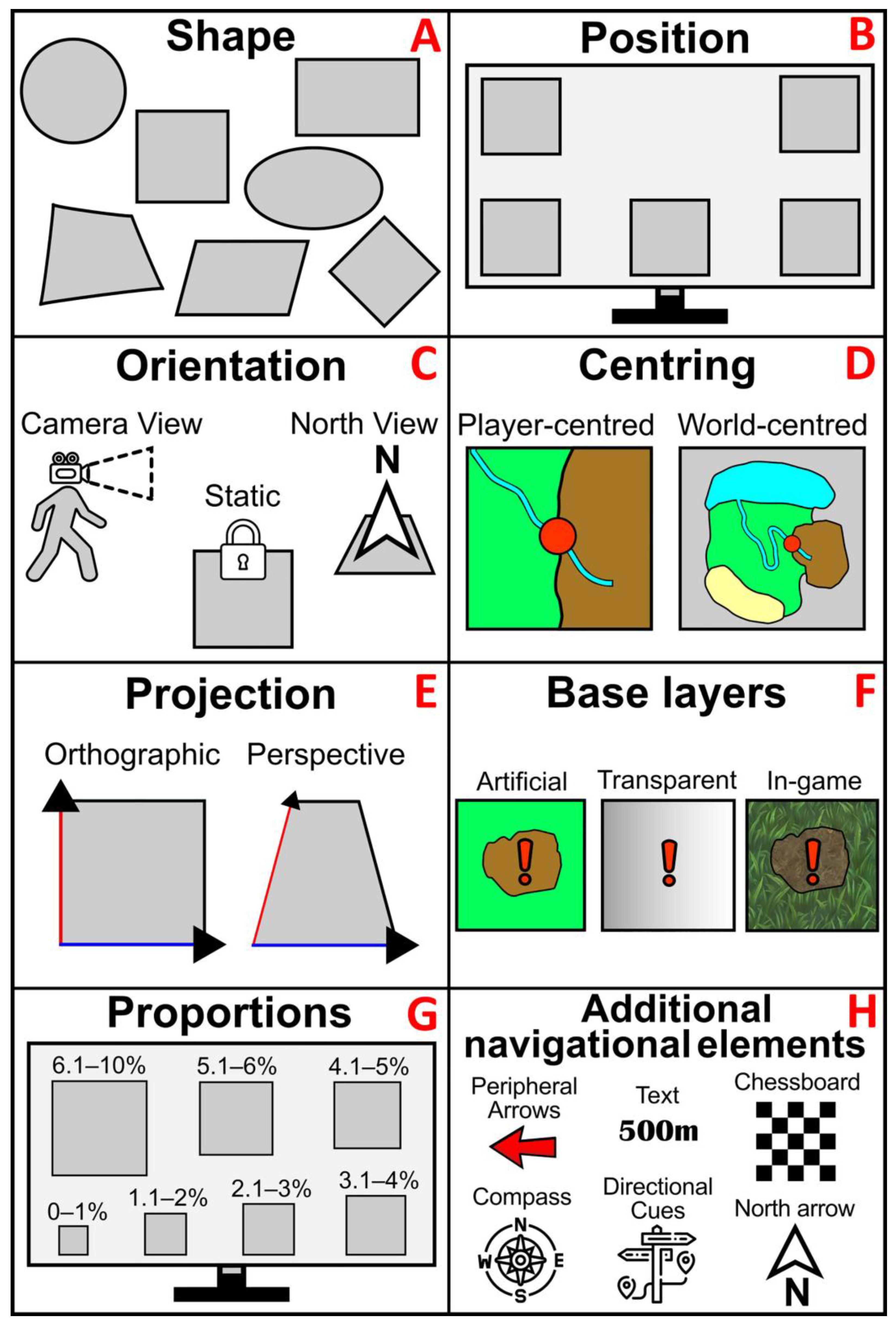
Based on the visual analysis of the chosen 100 video game interfaces, the following parameters and attributes were classified for the selected 8 features of the mini-map (Figure 2):
- Shape divided into 7 parameters: circle, irregular, rectangle, diamond, parallelogram, square and ellipse (Figure 2A).
- Position of the mini-map on the user interface in 5 basic parameters of placement: top left, top right, bottom left, bottom centre, bottom right (Figure 2B).
- Orientation of the mini-map to the game environment: camera view (rotation of the mini-map relative to the player’s camera during the game), north view (rotation of the mini-map relative to the north direction in the game) and static (no rotation of the mini-map) (Figure 2C).
- Mini-map centring: player-centred (only a limited field of view is represented, covering the player’s immediate surroundings) and world-centred (miniature map of the world) (Figure 2D).
- Projection: orthographic (top view) and perspective (oblique view) (Figure 2E).
- Base layers: artificial (with different textures than in the virtual geographical space), transparent (without spatial background or with artificial textures for important objects in the game) and in-game (textures as in virtual space) (Figure 2F).
- Proportions of the size of the mini-map and the whole game screen: 0–1%, 1.1–2%, 2.1–3%, 3.1–4%, 4.1–5%, 5.1–6%, 6.1–10% (Figure 2G).
- Additional navigational elements that support the mini-map to navigate in the virtual geographical space: chessboard, compass, directional cues, peripheral arrows, text and north arrow. This criterion took into account that a single video game may use several additional navigation elements (Figure 2H).
3. Results
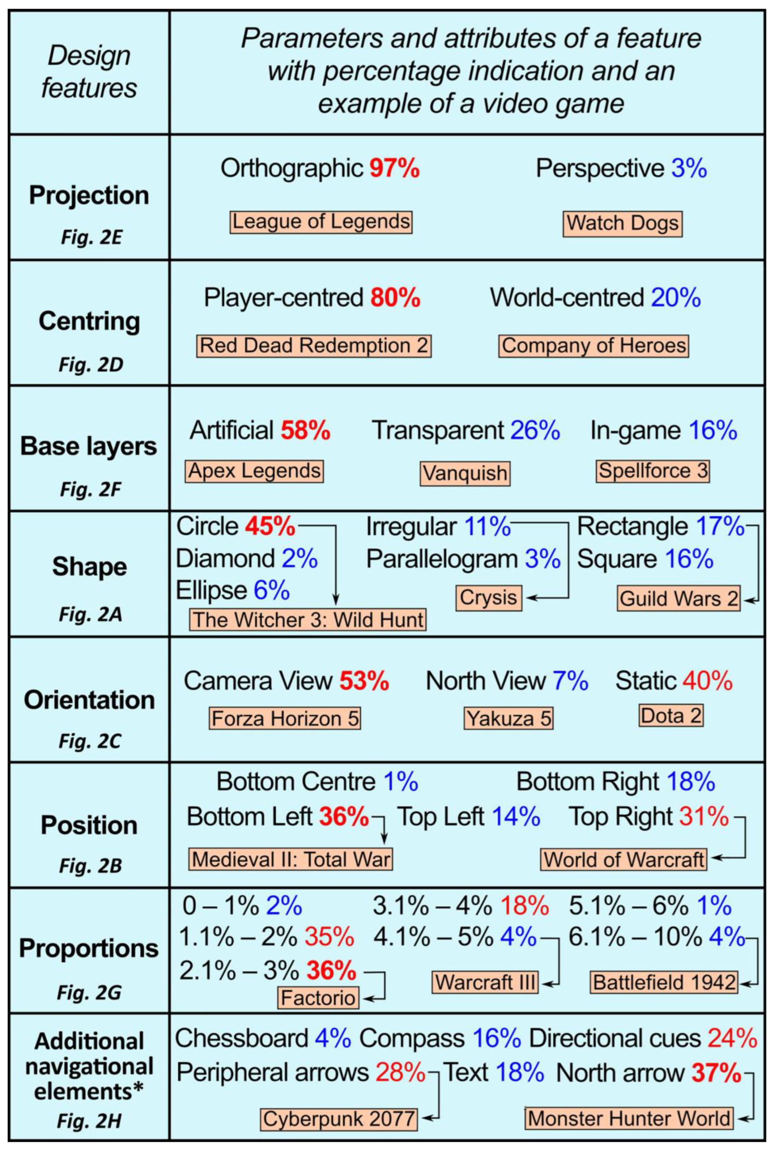
The analysis result in the juxtaposition form of mini-map features expressed as a percentage for each specific parameter or attribute is presented in Figure 3. The design features are listed in order from the first with the clearest indication of the preferred parameter (projection: orthographic 97%) to the last features with an unclear indication of the popularity of the parameters in the selected 100 video games.
3.1. Projection
Almost all video games used the mechanism of orthogonal projection in the mini-map to visualise the virtual world of the game (97%). Only 3% of the mini-maps used perspective projection to visualise the game space (Grand Theft Auto V, Forza Horizon 5, Watch Dogs).
3.2. Centring
The vast majority of mini-maps use the mechanism of a limited field of view covering the immediate surroundings of the player (80%). The predominant option is used especially in the genres RPG (role-playing game), MMORPG (massively multiplayer online role-playing game) and FPS (first-person shooter). Only 20% of the games choose the variant of a miniature map of the virtual world. This type of mini-map was mainly found in the game genres MOBA (multiplayer online battle arena) and RTS (real-time strategy).
3.3. Base Layers
This feature is dominated by mini-maps in which artificial layered textures were used (58%). Secondly, video game developers opted for a transparent mini-map that only highlights the key elements of the game (26%). Most rarely, game developers used in-game textures of the virtual geographical space that reflected the actual view of the player’s camera (16%).
3.4. Shape
Most of the mini-maps (45%) are in the shape of a circle. They are followed by a rectangle (17%) and a square (16%). The least popular are unusual geometric shapes such as: irregular (11%), ellipse (6%), parallelogram (3%) and diamond (2%).
3.5. Orientation
In the case of the analysed video games, more than half chose to orient themselves to the player’s camera (53%). Static orientation is second (40%) and orientation to the north of the virtual geographical space is the least common (7%).
3.6. Position
Holzinger et al. [78] noted that user interface elements embedded on the left side of the screen performed better than those on the right side. On the other hand, Edler et al. [79] showed in their study that the legend of the thematic map placed on the right side is read and decoded much faster than the legend on the left side. The analysis shows that the most frequently chosen position for a mini-map in the user interface is “bottom left” (36%). The next choice of developers was “top right” (31%), while the option “bottom centre” was only used in one game (1%). It can be seen that the split between the left side of the mini-map (50%) and the right side (49%) is insignificant.
3.7. Proportions
For the criterion of the size of the mini-map, the range of 2.1–3% (36%) in relation to the entire screen displayed was chosen most frequently. The size options 1.1–2% (35%) and 3.1–4% (18%) were also frequently chosen. The smallest size range 0–1% (2%) and mini-maps covering a larger area of the screen: 4.1–5% (4%), 5.1–6% (1%), 6.1–10% (4%) were used least frequently.
3.8. Additional Navigational Elements
Each game can have more than one additional navigational element on the user interface (mini-map is the main navigational element). Four-fifths of the video games have additional navigational elements besides the mini-maps to help the player find his way around the virtual geographical space (80%). The most popular navigational element is the north arrow, which points north in space (37%). Slightly less often, developers used peripheral arrows to indicate the destination (28%). The implementation of directional cues in the game was seen comparatively often (24%). The use of text elements was seen in 18% of games to increase the accuracy of navigation, while a compass element was introduced in 16% of games. Occasionally, a chessboard mechanism was added to the mini-map to better distinguish individual areas of the virtual world (4%).
3.9. Mini-Map Composition
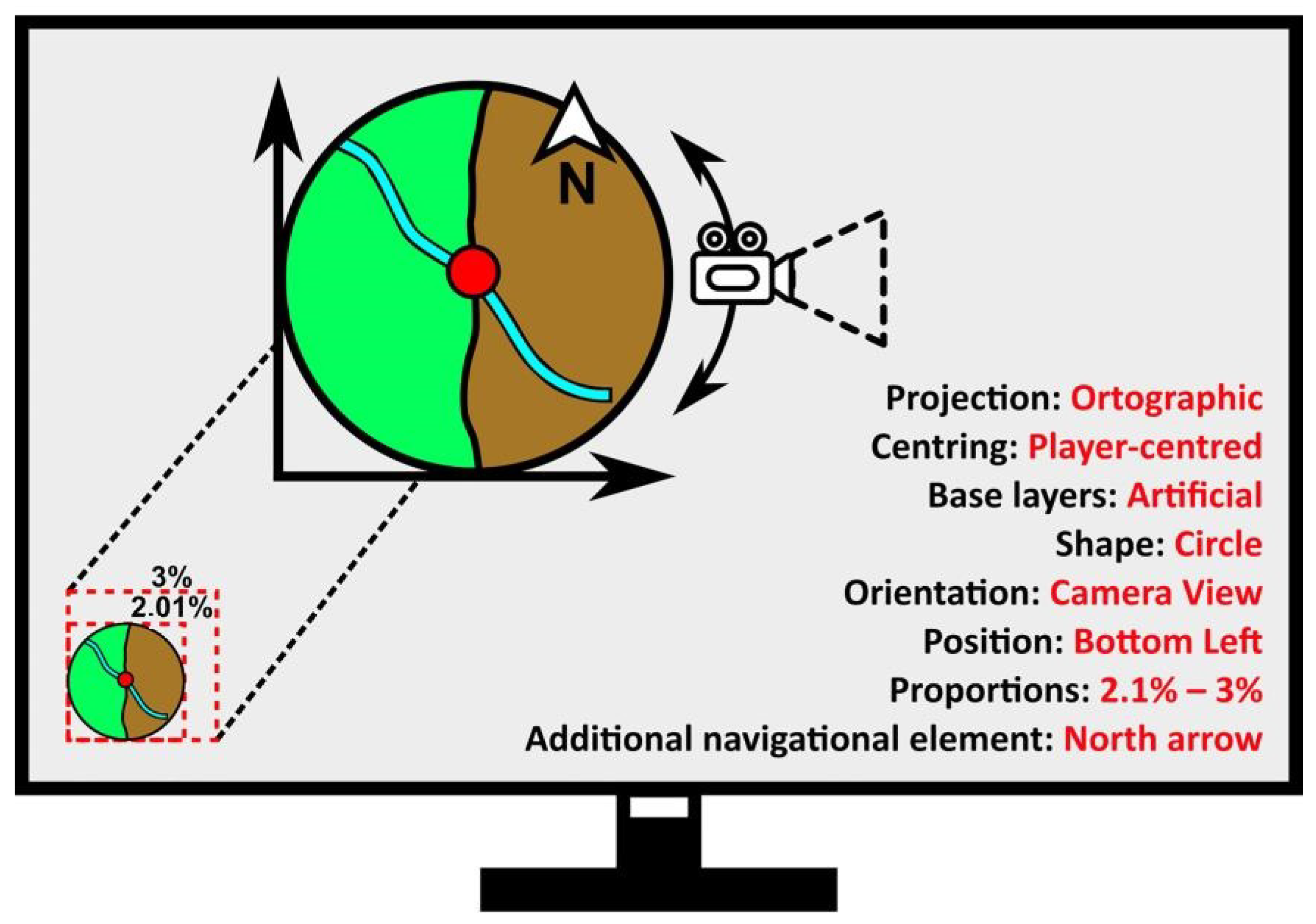
Figure 4 shows a graphical representation of the most popular attributes from eight mini-map design features. The composition is the result of the percentage rating of the parameters calculated separately for each feature from Figure 3. Therefore, it can be assumed that the features should meet the following popular parameters: projection: orthographic; centring: player-centred; base layers: artificial; shape: circle; orientation: camera view; position: bottom left; proportions: 2.1–3%; additional navigational element: north arrow. It is particularly noteworthy that only one mini-map from Assassin’s Creed IV: Black Flag meets the above-mentioned parameters of all eight mini-map features (Figure 4).
4. Discussion
Basic geometric shapes, such as a rectangle and a square, are usually used in designing shapes for traditional maps for navigation. The mini-map as a cartographic interface element in video games breaks with the basic principles of cartographic design by preferred use of the circle shape. Such a design of the mini-map by the game developers could be due to the fact that the shape of the circle often fits better with the graphic aesthetics of the game. The authors note an additional functionality of the shape described, as it allows symmetrical distance to be shown in any direction of the displayed space.
With regard to the position feature, the lower left corner of the screen proved to be the most frequent choice of the developers in designing the position of the mini-map. As a result of the analysis, a slight tendency to place the mini-map element at the bottom of the screen can be identified. Traditional cartographic design principles also suggest placing location maps below the main cartographic content.
The orientation, centring and projection features support the interaction between the player and the user interface. The continuous rotation of the mini-map in relation to the movement of the virtual character’s camera, the display of the player’s current position together with the immediate surroundings and the orthogonal projection onto the plane of the geographical space support the player in permanent topographical orientation.
As with the design of traditional topographic maps, game developers usually opt for an artificial texture layer that is distinct from the referenced geographical space. The graphic process aims to develop a pattern of navigational behaviour that enhances the interpretation of topographic objects in virtual geographic space.
The vast majority of video games favour smaller mini-maps with an aspect ratio of 1.1% to 3% of the total game screen. It can be assumed that the creators of these games intended the mini-map to play the role of an additional navigation option that enables orientation in virtual space. Even in traditional cartography, the location map is relatively small compared to the frame of the main content of the cartography.
When designing a complex navigation system, game developers do not limit themselves to individual interface elements. As the results of the analysis show, in addition to the mini-map, the developers often use other additional elements that are familiar to users from everyday life (north arrow or compass). It is worth mentioning that the above-mentioned elements are always a fixed part of the interface during the game. However, many games also use dynamic navigational elements that depend on current events or phenomena in the virtual geographical space (different types of lines or highlighted symbols).
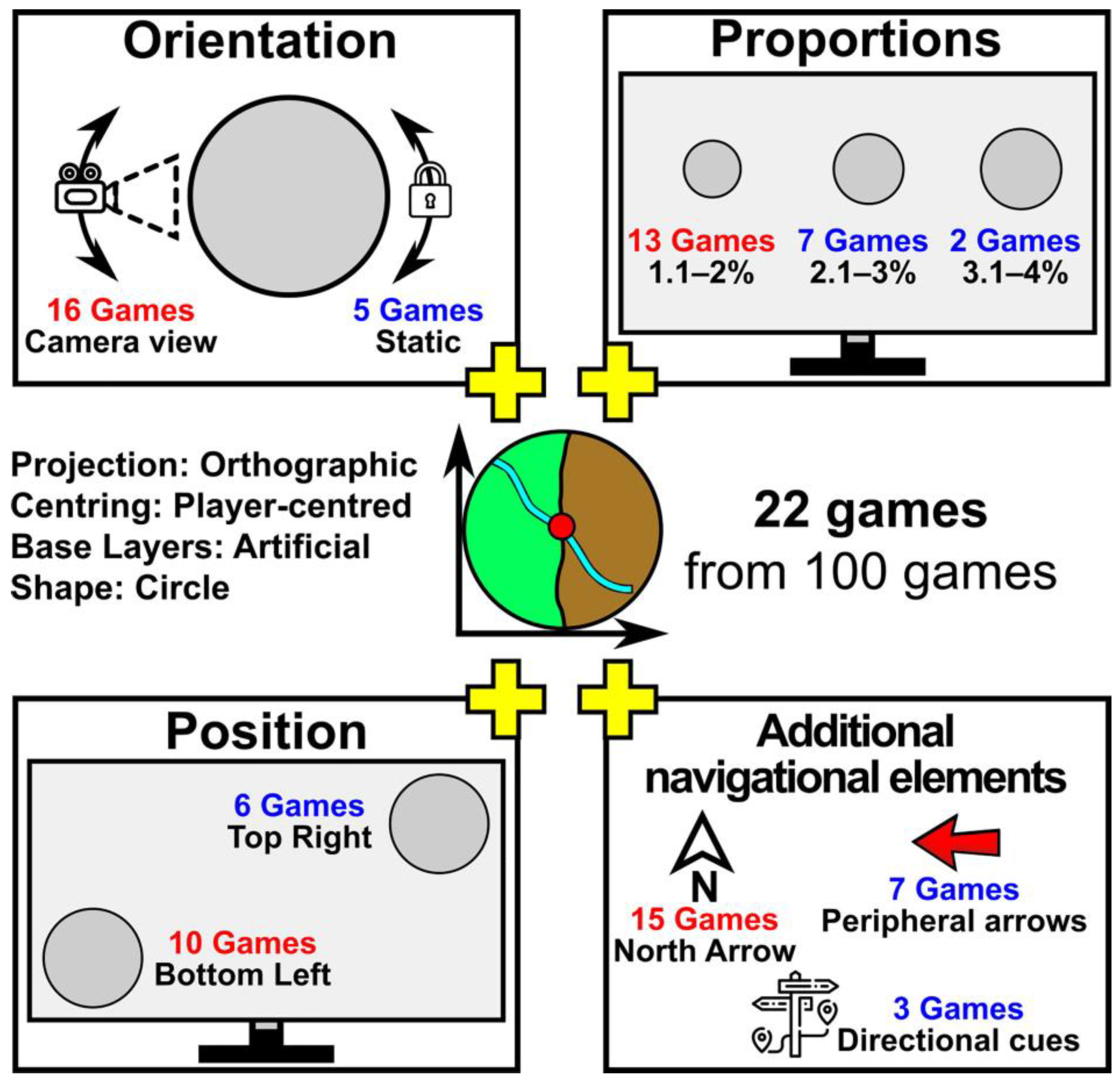
The unexpected fact of the research that all eight parameters are fulfilled with the highest percentages by only one game gives rise to a discussion about the complementarity and holistic nature of the design process in the context of the analysis of mini-map features [80]. Therefore, the authors draw attention to the possibility of grouping several selected features instead of treating all eight features of the mini-map together. Based on the comparison in Figure 3, four design features can be identified that have clearly defined priority parameters. Figure 5 shows the four most preferred parameters, which 22 out of 100 games fulfil: projection (orthographic), centring (player-centred), base layers (artificial) and shape (circle). The four features with the addition of camera view orientation implement mini-maps from 16 games, while the addition of the north arrow implements 15 selected video games. For the position feature, an unchanged trend of slightly more mini-maps in the lower left corner of the screen was noted (10 games). However, when identifying the four priority features, the proportion of smaller mini-maps is surprisingly much larger (13 games 1.1–2%).
5. Conclusions
In summary, the identification of mini-map design features in video games is very valuable for a navigational aid in the virtual geographical space. The authors focused on the selection and classification of the cartographic features of the mini-map element in the graphical user interface of video games in terms of the proposed parameters and attributes. The proposed research approach resulted in revealing eight features of mini-map design in video games, according to their most popular parameters and attributes: projection: orthographic; centring: player-centred; base layers: artificial; shape: circle; orientation: camera view; position: bottom left; proportions: 2.1–3%; additional navigational element: north arrow (Figure 3). If we interpret the mini-map features individually according to the popular parameters and attributes, we find that only one game fulfils all conditions (Figure 4). Based on the identification and arrangement of the eight mini-map features according to their individual parameters and attributes, we can conclude that the four most commonly used attributes are: orthographic projection, player-centred view, artificial base layer, circle shape (Figure 5). The feature of mini-map position on the screen is the most difficult to define, as the bottom left and bottom right corners are similarly preferred and the other two corners also have high usability.
In response to the additional research objectives of the article, it can be stated that the fundamental elements of the mini-map most commonly found among video game designers were indicated (Figure 5). They form the core of the cartographic design of the mini-map, on which further research on other evaluation criteria can be based.
The authors captured key attributes for mini-map features that are considered separately, complementarily and as holistically as possible, confirming the nature of mini-map design as part of an individual creative process that can be supported by traditional cartographic design principles [81,82]. These studies also confirm the importance of map design in the context of usability, which goes hand in hand with the popularity of cartographic products in new geomedia, such as mini-maps in video games [83].
The features analysed make the mini-map an important cartographic element in the visualisation of geographical space, providing detailed spatial information in a useful form. In general, the mini-map as the main element of the game cartography interface, is designed in accordance with the principles of cartographic design. The only significant divergency from the rules of map design is the use of a circle shape instead of a traditional rectangle. However, such a divergency is related to the specificity of navigation in virtual geographic space, which is the result of the necessary adaptation of cartographic design to new geomedia.
A navigation in spaces is not limited to virtual worlds, but takes place in all activities that have to do with moving around in our world. Cartographic elements in games, such as a mini-map, fulfil many conditions that can be compared to satellite applications on mobile phones [84]. The design of these elements usually varies according to the needs of presenting and exploring the geographical space. Fundamentally, they have a common task, which is to help people navigate through real or virtual spaces. Further research should include the possibility of comparing the individual design processes to identify differences in functions and tasks.
The authors hope that the identified most popular parameters of the eight features can be useful not only in the design of video games, but also in other cartographic products dealing with virtual and augmented reality. User-centred design focuses on the needs of the player [85] and the needs of the map users [57,86]. Future projects will also need an evaluation of popular solutions by gamers and map users to determine which solutions actually work best and are not just the most popular. Given the growing interest in the video game industry worldwide, more research is needed on the optimisation and effectiveness of the user interface and cartographic products.
Author Contributions
Conceptualization, Krzysztof Zagata and Beata Medyńska-Gulij; methodology, Krzysztof Zagata; formal analysis, Krzysztof Zagata; resources, Krzysztof Zagata; writing—original draft preparation, Krzysztof Zagata and Beata Medyńska-Gulij; writing—review and editing, Krzysztof Zagata and Beata Medyńska-Gulij. All authors have read and agreed to the published version of the manuscript.
Funding
This research received no external funding.
Data Availability Statement
Not applicable.
Acknowledgments
This paper is the result of research on the mini-map in the interface based on the analysis of video games carried out within statutory research on the doctorate at the Department of Cartography and Geomatics, Faculty of Geographical and Geological Sciences, Doctoral School, Adam Mickiewicz University Poznań, Poland.
Conflicts of Interest
The authors declare no conflict of interest.
Appendix A
Alphabetical list of the 100 games with a mini-map by Name-Year-Genre:
Age of Empires II: HD Edition-2013-Strategy; Albion Online-2017-MMORPG; Anno 1404-2009-Strategy; Apex Legends-2019-Action; Assassin’s Creed IV: Black Flag-2013-Action; Battlefield 1942-2002-Action; Battlefield 2-2005-Action; Battlefield 2042-2021-Action; Black Desert Online-2014-MMORPG; Borderlands 2-2012-Action; Call of Duty 4: Modern Warfare-2007-Action; Call of Duty: Black Ops-2010-Action; Call of Duty: Warzone-2020-Action; Company of Heroes-2006-Strategy; Company of Heroes 2-2013-Strategy; Cossacks 3-2016-Strategy; Counter-Strike: Global Offensive-2012-Action; Counter-Strike: Source-2005-Action; Crackdown 3-2019-Action; Crysis-2007-Action; Cyberpunk 2077-2020-Action; Darksiders 2-2012-Action; Days Gone-2021-Action; Dead Cells-2018-Platform; Dead Island-2011-Action; Dead Rising 4-2016-Action; Dekaron-2007-MMORPG; Destiny 2-2017-Action; Deus EX: Human Revolution-2011-RPG; Divinity: Original Sin II-2017-RPG; Dota 2-2013-MOBA; Dragon Age: Origins-2009-RPG; DRAGON QUEST XI S: Echoes of an Elusive Age—Definitive Edition-2018-RPG; Dying Light-2015-Action; Elex-2017-RPG; Factorio-2020-Strategy; Far Cry 3-2012-Action; Far Cry 4-2014-Action; Fifa 22-2021-Sports; Final Fantasy XII: The Zodiac Age-2018-RPG; Final Fantasy XIV-2013-MMORPG; For Honor-2017-Action; Fortnite-2017-Action; Forza Horizon 5-2021-Racing; Genshin Impact-2020-RPG; Grand Theft Auto III-2002-Action; Grand Theft Auto V-2015-Action; Grand Theft Auto: San Andreas-2005-Action; Grand Theft Auto: Vice City-2003-Action; Grim Dawn-2016-RPG; Guild Wars-2005-MMORPG; Guild Wars 2-2012-MMORPG; Heroes of Might and Magic III-2004-Strategy; Hitman 3-2021-Action; L.A. Noire-2011-Adventure; League of Legends-2009-MOBA; Lost Ark-2022-MMORPG; Mad Max-2015-Action; Medal of Honor-2010-Action; Medieval II: Total War-2006-Strategy; Middle-earth: Shadow of War-2017-Action; Monster Hunter World-2018-RPG; Need for Speed Payback-2017-Racing; Nioh-2017-RPG; Northgard-2018-Strategy; Orcs Must Die! 2-2012-Action; Path of Exile-2013-MMORPG; PlayerUnknown’s Battlegrounds-2017-Action; Red Dead Redemption 2-2019-Action; Rome: Total War-2004-Strategy; RuneScape-2003-MMORPG; S.T.A.L.K.E.R.: Call of Pripyat-2009-Action; Saints Row 4-2013-Action; Sleeping Dogs-2012-Action; Sniper Elite 4-2017-Action; Sniper: Ghost Warrior 3-2017-Action; Spellforce 3-2017-Strategy; Star Wars: Knights of the Old Republic-2003-RPG; Star Wars: The Old Republic-2011-MMORPG; Starcraft II: Wings of Liberty-2010-Strategy; The Ascent-2021-RPG; The Binding of Isaac: Afterbirth-2015-Action; The Crew 2-2018-Racing; The Riftbreaker-2021-Action; The Witcher 2: Assassins of Kings-2011-RPG; The Witcher 3: Wild Hunt-2015-RPG; Titanfall 2-2016-Action; Tom Clancy’s Ghost Recon: Wildlands-2017-Action; Torchlight 2-2012-RPG; Total War: Shogun 2-2011-Strategy; Valheim-2021-Action; Valorant-2020-Action; Vanquish-2017-Action; Warcraft III: The Frozen Throne-2003-Strategy; Warframe-2013-Action; Warhammer 40,000: Dawn of War—Dark Crusade-2006-Strategy; Watch Dogs-2014-Action; World of Tanks-2010-Action; World of Warcraft-2004-MMORPG; Yakuza 5 Remastered-2021-Action.
References
- Ash, J.; Gallacher, L.A. Cultural Geography and Videogames. Geogr. Compass 2011, 5, 351–368. [Google Scholar] [CrossRef]
- Behnke, M.; Gross, J.J.; Kaczmarek, L.D. The role of emotions in esports performance. Emotion 2022, 22, 1059–1070. [Google Scholar] [CrossRef] [PubMed]
- Wolf, M. 3 Space in the Video Game. In The Medium of the Video Game; Wolf, M., Ed.; University of Texas Press: New York, NY, USA, 2021. [Google Scholar]
- Coulton, P.; Huck, J.; Gradinar, A.; Salinas, L. Mapping the beach beneath the street: Digital cartography for the playable city. In Playable Cities. The City as Digital Playground; Nijholt, A., Ed.; Springer: Singapore, 2017. [Google Scholar]
- Horbiński, T.; Zagata, K. View of Cartography in Video Games: Literature Review and Examples of Specific Solutions. KN J. Cartogr. Geogr. Inf. 2022, 72, 117–128. [Google Scholar] [CrossRef]
- Lammes, S. Spatial Regimes of the Digital Playground: Cultural Functions of Spatial Practices in Computer Games. Space Cult. 2008, 11, 260–272. [Google Scholar] [CrossRef]
- Medyńska-Gulij, B. Kartografia I Geomedia; Wydawnictwo Naukowe PWN: Warsaw, Poland, 2021; ISBN 978-83-01-21554-5. [Google Scholar]
- Eskidemir, K.; Kubat, A.S. The visual structure of fictional space in video games: A wayfinding research in games based on real world cities. In Annual Conference Proceedings of the XXVIII International Seminar on Urban Form, Glasgow, UK, 29 June–3 July 2021; University of Strathclyde Publishing: Glasgow, UK, 2022. [Google Scholar]
- Johanson, C.; Gutwin, C.; Mandryk, R.L. The Effects of Navigation Assistance on Spatial Learning and Performance in a 3D Game. In Proceedings of the Annual Symposium on Computer-Human Interaction in Play (CHI PLAY 17), Amsterdam, The Netherlands, 15–18 October 2017; Association for Computing Machinery: New York, NY, USA, 2017; pp. 341–353. [Google Scholar]
- Ratajski, L. Logiczno-semiotyczne zasady porządkowania i standaryzacji znaków kartograficznych. Pol. Przegląd Kartogr. 1971, 3, 106–116. [Google Scholar]
- Bertin, J. Semiology of Graphics: Diagrams; University of Wisconsin Press: Madison, WI, USA, 1983. [Google Scholar]
- Medyńska-Gulij, B. Map compiling, map reading and cartographic design in “Pragmatic pyramid of thematic mapping”. Quaest. Geogr. 2010, 29, 57–63. [Google Scholar] [CrossRef]
- Horbiński, T.; Zagata, K. Map Symbols in Video Games: The Example of “Valheim”. KN J. Cartogr. Geogr. Inf. 2021, 71, 269–283. [Google Scholar] [CrossRef]
- Lammes, S. Terra Incognita: Computer Games, Cartography and Spatial Stories. In Digital Material: Tracing New Media in Everyday Life and Technology; Van Den Boomen, M., Lammes, S., Eds.; Amsterdam University Press: Amsterdam, The Netherlands, 2009; pp. 223–238. [Google Scholar]
- Ouriques, L.; Xexéo, G.; Mangeli, E. Analyzing Space Dimensions in Video Games. In Proceedings of the XVIII SBGames 2019, Rio de Janeiro, Brazil, 28–31 October 2019; IEEE: New York, NY, USA, 2019. [Google Scholar]
- Britta, N. World and Place: Map and Territory. In Proceedings of the DiGRA 2009 ‘Breaking New Ground: Innovation in Games, Play, Practice and Theory’, London, UK, 1–4 September 2009. [Google Scholar]
- Mat Zain, N.H.; Abdul Razak, F.H.; Jaafar, A.; Zulkipli, M.F. Eye Tracking in Educational Games Environment: Evaluating User Interface Design through Eye Tracking Patterns. In Proceedings of the Visual Informatics: Sustaining Research and Innovations, Selangor, Malaysia, 9–11 November 2011; Springer: Berlin/Heidelberg, Germany, 2011; pp. 64–73. [Google Scholar]
- Khan, N.; Rahman, A.U. Rethinking the Mini-Map: A Navigational Aid to Support Spatial Learning in Urban Game Environments. Int. J. Hum. Comput. Interact. 2018, 34, 1135–1147. [Google Scholar]
- Toups, Z.O.; Lalone, N.; Alharthi, S.A.; Sharma, H.N.; Webb, A.M. Making Maps Available for Play: Analyzing the Design of Game Cartography Interfaces. ACM Trans. Comput. Hum. Interact. 2019, 26, 1–43. [Google Scholar] [CrossRef]
- Edler, D.; Husar, A.; Keil, J.; Vatter, M.; Dickmann, F. Virtual Reality (VR) and Open Source Software: A Workflow for Constructing an Interactive Cartographic VR Environment to Explore Urban Landscapes. J. Cartogr. Geogr. Inf. 2018, 68, 5–13. [Google Scholar] [CrossRef]
- Mahalil, I.; Yusof, A.M.; Ibrahim, N.; Mahidin, E.M.M.; Rusli, M.E. Virtual Reality Mini Map Presentation Techniques: Lessons and experience learned. In Proceedings of the 2019 IEEE Conference on Graphics and Media (GAME), Pulau Pinang, Malaysia, 19–21 November 2019; IEEE: New York, NY, USA, 2019; pp. 26–31. [Google Scholar]
- Peacocke, M.; Teather, R.J.; Carette, J.; MacKenzie, I.S.; McArthur, V. An empirical comparison of first-person shooter information displays: Huds diegetic displays and spatial representations. Entertain. Comput. 2018, 26, 41–58. [Google Scholar]
- Marre, Q.; Caroux, L.; Sakdavong, J.C. Video game interfaces and diegesis: The impact on experts and novices’ performance and experience in virtual reality. Int. J. Hum. Comput. Interact. 2021, 37, 1089–1103. [Google Scholar] [CrossRef]
- Couclelis, H. Space, Time, Geography. Geogr. Inf. Syst. 1999, 1, 29–38. [Google Scholar]
- Lin, H.; Jianhua, G. Exploring Virtual Geographic Environments. Geogr. Inf. Sci. 2001, 7, 1–7. [Google Scholar] [CrossRef]
- Mukherjee, S. The Playing Fields of Empire: Empire and Spatiality in Video Games. J. Gaming Virtual Worlds 2015, 7, 299–315. [Google Scholar] [CrossRef] [PubMed]
- Batty, M. Virtual geography. Futures 1997, 29, 337–352. [Google Scholar] [CrossRef]
- Konecny, M. Review: Cartography: Challenges and potential in the virtual geographical environments era. Ann. GIS 2011, 17, 135–146. [Google Scholar]
- Kraak, M.J.; Ormeling, F. Cartography: Visualization of Geospatial Data, 4th ed.; CRC Press: Boca Raton, FL, USA, 2020. [Google Scholar]
- Gekker, A. (Mini) Mapping the Game-Space. In Playful Mapping in the Digital Age (Theory on Demand Series); The Playful Mapping Collective, Ed.; Institute of Network Cultures: Amsterdam, The Netherlands, 2018. [Google Scholar]
- McGregor, G.L. Situations of Play: Patterns of Spatial Use in Videogames. In Proceedings of the 2007 DiGRA International Conference: Situated Play, Tokyo, Japan, 24–28 September 2007; Digital Games Research Association: Helsinki, Finland, 2007. [Google Scholar]
- Di Tore, P. Perception of Space, Empathy and Cognitive Processes: Design of a Video Game for the Measurement of Perspective Taking Skills. Int. J. Emerg. Technol. Learn. 2014, 9, 23–29. [Google Scholar]
- Si, C.; Pisan, Y.; Tan, C.T.; Shen, S. An initial understanding of how game users explore virtual environments. Entertain. Comput. 2017, 19, 13–27. [Google Scholar] [CrossRef]
- Davis, M.; Kent, A.J. Soviet City Plans and OpenStreetMap: A comparative analysis. Int. J. Cartogr. 2022. Available online: https://0-www-tandfonline-com.brum.beds.ac.uk/doi/pdf/10.1080/23729333.2022.2047396 (accessed on 30 September 2022).
- Schobesberger, D. Integrating User and Usability Research in Web-Mapping Application Design. In Modern Trends in Cartography; Brus, J., Vondrakova, A., Vozenilek, V., Eds.; Springer: Cham, Switzerland, 2014. [Google Scholar]
- Kuveždić Divjak, A.; Đapo, A.; Pribičević, B. Cartographic Symbology for Crisis Mapping: A Comparative Study. ISPRS Int. J. Geo. Inf. 2020, 9, 142. [Google Scholar]
- Cybulski, P. Design rules and practices for animated maps online. J. Spat. Sci. 2016, 61, 461–471. [Google Scholar]
- Medyńska-Gulij, B.; Wielebski, Ł.; Halik, Ł.; Smaczyński, M. Complexity Level of People Gathering Presentation on an Animated Map—Objective Effectiveness Versus Expert Opinion. ISPRS Int. J. Geo.Inf. 2020, 9, 117. [Google Scholar] [CrossRef]
- Medyńska-Gulij, B. Educating tomorrow’s cartographers. In The Routledge Handbook of Mapping and Cartography; Kent, A.J., Vujakovic, P., Eds.; Routledge: Milton Park, UK, 2018. [Google Scholar]
- Gazzard, A. Gaming maps and virtual words. In The Routledge Handbook of Mapping and Cartography; Kent, A.J., Vujakovic, P., Eds.; Routledge: Milton Park, UK, 2018. [Google Scholar]
- Johnson, D.; Wiles, J. Effective affective user interface design in games. Ergonomics 2003, 46, 1332–1345. [Google Scholar] [CrossRef] [PubMed]
- Toups, Z.O.; LaLone, N.; Spiel, K.; Hamilton, B. Paper to Pixels: A Chronicle of Map Interfaces in Games. In Proceedings of the 2020 ACM Designing Interactive Systems Conference (DIS 20), Eindhoven, The Netherlands, 6–10 July 2020; Association for Computing Machinery: New York, NY, USA, 2020. [Google Scholar]
- Juul, J.; Norton, M. Easy to use and incredibly difficult: On the mythical border between interface and gameplay. In Proceedings of the 4th International Conference on Foundations of Digital Games (FDG 2009), Orlando, FL, USA, 26–30 April 2009; Association for Computing Machinery: New York, NY, USA, 2009; pp. 107–112. [Google Scholar]
- Miraz, M.H.; Excell, P.S.; Ali, M. User interface (UI) design issues for multilingual users: A case study. Univers. Access Inf. Soc. 2016, 15, 431–444. [Google Scholar]
- Callahan, E. Interface design and culture. Annu. Rev. Inf. Sci. Technol. 2006, 39, 255–310. [Google Scholar]
- Horbiński, T.; Cybulski, P.; Medyńska-Gulij, B. Graphic Design and Button Placement for Mobile Map Applications. Cartogr. J. 2020, 57, 196–208. [Google Scholar] [CrossRef]
- Slocum, T.; McMaster, R.B.; Kessler, F.C.; Howard, H.H. Thematic Cartography and Geographic Visualization, 2nd ed.; Pearson Prentice Hall: Upper Saddle River, NJ, USA, 2005. [Google Scholar]
- Hayatpur, D.; Xia, H.; Wigdor, D. DataHop: Spatial Data Exploration in Virtual Reality. In Proceedings of the 33rd Annual ACM Symposium on User Interface Software and Technology (UIST 2020), virtual event, USA, 20–23 October 2020; Association for Computing Machinery: New York, NY, USA, 2020; pp. 818–828. [Google Scholar]
- Okada, A.; Rocha, K.; Fuchter, S.; Zucchi, S.; Wortley, D. Formative assessment of inquiry skills for Responsible Research and Innovation using 3D Virtual Reality Glasses and Face Recognition. In Proceedings of the Technology Enhanced Assessment Conference (TEA 2018), Hong Kong, 8–9 February 2018; Springer: Berlin, Germany, 2019; pp. 91–101. [Google Scholar]
- Adams, E. Fundamentals of Game Design, 3rd ed.; New Riders Publishing: Indianapolis, IN, USA, 2014. [Google Scholar]
- Horbiński, T.; Zagata, K. Interpretation of Map Symbols in the Context of Gamers’ Age and Experience. ISPRS Int. J. Geo-Inf. 2022, 11, 150. [Google Scholar] [CrossRef]
- Zagata, K.; Gulij, J.; Halik, Ł.; Medyńska-Gulij, B. Mini-Map for Gamers Who Walk and Teleport in a Virtual Stronghold. ISPRS Int. J. Geo-Inf. 2021, 10, 96. [Google Scholar]
- Nesbitt, K.; Sutton, K.; Wilson, J.; Hookham, G. Improving player spatial abilities for 3D challenges. In Proceedings of the Sixth Australasian Conference on Interactive Entertainment (IE 2009), Sydney, Australia, 17–19 December 2009; Association for Computing Machinery: New York, NY, USA, 2009. [Google Scholar]
- Edler, D.; Keil, J.; Wiedenlübbert, T.; Sossna, M.; Kühne, O.; Dickmann, F. Immersive VR Experience of Redeveloped Post-industrial Sites: The Example of “Zeche Holland” in Bochum-Wattenscheid. KN J. Cartogr. Geogr. Inf. 2019, 69, 267–284. [Google Scholar]
- Edler, D.; Keil, J.; Dickmann, F. Varianten interaktiver Karten in Video-und Computerspielen—Eine Übersicht. KN J. Cartogr. Geogr. Inf. 2018, 68, 57–65. [Google Scholar] [CrossRef]
- Fadaeddini, A.; Majidi, B.; Eshghi, M. A Case Study of Generative Adversarial Networks for Procedural Synthesis of Original Textures in Video Games. In Proceedings of the 2nd National and 1st International Digital Games Research Conference: Trends, Technologies, and Applications (DGRC 2018), Tehran, Iran, 29–30 November 2018; Institute of Electrical and Electronics Engineers: New York, NY, USA, 2018; pp. 118–122. [Google Scholar]
- Medyńska-Gulij, B.; Zagata, K. Experts and Gamers on Immersion into Reconstructed Strongholds. ISPRS Int. J. Geo-Inf. 2020, 9, 655. [Google Scholar] [CrossRef]
- Wiemer, S. Interface Analysis: Notes on the “Scopic Regime” of Strategic Action in Real-Time Strategy Games. In Computer Games and New Media Cultures; Fromme, J., Unger, A., Eds.; Springer: Dordrecht, The Netherlands, 2012. [Google Scholar]
- Burigat, S.; Chittaro, L. Navigation in 3D virtual environments: Effects of user experience and location-pointing navigation aids. Int. J. Hum. Comput. Stud. 2007, 65, 945–958. [Google Scholar] [CrossRef]
- Novak, J. Game Development Essentials: An Introduction, 3rd ed.; Cengage Learning: Boston, MA, USA, 2011; ISBN 9781111307653. [Google Scholar]
- Targett, S.; Verlysdonk, V.; Hamilton, H.J.; Hepting, D. A study of user interface modifications in World of Warcraft. Game Stud. 2012, 12. Available online: https://www.researchgate.net/publication/290732545_A_Study_of_User_Interface_Modifications_in_World_of_Warcraft (accessed on 30 September 2022).
- Su, A.J.; Hu, Y.C.; Kuzmanovic, A.; Koh, C.K. How to improve your search engine ranking: Myths and reality. ACM Trans. Web 2014, 8, 1–25. [Google Scholar] [CrossRef]
- IGN. Top 100 Video Games of All Time. Available online: https://www.ign.com/lists/top-100-games/100 (accessed on 17 January 2022).
- GryOnline. Najlepsze Gry Wszech Czasów. Available online: https://www.gry-online.pl/ranking-gier.asp?CZA=2 (accessed on 17 January 2022).
- Slant Magazine. The 100 Best Video Games of All Time. Available online: https://www.slantmagazine.com/games/the-100-best-video-games-of-all-time/ (accessed on 17 January 2022).
- GAMINGbible. The Greatest Video Games Of All Time. Available online: https://www.gamingbible.co.uk/features/games-the-greatest-video-games-of-all-time-100-81-20201130 (accessed on 17 January 2022).
- Screenage Wasteland. The 500 Greatest Video Games of All Time (25-1). Available online: https://screenagewasteland.com/the-500-greatest-video-games-of-all-time-25-1/ (accessed on 18 January 2022).
- Rock Paper Shotgun Part 1. The RPS 100: Our Top PC Games of All Time (100-51). Available online: https://www.rockpapershotgun.com/the-rps-100-2021-part-one (accessed on 18 January 2022).
- Rock Paper Shotgun Part 2. The RPS 100: Our Top PC Games of All Time (50-1). Available online: https://www.rockpapershotgun.com/the-rps-100-2021-part-two (accessed on 18 January 2022).
- Tom’s Guide. The Best PC Games of 2023. Available online: https://www.tomsguide.com/best-picks/best-PC-games (accessed on 18 January 2022).
- ProFanboy. 25 Best PC Games of All Time. Available online: https://profanboy.com/best-pc-games/ (accessed on 18 January 2022).
- Metacritic. Available online: https://www.metacritic.com/browse/games/score/userscore/all/all/filtered?sort=desc (accessed on 18 January 2022).
- OpenCritic. Available online: https://opencritic.com/browse/all (accessed on 18 January 2022).
- Giant Bomb. Available online: https://www.giantbomb.com/profile/dantebk/lists/game-informers-top-200-games-of-all-time/32009/ (accessed on 19 January 2022).
- PC Gamer. The Top 100 PC Games. Available online: https://www.pcgamer.com/top-100-pc-games-2021/ (accessed on 19 January 2022).
- Popular Mechanics. The 100 Greatest Video Games of All Time. Available online: https://www.popularmechanics.com/culture/gaming/g134/the-100-greatest-video-games-of-all-time/ (accessed on 19 January 2022).
- Ranker. Available online: https://www.ranker.com/list/most-popular-pc-games-today/ranker-games (accessed on 19 January 2022).
- Holzinger, A.; Scherer, R.; Ziefle, M. Navigational User Interface Elements on the Left Side: Intuition of Designers or Experimental Evidence? In Human-Computer Interaction—INTERACT 2011; Campos, P., Graham, N., Jorge, J., Nunes, N., Palanque, P., Winckler, M., Eds.; Springer: Berlin/Heidelberg, Germany, 2011. [Google Scholar]
- Edler, D.; Keil, J.; Tuller, M.C.; Bestgen, A.K.; Dickmann, F. Searching for the ‘Right’ Legend: The Impact of Legend Position on Legend Decoding in a Cartographic Memory Task. Cartogr. J. 2018, 57, 6–17. [Google Scholar]
- Medyńska-Gulij, B. Geomedia Attributes for Perspective Visualization of Relief for Historical Non-Cartometric Water-Colored Topographic Maps. ISPRS Int. J. Geo-Inf. 2022, 11, 554. [Google Scholar] [CrossRef]
- Robinson, A.H.; Morrison, J.L.; Muehrecke, P.C.; Kimerling, A.J.; Guptil, S.C. Elements of Cartography, 6th ed.; Wiley: New York, NY, USA, 1995. [Google Scholar]
- Dent, B.D. Cartography: Thematic Map Design, 5th ed.; McGraw-Hill: Boston, CA, USA, 1998. [Google Scholar]
- Medyńska-Gulij, B.; Gulij, J.; Cybulski, P.; Zagata, K.; Zawadzki, J.; Horbiński, T. 2022, Map Design and Usability of a Simplified Topographic 2D Map on the Smartphone in Land-scape and Portrait Orientations. ISPRS Int. J. Geo-Inf. 2022, 11, 577. [Google Scholar]
- Chesher, C. Navigating Sociotechnical Spaces: Comparing Computer Games and Sat Navs as Digital Spatial Media. Converg. Int. J. Res. Into New Media Technol. 2012, 18, 315–330. [Google Scholar] [CrossRef]
- Chammas, A.; Quaresma, M.; Mont’Alvão, C. A closer look on the user centred design. Procedia Manuf. 2015, 3, 5397–5404. [Google Scholar]
- Kramers, E. Interaction with Maps on the Internet—A User Centred Design Approach for The Atlas of Canada. Cartogr. J. 2008, 45, 98–107. [Google Scholar]
Figure 1.
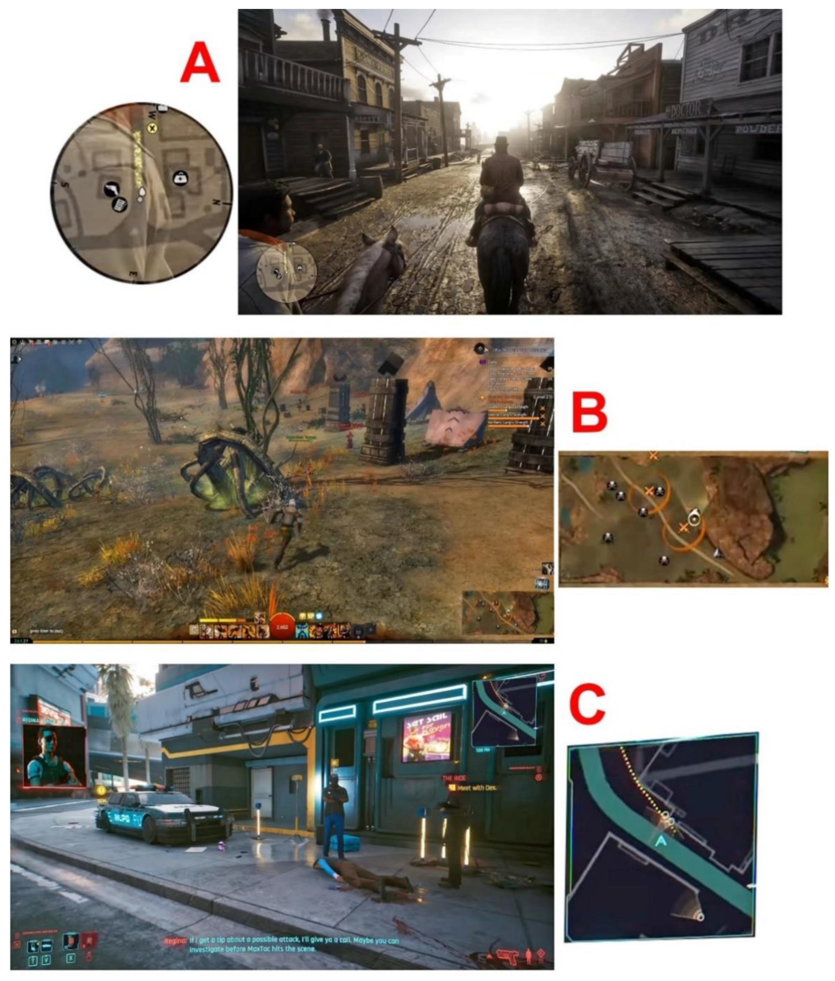
Examples of video games with a mini-map in the game cartography interface (A) Red Dead Redemption 2; (B) Guild Wars 2; (C) Cyberpunk 2077.
Figure 1.
Examples of video games with a mini-map in the game cartography interface (A) Red Dead Redemption 2; (B) Guild Wars 2; (C) Cyberpunk 2077.

Figure 2.
Parameters and attributes for 8 mini-map features according to the chosen 100 video games ((A) shape, (B) position, (C) orientation, (D) centring, (E) projection, (F) base layers, (G) proportions, (H) additional navigational elements).
Figure 2.
Parameters and attributes for 8 mini-map features according to the chosen 100 video games ((A) shape, (B) position, (C) orientation, (D) centring, (E) projection, (F) base layers, (G) proportions, (H) additional navigational elements).

Figure 3.
The percentage of use of a specific parameter of the mini-map with examples of video games according to their majority unambiguity. Bold red stands for the highest percentage, solid red for a value close to the highest, blue colour for values far from the highest. * One video game can use many additional navigational elements.

Figure 4.
Mini-map composition on the display view (16:9) with the most popular parameters of 8 design features—by separate analysis for each parameter.
Figure 4.
Mini-map composition on the display view (16:9) with the most popular parameters of 8 design features—by separate analysis for each parameter.

Figure 5.
Grouping of the most popular and preferred parameters of the mini-map features: projection, centring, base layers and shape with separate addition of other popular attributes or parameters from four other features (see Figure 3).
Figure 5.
Grouping of the most popular and preferred parameters of the mini-map features: projection, centring, base layers and shape with separate addition of other popular attributes or parameters from four other features (see Figure 3).

Disclaimer/Publisher’s Note: The statements, opinions and data contained in all publications are solely those of the individual author(s) and contributor(s) and not of MDPI and/or the editor(s). MDPI and/or the editor(s) disclaim responsibility for any injury to people or property resulting from any ideas, methods, instructions or products referred to in the content. |
© 2023 by the authors. Licensee MDPI, Basel, Switzerland. This article is an open access article distributed under the terms and conditions of the Creative Commons Attribution (CC BY) license (https://creativecommons.org/licenses/by/4.0/).
Share and Cite
MDPI and ACS Style
Zagata, K.; Medyńska-Gulij, B. Mini-Map Design Features as a Navigation Aid in the Virtual Geographical Space Based on Video Games. ISPRS Int. J. Geo-Inf. 2023, 12, 58. https://0-doi-org.brum.beds.ac.uk/10.3390/ijgi12020058
AMA Style
Zagata K, Medyńska-Gulij B. Mini-Map Design Features as a Navigation Aid in the Virtual Geographical Space Based on Video Games. ISPRS International Journal of Geo-Information. 2023; 12(2):58. https://0-doi-org.brum.beds.ac.uk/10.3390/ijgi12020058
Chicago/Turabian StyleZagata, Krzysztof, and Beata Medyńska-Gulij. 2023. "Mini-Map Design Features as a Navigation Aid in the Virtual Geographical Space Based on Video Games" ISPRS International Journal of Geo-Information 12, no. 2: 58. https://0-doi-org.brum.beds.ac.uk/10.3390/ijgi12020058
Note that from the first issue of 2016, this journal uses article numbers instead of page numbers. See further details here.