Examining Hotspots of Traffic Collisions and their Spatial Relationships with Land Use: A GIS-Based Geographically Weighted Regression Approach for Dammam, Saudi Arabia


Abstract
:1. Introduction
1.1. Road Safety in Kingdom of Saudi Arabia
1.2. Definition of Crash Hotspots
1.3. Existing Methods for Crash Hotspots Identification
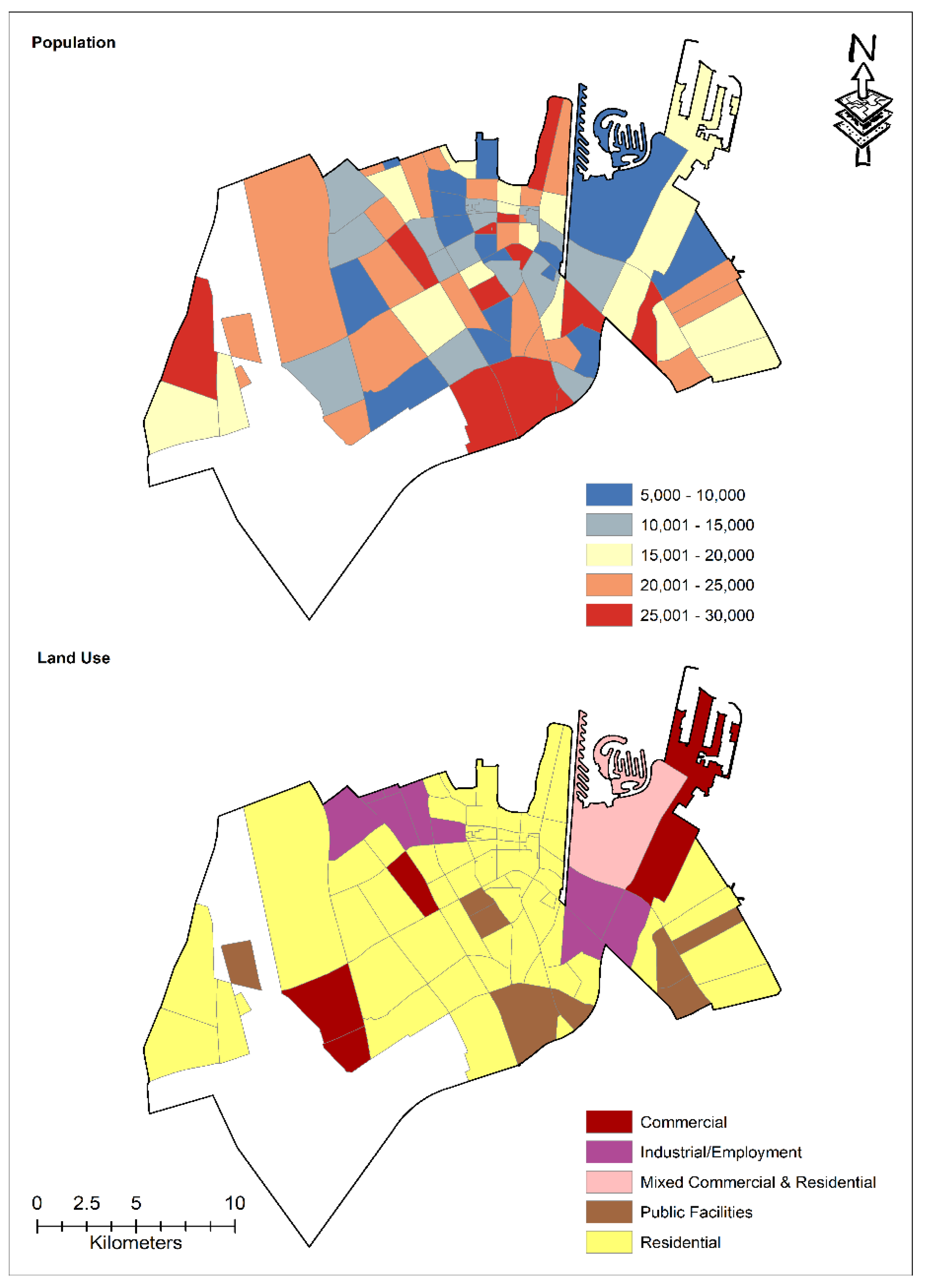
1.4. Relationship between Land Use and Crash Hotspots
1.5. Previous Studies for HSID Using GIS
1.6. Contributions of the Current Study
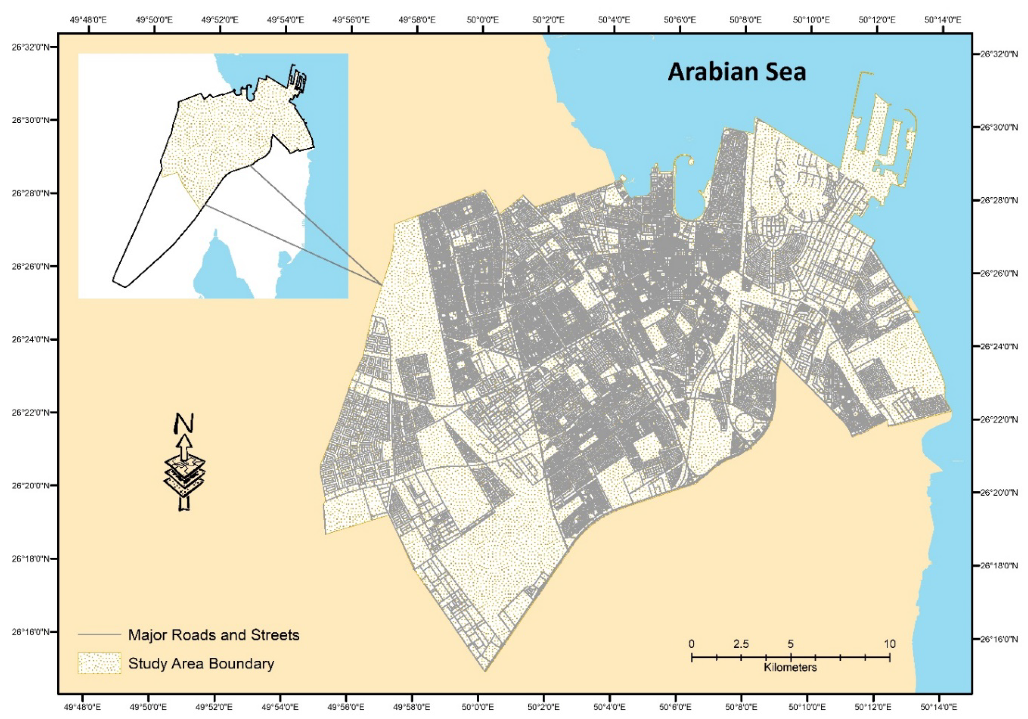
2. Study Area
3. Data and Methods
4. Results and Discussion
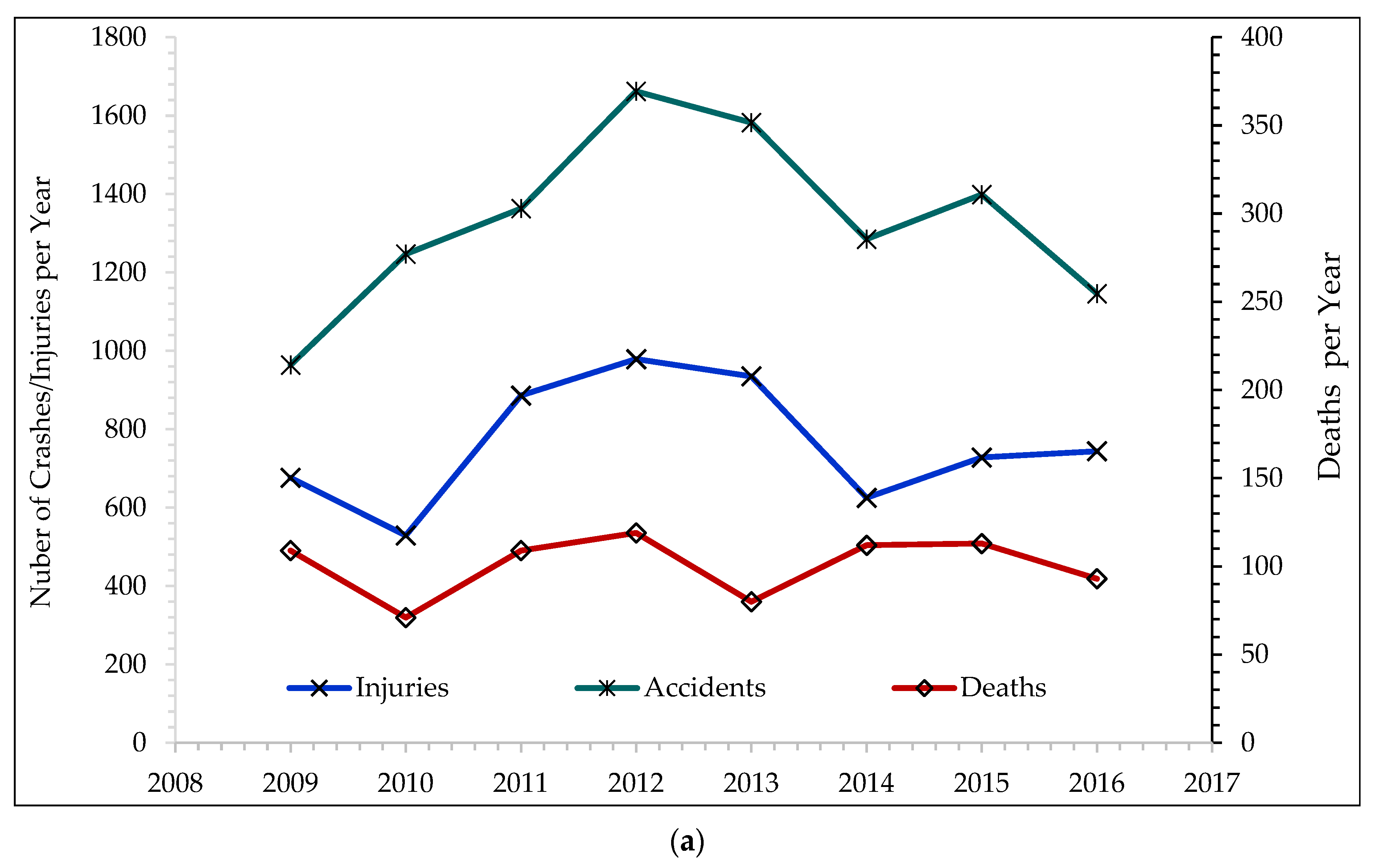
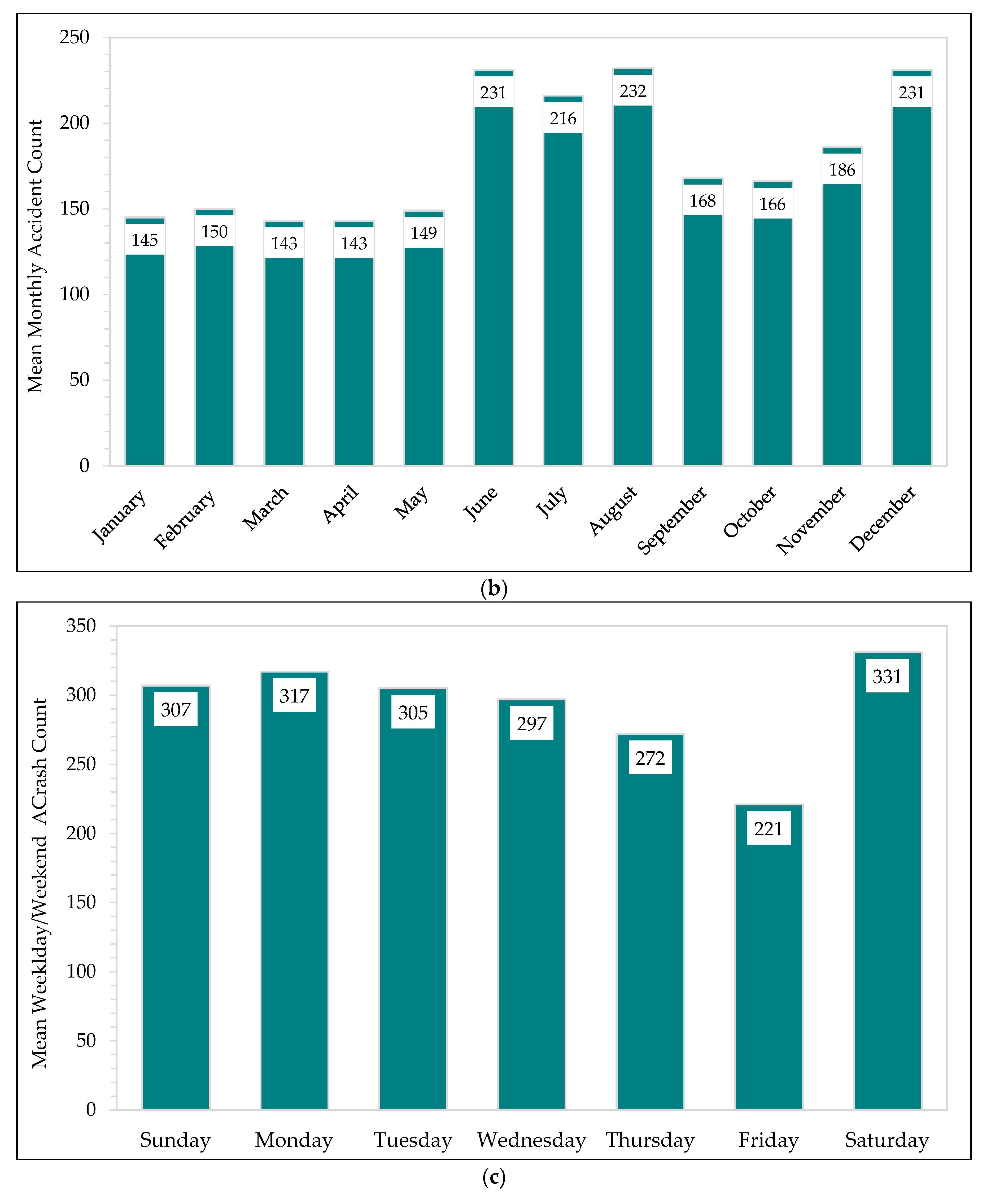
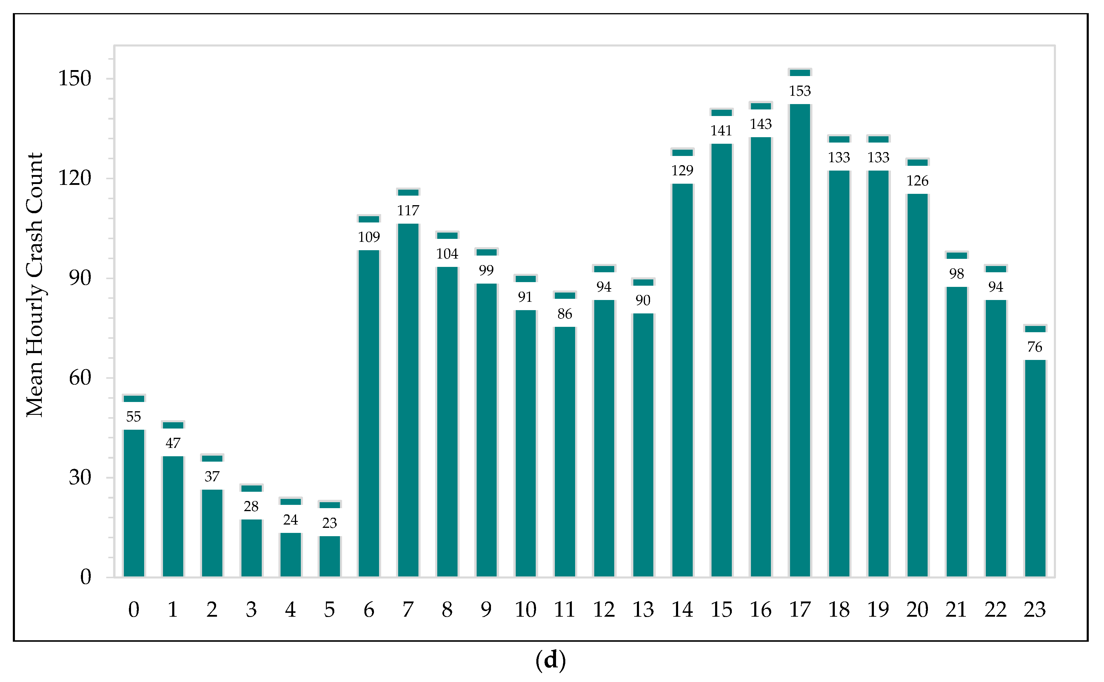
4.1. Temporal Distribution of Crashes
4.2. Crash Hotspot Analysis
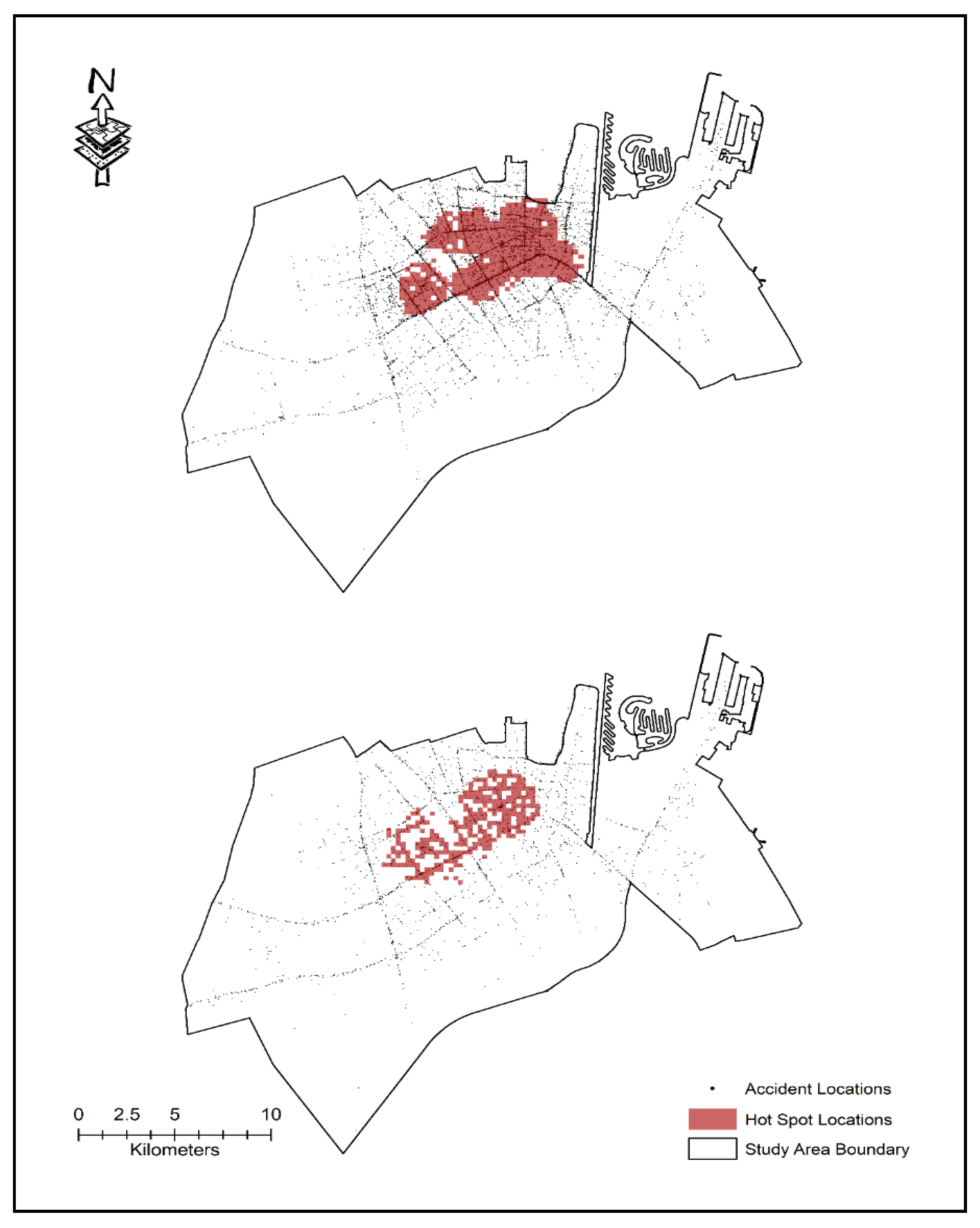
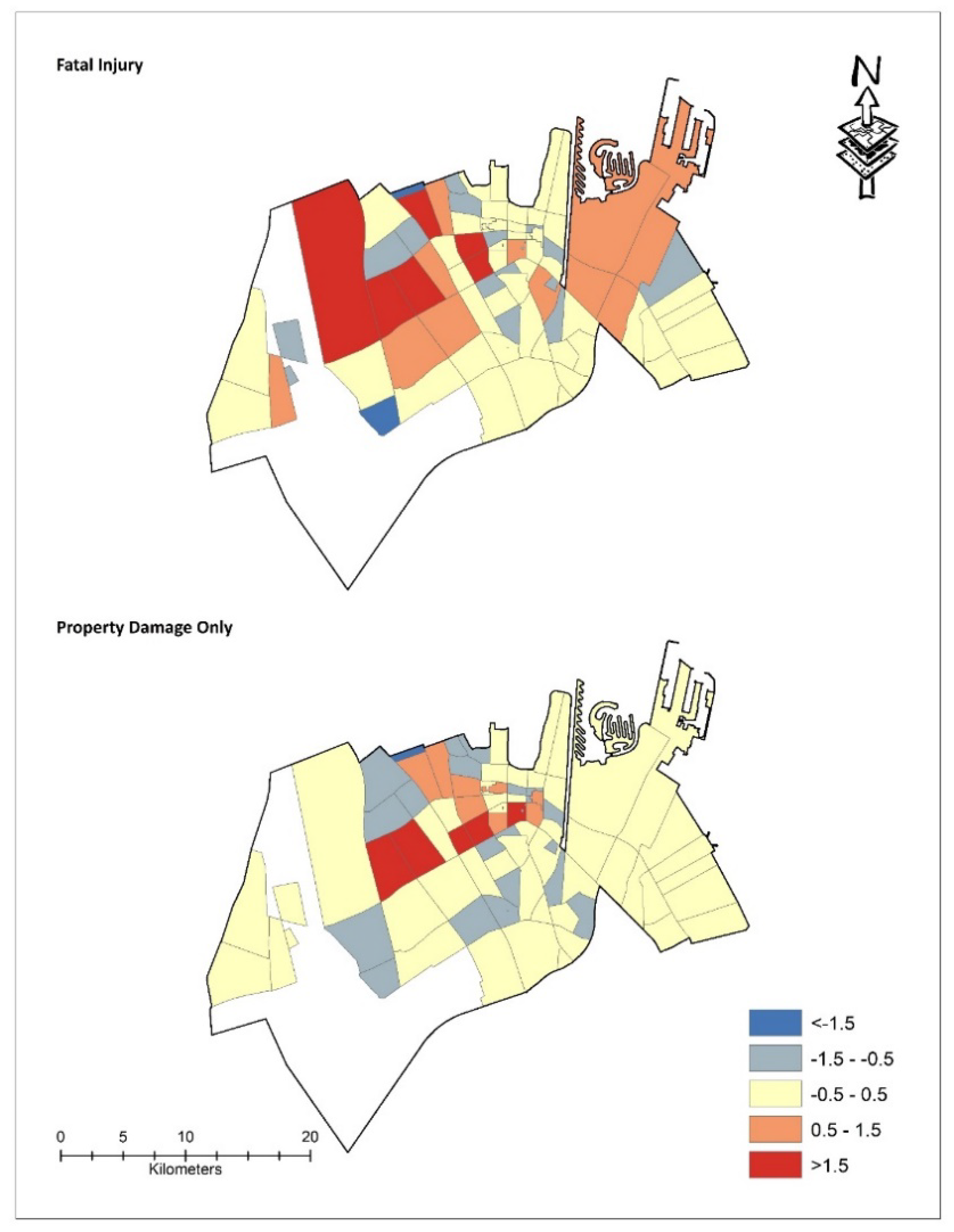
4.2.1. Hotspot Analysis by Crash Severity
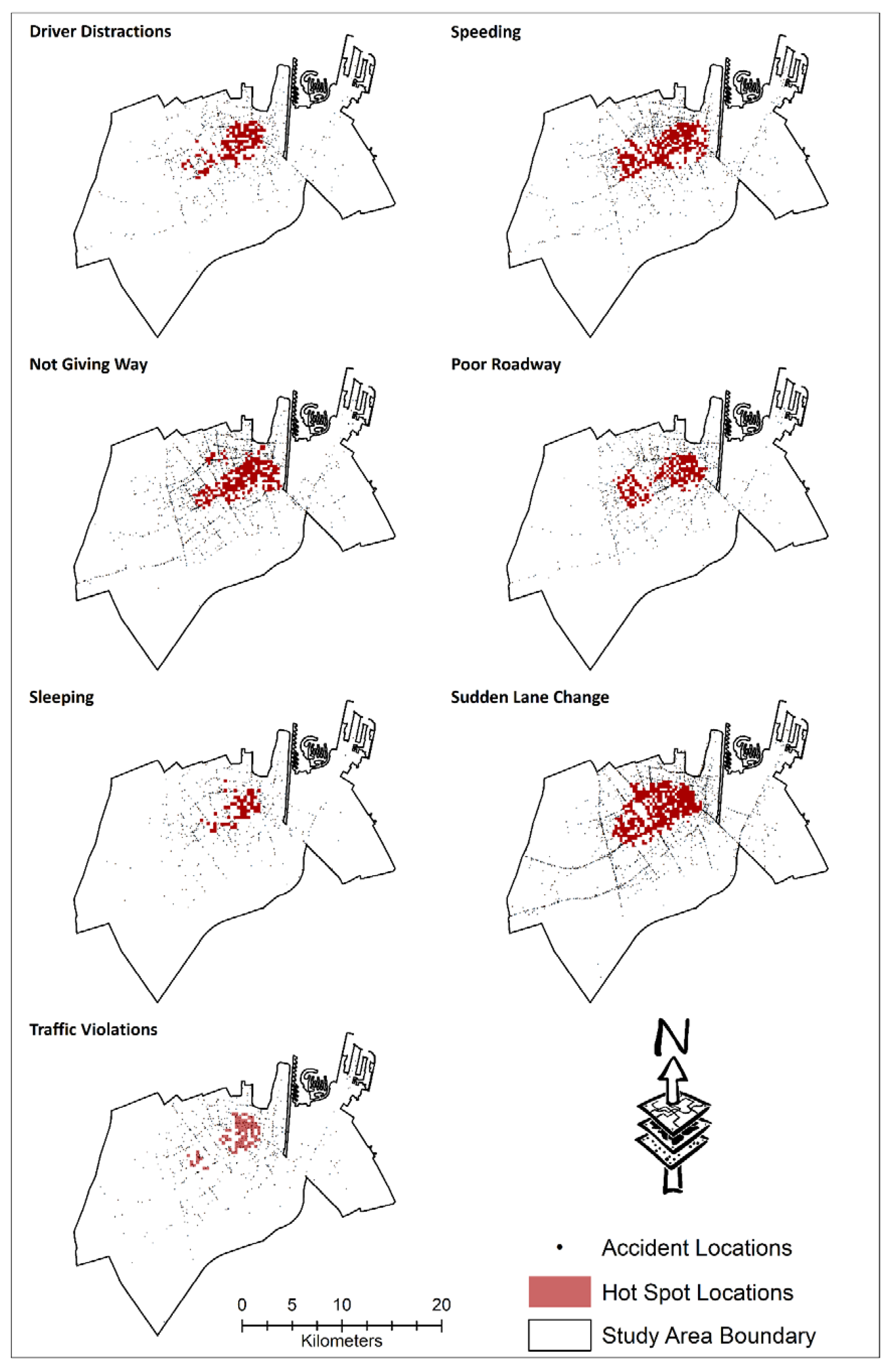
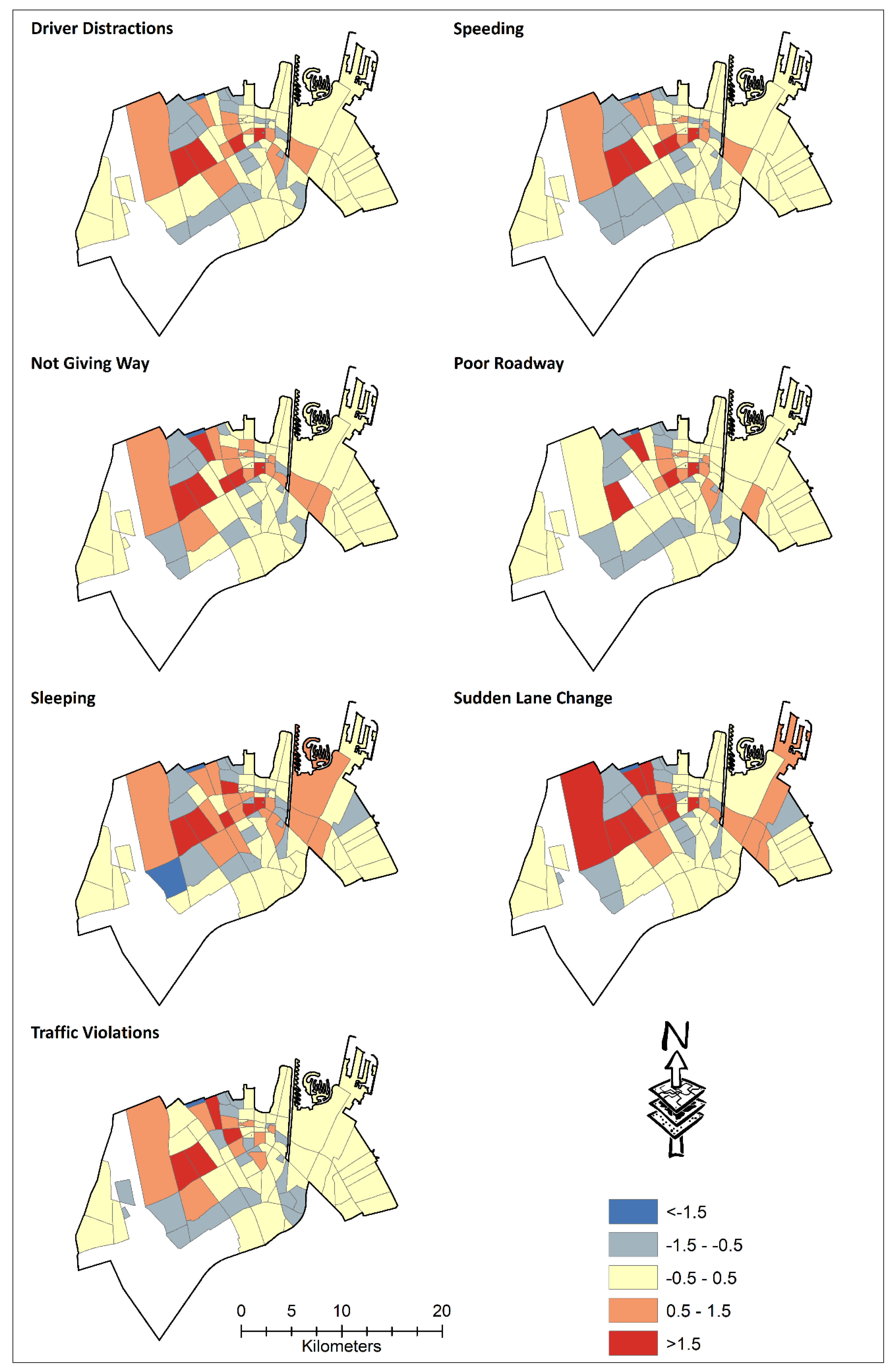
4.2.2. Hotspot Analysis by Crash Causes
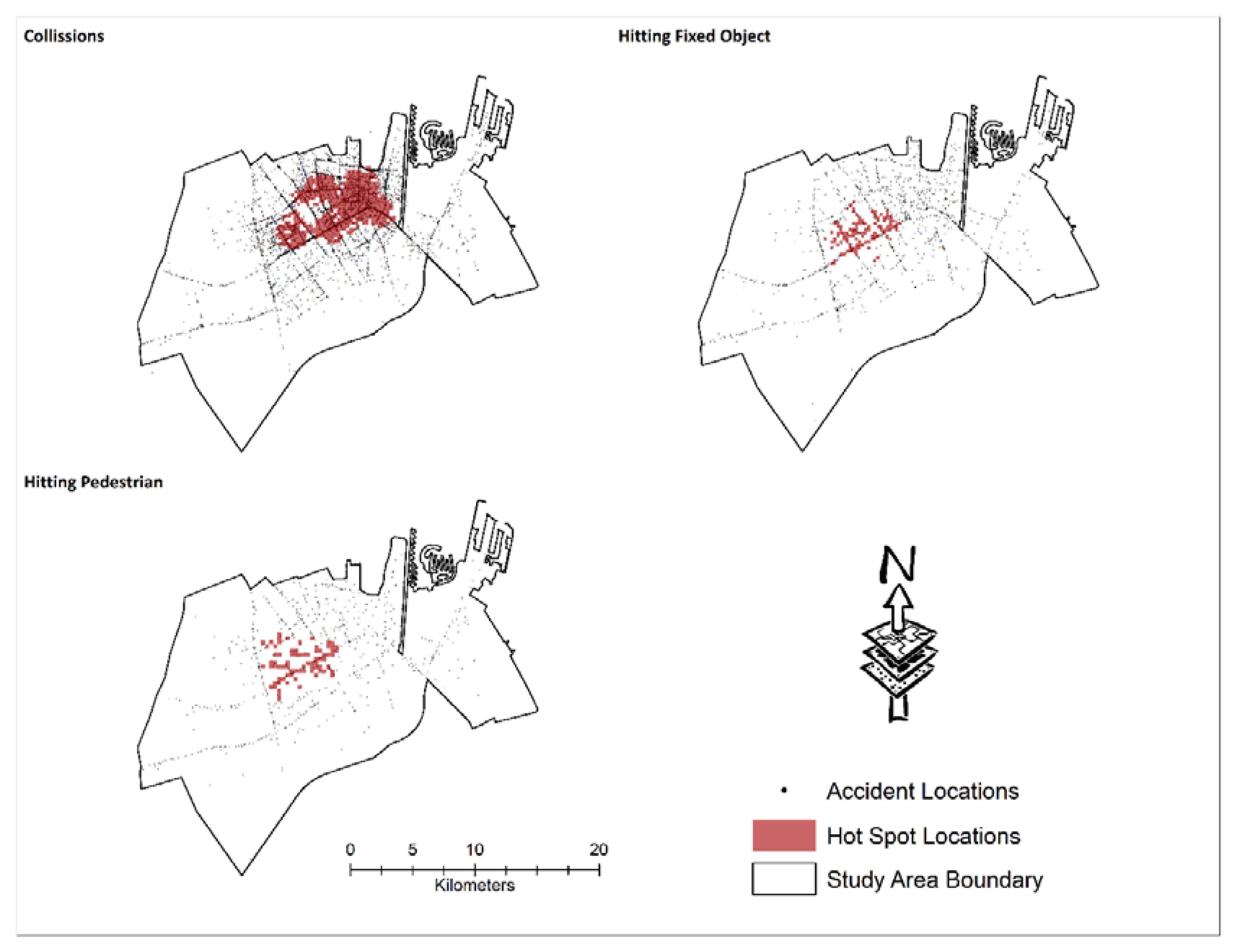
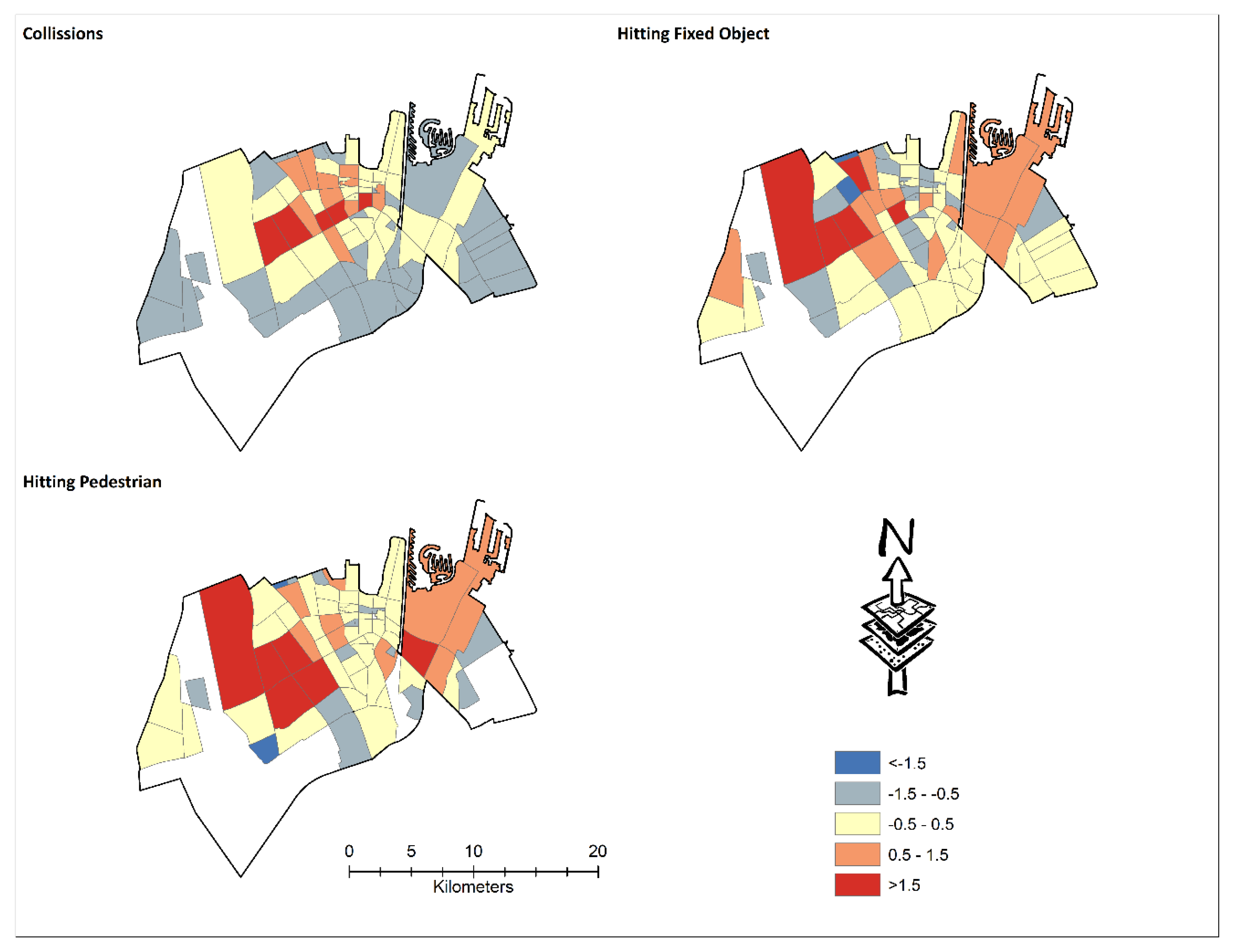
4.2.3. Hotspot Analysis by Crash Types
4.3. GWR Analysis for Land Use Neighborhood Population and Crash Counts Severity, Causes, and Types
4.3.1. GWR Analysis for Neighborhood Crash Severity
4.3.2. GWR Analysis for Neighborhood Crash Causes
4.3.3. GWR Analysis for Neighborhood Crash Types
5. Conclusions
Author Contributions
Funding
Acknowledgments
Conflicts of Interest
References
- World Health Organization. Global Status Report on Road Safety 2018; WHO: Geneva, Switzerland, 2019. [Google Scholar]
- Janstrup, K.H. Road Safety Annual Report; OECD Publishing: Paris, France, 2017. [Google Scholar] [CrossRef] [Green Version]
- Al Turki, Y.A. How can Saudi Arabia use the Decade of Action for Road Safety to catalyse road traffic injury prevention policy and interventions? Int. J. Inj. Control. Saf. Promot. 2013, 21, 397–402. [Google Scholar] [CrossRef] [PubMed]
- Mohamed, H.A. Estimation of socio-economic cost of road accidents in Saudi Arabia: Willingness-to-pay approach (WTP). Adv. Manag. Appl. Econom. 2015, 5, 43. [Google Scholar]
- Jamal, A.; Rahman, M.T.; Al-Ahmadi, H.M.; Mansoor, U. The Dilemma of Road Safety in the Eastern Province of Saudi Arabia: Consequences and Prevention Strategies. Int. J. Environ. Res. Public Health 2019, 17, 157. [Google Scholar] [CrossRef] [PubMed] [Green Version]
- Gundogdu, I.B. Applying linear analysis methods to GIS-supported procedures for preventing traffic accidents: Case study of Konya. Saf. Sci. 2010, 48, 763–769. [Google Scholar] [CrossRef]
- Lord, D.; Washington, S.; Ivan, J. Poisson, Poisson-gamma and zero-inflated regression models of motor vehicle crashes: Balancing statistical fit and theory. Accid. Anal. Prev. 2005, 37, 35–46. [Google Scholar] [CrossRef]
- Lord, D.; Mannering, F.L. The statistical analysis of crash-frequency data: A review and assessment of methodological alternatives. Transp. Res. Part A Policy Pract. 2010, 44, 291–305. [Google Scholar] [CrossRef] [Green Version]
- Abdulhafedh, A. Road Crash Prediction Models: Different Statistical Modeling Approaches. J. Transp. Technol. 2017, 7, 190–205. [Google Scholar] [CrossRef]
- Maher, M.J.; Summersgill, I. A comprehensive methodology for the fitting of predictive accident models. Accid. Anal. Prev. 1996, 28, 281–296. [Google Scholar] [CrossRef]
- Miaou, S.-P.; Lum, H. Modeling vehicle accidents and highway geometric design relationships. Accid. Anal. Prev. 1993, 25, 689–709. [Google Scholar] [CrossRef]
- Milton, J.; Mannering, F.L. The relationship among highway geometrics, traffic-related elements and motor-vehicle accident frequencies. Transportation 1998, 25, 395–413. [Google Scholar] [CrossRef]
- Abdel-Aty, M.; Uddin, N.; Pande, A. Split models for predicting multivehicle crashes during high-speed and low-speed operating conditions on freeways. Transp. Res. Rec. 2005, 1908, 51–58. [Google Scholar] [CrossRef]
- Lee, C.; Hellinga, B.; Saccomanno, F. Real-Time Crash Prediction Model for Application to Crash Prevention in Freeway Traffic. Transp. Res. Rec. 2003, 1840, 67–77. [Google Scholar] [CrossRef]
- Montella, A. A comparative analysis of hotspot identification methods. Accid. Anal. Prev. 2010, 42, 571–581. [Google Scholar] [CrossRef] [PubMed]
- Qu, X.; Meng, Q. A note on hotspot identification for urban expressways. Saf. Sci. 2014, 66, 87–91. [Google Scholar] [CrossRef] [Green Version]
- Huang, H.; Chin, H.C.; Haque, M. Empirical Evaluation of Alternative Approaches in Identifying Crash Hot Spots. Transp. Res. Rec. 2009, 2103, 32–41. [Google Scholar] [CrossRef]
- Yu, H.; Liu, Z.-H.; Chen, J.; Wang, H. Comparative analysis of the spatial analysis methods for hotspot identification. Accid. Anal. Prev. 2014, 66, 80–88. [Google Scholar] [CrossRef]
- Debrabant, B.; Halekoh, U.; Bonat, W.H.; Hansen, D.L.; Hjelmborg, J.B.; Lauritsen, J.M. Identifying traffic accident black spots with Poisson-Tweedie models. Accid. Anal. Prev. 2018, 111, 147–154. [Google Scholar] [CrossRef] [PubMed]
- Dong, N.; Huang, H.; Lee, J.; Gao, M.; Abdel-Aty, M. Macroscopic hotspots identification: A Bayesian spatio-temporal interaction approach. Accid. Anal. Prev. 2016, 92, 256–264. [Google Scholar] [CrossRef] [PubMed]
- Ghadi, M.; Török, Á. Comparison Different Black Spot Identification Methods. Transp. Res. Procedia 2017, 27, 1105–1112. [Google Scholar] [CrossRef]
- Anderson, T.K. Kernel density estimation and K-means clustering to profile road accident hotspots. Accid. Anal. Prev. 2009, 41, 359–364. [Google Scholar] [CrossRef]
- Xie, Z.; Yan, J. Detecting traffic accident clusters with network kernel density estimation and local spatial statistics: An integrated approach. J. Transp. Geogr. 2013, 31, 64–71. [Google Scholar] [CrossRef]
- Moons, E.; Brijs, T.; Wets, G. Identifying Hazardous Road Locations: Hot Spots versus Hot Zones. In Computer Vision; Springer Science and Business Media LLC: Berlin, Germany, 2009; Volume 5730, pp. 288–300. [Google Scholar]
- Shariff, S.R.; Maad, H.A.; Halim, N.N.A.; Derasit, Z. Determining Hotspots of Road Accidents using Spatial Analysis. Indones. J. Electr. Eng. Comput. Sci. 2018, 9, 146–151. [Google Scholar] [CrossRef]
- Thakali, L.; Kwon, T.J.; Fu, L. Identification of crash hotspots using kernel density estimation and kriging methods: A comparison. J. Mod. Transp. 2015, 23, 93–106. [Google Scholar] [CrossRef] [Green Version]
- Soltani, A.; Askari, S. Exploring spatial autocorrelation of traffic crashes based on severity. Injury 2017, 48, 637–647. [Google Scholar] [CrossRef] [PubMed]
- Erdogan, S.; Yilmaz, I.; Baybura, T.; Gullu, M.; Yılmaz, I. Geographical information systems aided traffic accident analysis system case study: City of Afyonkarahisar. Accid. Anal. Prev. 2008, 40, 174–181. [Google Scholar] [CrossRef] [PubMed]
- Chen, C.; Li, T.; Sun, J.; Chen, F. Hotspot Identification for Shanghai Expressways Using the Quantitative Risk Assessment Method. Int. J. Environ. Res. Public Health 2016, 14, 20. [Google Scholar] [CrossRef] [PubMed]
- Cheng, W.; Washington, S. Experimental evaluation of hotspot identification methods. Accid. Anal. Prev. 2005, 37, 870–881. [Google Scholar] [CrossRef]
- Zou, Y.; Zhong, X.; Ash, J.; Zeng, Z.; Wang, Y.; Hao, Y.; Peng, Y. Developing a Clustering-Based Empirical Bayes Analysis Method for Hotspot Identification. J. Adv. Transp. 2017, 2017, 1–9. [Google Scholar] [CrossRef]
- Lan, B.; Persaud, B. Fully Bayesian Approach to Investigate and Evaluate Ranking Criteria for Black Spot Identification. Transp. Res. Rec. 2011, 2237, 117–125. [Google Scholar] [CrossRef]
- Kim, K.; Yamashita, E. Motor Vehicle Crashes and Land Use: Empirical Analysis from Hawaii. Transp. Res. Rec. 2002, 1784, 73–79. [Google Scholar] [CrossRef]
- Zahid, M.; Chen, Y.; Khan, S.; Jamal, A.; Ijaz, M.; Ahmed, T. Predicting Risky and Aggressive Driving Behavior among Taxi Drivers: Do Spatio-Temporal Attributes Matter? Int. J. Environ. Res. Public Health 2020, 17, 3937. [Google Scholar] [CrossRef]
- Jamal, A.; Rahman, M.T.; Al-Ahmadi, H.M.; Ullah, H.M.; Zahid, M. Intelligent Intersection Control for Delay Optimization: Using Meta-Heuristic Search Algorithms. Sustainability 2020, 12, 1896. [Google Scholar] [CrossRef] [Green Version]
- Elias, W.; Shiftan, Y. The influence of individual’s risk perception and attitudes on travel behavior. Transp. Res. Part A Policy Pract. 2012, 46, 1241–1251. [Google Scholar] [CrossRef]
- Zahid, M.; Chen, Y.; Jamal, A.; Al-Ofi, K.A.; Al-Ahmadi, H.M. Adopting Machine Learning and Spatial Analysis Techniques for Driver Risk Assessment: Insights from a Case Study. Int. J. Environ. Res. Public Health 2020, 17, 5193. [Google Scholar] [CrossRef]
- Kundakci, E.; Tuydes-Yaman, H. Understanding the Distribution of Traffic Accident Hot Spots in Urban Regions. In Proceedings of the Transportation Research Board 93rd Annual Meeting, Washington, DC, USA, 12–16 January 2014. [Google Scholar]
- Ben-Hamouche, M.; Al-janahi, A.; Al-Madani, H. Traffic accidents in Bahrain: A statistical and spatial GIS-based analysis. J. King Saud Univ. 2011, 23, 1–18. [Google Scholar]
- Noland, R.B.; Quddus, M. A spatially disaggregate analysis of road casualties in England. Accid. Anal. Prev. 2004, 36, 973–984. [Google Scholar] [CrossRef] [PubMed] [Green Version]
- Xie, B.; An, Z.; Zheng, Y.; Li, Z. Incorporating transportation safety into land use planning: Pre-assessment of land use conversion effects on severe crashes in urban China. Appl. Geogr. 2019, 103, 1–11. [Google Scholar] [CrossRef]
- Pulugurtha, S.S.; Duddu, V.R.; Kotagiri, Y. Traffic analysis zone level crash estimation models based on land use characteristics. Accid. Anal. Prev. 2013, 50, 678–687. [Google Scholar] [CrossRef]
- Yang, B.Z.; Loo, B.P.; Yang, Z. Land use and traffic collisions: A link-attribute analysis using Empirical Bayes method. Accid. Anal. Prev. 2016, 95, 236–249. [Google Scholar] [CrossRef]
- Chen, P.; Zhou, J. Effects of the built environment on automobile-involved pedestrian crash frequency and risk. J. Transp. Health 2016, 3, 448–456. [Google Scholar] [CrossRef] [Green Version]
- Shafabakhsh, G.A.; Famili, A.; Bahadori, M.S. GIS-based spatial analysis of urban traffic accidents: Case study in Mashhad, Iran. J. Traffic Transp. Eng. 2017, 4, 290–299. [Google Scholar] [CrossRef]
- Mohaymany, A.S.; Shahri, M.; Mirbagheri, B. GIS-based method for detecting high-crash-risk road segments using network kernel density estimation. Geo-Spat. Inf. Sci. 2013, 16, 113–119. [Google Scholar] [CrossRef]
- Ulak, M.B.; Ozguven, E.E.; Vanli, O.A.; Horner, M.W. Exploring alternative spatial weights to detect crash hotspots. Comput. Environ. Urban Syst. 2019, 78, 101398. [Google Scholar] [CrossRef]
- Bíl, M.; Andrášik, R.; Sedoník, J. A detailed spatiotemporal analysis of traffic crash hotspots. Appl. Geogr. 2019, 107, 82–90. [Google Scholar] [CrossRef]
- Dereli, M.A.; Erdogan, S. A new model for determining the traffic accident black spots using GIS-aided spatial statistical methods. Transp. Res. Part A Policy Pract. 2017, 103, 106–117. [Google Scholar] [CrossRef]
- Yalcin, G.; Duzgun, H.S. Spatial analysis of two-wheeled vehicles traffic crashes: Osmaniye in Turkey. KSCE J. Civ. Eng. 2015, 19, 2225–2232. [Google Scholar] [CrossRef]
- Yuan, T.; Zeng, X.; Shi, T. Identifying Urban Road Black Spots with a Novel Method Based on the Firefly Clustering Algorithm and a Geographic Information System. Sustainability 2020, 12, 2091. [Google Scholar] [CrossRef] [Green Version]
- Butt, A.; Ahmad, S.S.; Shabbir, R.; Erum, S. GIS based surveillance of road traffic accidents (rta) risk for Rawalpindi city: A geo-statistical approach. Kuwait J. Sci. 2017, 44, 129–134. [Google Scholar]
- Le, K.G.; Liu, P.; Lin, L.-T. Determining the road traffic accident hotspots using GIS-based temporal-spatial statistical analytic techniques in Hanoi, Vietnam. Geo-Spat. Inf. Sci. 2019, 1–12. [Google Scholar] [CrossRef] [Green Version]
- Zheng, L.; Robinson, R.M.; Khattak, A.; Wang, X. All accidents are not equal: Using geographically weighted regressions models to assess and forecast accident impacts. In Proceedings of the 3rd International Conference on Road Safety and Simulation, Indianapolis, IN, USA, 14–16 September 2011; pp. 14–16. [Google Scholar]
- Soroori, E.; Moghaddam, A.M.; Salehi, M. Modeling spatial nonstationary and overdispersed crash data: Development and comparative analysis of global and geographically weighted regression models applied to macrolevel injury crash data. J. Transp. Saf. Secur. 2020, 1–25. [Google Scholar] [CrossRef]
- Li, Z.; Wang, W.; Liu, Z.-H.; Bigham, J.M.; Ragland, D.R. Using Geographically Weighted Poisson Regression for county-level crash modeling in California. Saf. Sci. 2013, 58, 89–97. [Google Scholar] [CrossRef]
- Li, Z.; Lee, Y.; Lee, S.H.; Valiou, E. Geographically-Weighted Regression Models for Improved Predictability of Urban Intersection Vehicle Crashes. In Proceedings of the Transportation and Development Institute Congress 2011: Integrated Transportation and Development for a Better Tomorrow, Chicago, IL, USA, 13–16 March 2011; pp. 1315–1329. [Google Scholar]
- Pirdavani, A.; Brijs, T.; Bellemans, T.; Wets, G. Spatial analysis of fatal and injury crashes in Flanders, Belgium: Application of geographically weighted regression technique. In Proceedings of the 92th Annual Meeting of Transportation Research Board, Washington, DC, USA, 13–17 January 2013. [Google Scholar]
- Li, L.; Zhu, L.; Sui, D.Z. A GIS-based Bayesian approach for analyzing spatial–temporal patterns of intra-city motor vehicle crashes. J. Transp. Geogr. 2007, 15, 274–285. [Google Scholar] [CrossRef]
- Huang, Y.; Wang, X.; Patton, D. Examining spatial relationships between crashes and the built environment: A geographically weighted regression approach. J. Transp. Geogr. 2018, 69, 221–233. [Google Scholar] [CrossRef]
- Ye, Y.; Zuo, Z.; Yuan, X.; Zhang, S.; Zeng, X.; An, Y.; Chen, B. Geographically weighted regression model for urban traffic black-spot analysis. In Proceedings of the 2017 IEEE International Geoscience and Remote Sensing Symposium (IGARSS), Forth Worth, TX, USA, 23–28 July 2017; pp. 4866–4869. [Google Scholar]
- Rahman, M.T.; Aldosary, A.S.; Mortoja, G. Modeling Future Land Cover Changes and Their Effects on the Land Surface Temperatures in the Saudi Arabian Eastern Coastal City of Dammam. Land 2017, 6, 36. [Google Scholar] [CrossRef]
- General Authority for Statistics Population Statistics Kingdom of Saudi Arabia: Population Statistics by Areas. Available online: https://www.stats.gov.sa/en/43 (accessed on 15 July 2020).
- Traffic General Directorate. Number of Registered Vehicles in the Kingdom by Region; General Authority for Statistics: Riyadh, Saudi Arabia, 2018.
- Rahman, M.T.; Nahiduzzaman, K.M. Examining the Walking Accessibility, Willingness, and Travel Conditions of Residents in Saudi Cities. Int. J. Environ. Res. Public Health 2019, 16, 545. [Google Scholar] [CrossRef] [Green Version]
- Iyanda, A.E.; Osayomi, T. Is there a relationship between economic indicators and road fatalities in Texas? A multiscale geographically weighted regression analysis. GeoJournal 2020. [Google Scholar] [CrossRef]
- Ratrout, N. Tire condition and drivers’ practice in maintaining tires in Saudi Arabia. Accid. Anal. Prev. 2005, 37, 201–206. [Google Scholar] [CrossRef]
- Gazzete, S. Tire Blowouts Cause 30 Percent of Accidents on Saudi Roads: 2013. Available online: https://saudigazette.com.sa/article/58576 (accessed on 3 September 2020).
- Lee, M.; Khattak, A.J. Case Study of Crash Severity Spatial Pattern Identification in Hot Spot Analysis. Transp. Res. Rec. J. Transp. Res. Board 2019, 2673, 684–695. [Google Scholar] [CrossRef]
- Dai, D.; Jaworski, D. Influence of built environment on pedestrian crashes: A network-based GIS analysis. Appl. Geogr. 2016, 73, 53–61. [Google Scholar] [CrossRef]


| Variables | No. of Incidences | Observed Mean Distance (m) | Mean/Expected Random Distance (m) | NNI | Z-Value | # of Incidences Within Hotspot Zones | % of Incidences Within the Hotspot Zones |
|---|---|---|---|---|---|---|---|
| Crash Severity | |||||||
| FI | 2706 | 102.9 | 203.95 | 0.50 | −50.32 | 841 | 31.1 |
| PDO | 8833 | 48.52 | 112.85 | 0.43 | −102.48 | 4700 | 53.2 |
| Crash Types | |||||||
| Collisions | 7902 | 48.72 | 119.31 | 0.41 | −100.60 | 4210 | 53.3 |
| Fixed object | 1479 | 141.65 | 275.77 | 0.51 | −35.78 | 254 | 17.2 |
| Hit pedestrians | 900 | 206.29 | 353.71 | 0.58 | −23.91 | 174 | 19.3 |
| Crash Causes | |||||||
| Driver distraction | 966 | 182.20 | 345.54 | 0.53 | −27.76 | 293 | 30.3 |
| Sudden lane change | 3211 | 82.52 | 187.22 | 0.44 | −60.60 | 1410 | 43.9 |
| Not giving way | 2529 | 99.39 | 212.83 | 0.47 | −58.84 | 962 | 38.0 |
| Speeding | 1920 | 118.13 | 243.63 | 0.49 | −42.90 | 890 | 46.4 |
| Sleeping | 657 | 217.40 | 415.98 | 0.52 | −23.29 | 131 | 19.9 |
| Poor roadway | 1430 | 141.78 | 282.64 | 0.50 | −35.77 | 531 | 37.1 |
| Traffic violations | 786 | 212.58 | 375.90 | 0.56 | −23.45 | 224 | 28.5 |
© 2020 by the authors. Licensee MDPI, Basel, Switzerland. This article is an open access article distributed under the terms and conditions of the Creative Commons Attribution (CC BY) license (http://creativecommons.org/licenses/by/4.0/).
Share and Cite
Rahman, M.T.; Jamal, A.; Al-Ahmadi, H.M. Examining Hotspots of Traffic Collisions and their Spatial Relationships with Land Use: A GIS-Based Geographically Weighted Regression Approach for Dammam, Saudi Arabia. ISPRS Int. J. Geo-Inf. 2020, 9, 540. https://0-doi-org.brum.beds.ac.uk/10.3390/ijgi9090540
Rahman MT, Jamal A, Al-Ahmadi HM. Examining Hotspots of Traffic Collisions and their Spatial Relationships with Land Use: A GIS-Based Geographically Weighted Regression Approach for Dammam, Saudi Arabia. ISPRS International Journal of Geo-Information. 2020; 9(9):540. https://0-doi-org.brum.beds.ac.uk/10.3390/ijgi9090540
Chicago/Turabian StyleRahman, Muhammad Tauhidur, Arshad Jamal, and Hassan M. Al-Ahmadi. 2020. "Examining Hotspots of Traffic Collisions and their Spatial Relationships with Land Use: A GIS-Based Geographically Weighted Regression Approach for Dammam, Saudi Arabia" ISPRS International Journal of Geo-Information 9, no. 9: 540. https://0-doi-org.brum.beds.ac.uk/10.3390/ijgi9090540