Next Issue
Volume 10, November
Previous Issue
Volume 10, September


Atmosphere, Volume 10, Issue 10 (October 2019) – 76 articles

Cover Story (view full-size image): 
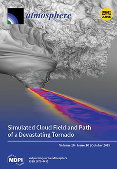
On 24 May 2011, a devastating EF5 tornado carved a path of destruction through El Reno, Oklahoma. Using the environment preceding the real event as initial conditions, the formation of a powerful tornado within a supercell thunderstorm was simulated on a Blue Waters supercomputer. The simulated tornado exhibited winds exceeding 500 km/h and pressure drops of more than 200 hPa. VAPOR visualization software was used to produce the image in which the cloud field and surface pressure trace are shown. Cycloidal patterns in the surface pressure field (in dark blue) resemble the damage swaths often observed following the passage of some of the strongest tornadoes. These patterns are caused by the powerful winds of individual suction vortices that comprise the multiple-vortex tornado. View this paper.
  • Issues are regarded as officially published after their release is announced to the table of contents alert mailing list.
  • You may sign up for e-mail alerts to receive table of contents of newly released issues.
  • PDF is the official format for papers published in both, html and pdf forms. To view the papers in pdf format, click on the "PDF Full-text" link, and use the free Adobe Reader to open them.
Order results
Result details
Section
Select all
Export citation of selected articles as:
16 pages, 3864 KiB  
Article
Optical and Physical Characteristics of the Lowest Aerosol Layers over the Yellow River Basin
by Miao Zhang, Jing Liu, Muhammad Bilal, Chun Zhang, Feifei Zhao, Xiaoyan Xie and Khaled Mohamed Khedher
Atmosphere 2019, 10(10), 638; https://0-doi-org.brum.beds.ac.uk/10.3390/atmos10100638 - 22 Oct 2019
Cited by 7 | Viewed by 2489
Abstract
Studying the presence of aerosols in different atmospheric layers helps researchers understand their impacts on climate change, air quality, and human health. Therefore, in the present study, the optical and physical properties of aerosol layers over the Yellow River Basin (YERB) were investigated [...] Read more.
Studying the presence of aerosols in different atmospheric layers helps researchers understand their impacts on climate change, air quality, and human health. Therefore, in the present study, the optical and physical properties of aerosol layers over the Yellow River Basin (YERB) were investigated using the CALIPSO Level 2 aerosol layer products from January 2007 to December 2014. The Yellow River Basin was divided into three sub-regions i.e., YERB1 (the plain region downstream of the YERB), YERB2 (the Loess Plateau region in the middle reaches of the YERB), and YERB3 (the mountainous terrain in the upper reaches of the YERB). The results showed that the amount (number) of aerosol layers (N) was relatively large (>2 layers) in the lower part of the YERB (YERB1), which was mainly caused by atmospheric convection. The height of the highest aerosol layer top (HTH) and the height of the lowest aerosol layers base (HB1) varied significantly with respect to the topography of the YERB. High and low values of aerosol optical depth (AOD) were observed over the YERB1 (plain area) and YERB3 (elevated area) regions, respectively. Population, economy, and agricultural activities might be the possible reasons for spatial variations in AOD. AOD values for the lowest aerosol layer were high—between 0.7 and 1.0 throughout the year—indicating that aerosols were mainly concentrated at the bottom layer of the atmosphere. In addition, the integrated volume depolarization ratio (0.15–0.2) and the integrated attenuated total color ratio (~0.1) were large during spring for the lowest aerosol layer due to the presence of dust aerosols. The thicknesses of the lowest aerosol layers (TL1) did not vary with respect to the topographic features of the YERB. Over the sub-regions of the YERB, a significant positive correlation between the AOD of the lowest aerosol layer (AOD1) and the thickness of the lowest aerosol layer (TL1) was found, which indicates that TL1 increases with the increase of AOD1. In the whole YERB, a positive linear correlation between the N and HTH was observed, whereas a negative correlation between N and the portion of AOD for the lowest aerosol layer (PAOD1) was found, which revealed that the large value of N leads to the small value of PAOD1. The results from the present study will be helpful to further investigate the aerosol behavior and their impacts on climate change, air quality, and human health over the YERB. Full article
(This article belongs to the Section Aerosols)
Show Figures

Figure 1

12 pages, 2409 KiB  
Article
Airglow Derived Measurements of Q-Branch Transition Probabilities for Several Hydroxyl Meinel Bands
by Christoph Franzen, Patrick Joseph Espy, Niklas Hofmann, Robert Edward Hibbins and Anlaug Amanda Djupvik
Atmosphere 2019, 10(10), 637; https://0-doi-org.brum.beds.ac.uk/10.3390/atmos10100637 - 22 Oct 2019
Cited by 4 | Viewed by 3027
Abstract
Spectroscopic measurements of the hydroxyl (OH) airglow emissions are often used to infer neutral temperatures near the mesopause. Correct Einstein coefficients for the various transitions in the OH airglow are needed to calculate accurate temperatures. However, studies showed experimentally and theoretically that the [...] Read more.
Spectroscopic measurements of the hydroxyl (OH) airglow emissions are often used to infer neutral temperatures near the mesopause. Correct Einstein coefficients for the various transitions in the OH airglow are needed to calculate accurate temperatures. However, studies showed experimentally and theoretically that the most commonly used Einstein spontaneous emission transition probabilities for the Q-branch of the OH Meinel (6,2) transition are overestimated. Extending their work to several Δv = 2 and 3 transitions from v′ = 3 to 9, we have determined Einstein coefficients for the first four Q-branch rotational lines. These have been derived from high resolution, high signal to noise spectroscopic observations of the OH airglow in the night sky from the Nordic Optical Telescope. The Q-branch Einstein coefficients calculated from these spectra show that values currently tabulated in the HITRAN database overestimate many of the Q-branch transition probabilities. The implications for atmospheric temperatures derived from OH Q-branch measurements are discussed. Full article
Show Figures

Figure 1

23 pages, 5278 KiB  
Article
Spatial-Temporal Variability of Land Surface Dry Anomalies in Climatic Aspect: Biogeophysical Insight by Meteosat Observations and SVAT Modeling
by Julia Stoyanova, Christo Georgiev, Plamen Neytchev and Andrey Kulishev
Atmosphere 2019, 10(10), 636; https://0-doi-org.brum.beds.ac.uk/10.3390/atmos10100636 - 22 Oct 2019
Cited by 10 | Viewed by 3174
Abstract
The spatial-temporal variability of drought occurrence over Bulgaria is characterized based on long-term records (2007–2018) of Meteosat information and the SVAT model-derived soil moisture availability index (referred to root zone depth, SMAI). Land surface temperature according to the satellite-derived Land Surface Analysis Satellite [...] Read more.
The spatial-temporal variability of drought occurrence over Bulgaria is characterized based on long-term records (2007–2018) of Meteosat information and the SVAT model-derived soil moisture availability index (referred to root zone depth, SMAI). Land surface temperature according to the satellite-derived Land Surface Analysis Satellite Application Facility Land Surface Temperature (LSASAF LST) product and SMAI were used to designate land surface state dry anomalies. The utility of LST for drought assessment is tested by statistical comparative analyses, applying two approaches, site-scale quantitative comparison, and evaluation of spatial-temporal consistency between SMAI and LST variability. Pearson correlation and regression modeling techniques were applied. The main results indicate for a synchronized behavior between SMAI and LST during dry spells, as follows: opposite mean seasonal course (March–October); high to strong negative monthly correlation for different microclimate regimes. Negative linear regressions between the anomalies of SMAI and LST (monthly mean), with a strong correlation in their spatial-temporal variability. Qualitative evaluation of spatial-temporal variability dynamics is analyzed using color maps. Drought-prone areas were identified on the bases of LST maps (monthly mean), and it is illustrated they are more vulnerable to vegetation burning as detected by the Meteosat FRP-PIXEL product. The current study provides an advanced framework for using LST retrievals based on IR satellite observations from the geostationary MSG satellite as an alternative tool to SMAI, whose calculation requires the input of many parameters that are not always available. Full article
Show Figures

Figure 1

1 pages, 136 KiB  
Correction
Correction: Cizdziel, J., et al. Air/Surface Exchange of Gaseous Elemental Mercury at Different Landscapes in Mississippi, USA. Atmosphere 2019, 10, 538
by James V. Cizdziel, Yi Jiang, Divya Nallamothu, J. Stephen Brewer and Zhiqiang Gao
Atmosphere 2019, 10(10), 635; https://0-doi-org.brum.beds.ac.uk/10.3390/atmos10100635 - 22 Oct 2019
Viewed by 1673
Abstract
The authors wish to make the following correction to this paper [...] Full article
(This article belongs to the Special Issue Atmospheric Mercury: Sources, Sinks, and Transformations)
11 pages, 1164 KiB  
Article
The Incidence of Skin Cancer in Relation to Climate Change in South Africa
by Caradee Y. Wright, Mary Norval, Thandi Kapwata, David Jean du Preez, Bianca Wernecke, Bianca M. Tod and Willem I. Visser
Atmosphere 2019, 10(10), 634; https://0-doi-org.brum.beds.ac.uk/10.3390/atmos10100634 - 22 Oct 2019
Cited by 15 | Viewed by 6146
Abstract
Climate change is associated with shifts in global weather patterns, especially an increase in ambient temperature, and is deemed a formidable threat to human health. Skin cancer, a non-communicable disease, has been underexplored in relation to a changing climate. Exposure to solar ultraviolet [...] Read more.
Climate change is associated with shifts in global weather patterns, especially an increase in ambient temperature, and is deemed a formidable threat to human health. Skin cancer, a non-communicable disease, has been underexplored in relation to a changing climate. Exposure to solar ultraviolet radiation (UVR) is the major environmental risk factor for skin cancer. South Africa is situated in the mid-latitudes and experiences relatively high levels of sun exposure with summertime UV Index values greater than 10. The incidence of skin cancer in the population group with fair skin is considered high, with cost implications relating to diagnosis and treatment. Here, the relationship between skin cancer and several environmental factors likely to be affected by climate change in South Africa are discussed including airborne pollutants, solar UVR, ambient temperature and rainfall. Recommended strategies for personal sun protection, such as shade, clothing, sunglasses and sunscreen, may change as human behaviour adapts to a warming climate. Further research and data are required to assess any future impact of climate change on the incidence of skin cancer in South Africa. Full article
Show Figures

Figure 1

14 pages, 3407 KiB  
Article
How Much Does Weather Matter? Effects of Rain and Wind on PM Accumulation by Four Species of Australian Native Trees
by Robert Popek, Alison Haynes, Arkadiusz Przybysz and Sharon A. Robinson
Atmosphere 2019, 10(10), 633; https://0-doi-org.brum.beds.ac.uk/10.3390/atmos10100633 - 21 Oct 2019
Cited by 34 | Viewed by 4784
Abstract
As interest in improving urban air quality grows, phytoremediation—amelioration through plants—is an increasingly popular method of targeting particulate matter (PM), one of the most harmful pollutants. Decades of research has proven that plants effectively capture PM from air; however, more information is needed [...] Read more.
As interest in improving urban air quality grows, phytoremediation—amelioration through plants—is an increasingly popular method of targeting particulate matter (PM), one of the most harmful pollutants. Decades of research has proven that plants effectively capture PM from air; however, more information is needed on the dynamics of PM accumulation. Our study evaluated the effects of meteorological conditions on the dynamics of PM deposition, wash off and resuspension using four Australian tree species growing under natural conditions near a busy highway. Accumulation of PM on foliage was analyzed over the short term (daily changes) and over a longer time period (weekly changes). The results obtained were correlated with ambient concentrations of PM2.5 and PM10, rain intensity and wind strength. The highest accumulation of PM was recorded for Eucalyptus ovata (100.2 µg cm−2), which also had the thickest wax layer while the lowest was for Brachychiton acerifolius (77.9 µg cm−2). PM accumulation was highly changeable, with up to 35% different PM loads on the foliage from one day to the next. Importantly these dynamics are hidden in weekly measurements. Changes in PM deposition on the leaves was mostly affected by rain and to a lesser extent by wind, but the extent of the effect was species specific. The large PM fraction (10–100 µm) was the first to be removed from leaves, while the smallest PM fraction (0.2–2.5 µm) was retained for longer. Precipitation affects also PM retained in waxes, which until now were believed to be not affected by rain. This work demonstrates important interactions between PM load and weather, as well as adding to the small inventory of Australian native tree PM accumulation data. Full article
(This article belongs to the Special Issue Air Quality in New South Wales, Australia)
Show Figures

Figure 1

20 pages, 3984 KiB  
Article
A New Geochemical Method for Determining the Sources of Atmospheric Particles: A Case Study from Gannan, Northeast China
by Chenmeng Yang, Guangyi Sun, Chao Zhang, Yupeng Chen, Wen Yang and Lihai Shang
Atmosphere 2019, 10(10), 632; https://0-doi-org.brum.beds.ac.uk/10.3390/atmos10100632 - 20 Oct 2019
Cited by 2 | Viewed by 2972
Abstract
The geochemical characteristics of atmospheric deposition can help trace the origin and assess the impacts of pollutants. Northeast China has always been a region seriously affected by sandstorms. This study aims to explain the potential source of sandstorms in Gannan County, Heilongjiang Provence, [...] Read more.
The geochemical characteristics of atmospheric deposition can help trace the origin and assess the impacts of pollutants. Northeast China has always been a region seriously affected by sandstorms. This study aims to explain the potential source of sandstorms in Gannan County, Heilongjiang Provence, by collecting dust and analyzing geochemistry in one year where there is no significant industrial or anthropogenic pollution. Input fluxes of deposition show that Zn and Mn were more prevalent (36.7 g·hm−2·a−1 and 77.93 g·hm−2·a−1, respectively) than other elements. The geochemical composition of atmospheric deposition samples from 17 collection points in Gannan County were determined with regard to 20 elements including nine heavy metals, two metalloids, three nonmetallic elements, a transition metal, and five other major elements. The discriminate function (DF) and chemical index of alteration (CIA) indices indicate that Gannan County (agricultural production area) and Harbin (densely inhabited district) have similar geochemical characteristics of dry deposition. The integration of Na/Al and Ca/Mg ratios with an air mass back-trajectories model shows effects from Russian dust sources (36.6%) and from the northwest desert of China (13.3%). The results will assist in developing strategies for reducing dry deposition pollution inputs to agricultural soils in the area and will effectively target policies to protect soils from long-term contaminant accumulation. Full article
(This article belongs to the Special Issue Emissions, Transport and Fate of Pollutants in the Atmosphere)
Show Figures

Figure 1

22 pages, 5435 KiB  
Article
Optimal Band Analysis of a Space-Based Multispectral Sensor for Urban Air Pollutant Detection
by Xiaoyu He, Xiaojian Xu and Zheng Zheng
Atmosphere 2019, 10(10), 631; https://0-doi-org.brum.beds.ac.uk/10.3390/atmos10100631 - 19 Oct 2019
Cited by 5 | Viewed by 2622
Abstract
Air pollution continues to attract more and more public attention. Space-based infrared sensors provide a measure to monitor air quality in large areas. In this paper, a band selection procedure of space-based infrared sensors is proposed for urban air pollutant detection, in which [...] Read more.
Air pollution continues to attract more and more public attention. Space-based infrared sensors provide a measure to monitor air quality in large areas. In this paper, a band selection procedure of space-based infrared sensors is proposed for urban air pollutant detection, in which observation geometry, ground and atmosphere radiant characteristics, and sensor system noise are integrated. The physics-based atmospheric radiative transfer model is reviewed and used to calculate total spectral radiance at the sensor aperture. Spectral filters with different central wavelength and bandwidth are designed to calculate contrasts in various bands, which can be presented as a two-dimensional matrix. Minimal available bandwidth and signal-to-noise ratio threshold are set to characterize the impacts of the sensor system. In this way, the band with higher contrast is assumed to have better detection performance. The proposed procedure is implemented to analyze an optimal band for detecting four types of gaseous pollutants and discriminating aerosol particle pollution to demonstrate usefulness. Simulation results show that narrower bands tend to achieve better performance while the optimal band is related to the available minimal bandwidth and pollutant density. In addition, the bands that are near optimal can achieve similar performance. Full article
Show Figures

Figure 1

1 pages, 139 KiB  
Correction
Correction: Jain, S., et al. The Influence of Absolute Mass Loading of Secondary Organic Aerosols on Their Phase State. Atmosphere, 2018, 9, 131
by Shashank Jain, Kevin B. Fischer and Giuseppe A. Petrucci
Atmosphere 2019, 10(10), 630; https://0-doi-org.brum.beds.ac.uk/10.3390/atmos10100630 - 18 Oct 2019
Viewed by 1880
Abstract
The authors would like to correct the published article [...] Full article
(This article belongs to the Special Issue Formation and Transformation of Organic Aerosol)
13 pages, 614 KiB  
Article
Tsunami-Launched Acoustic Wave in the Layered Atmosphere: Explicit Formulas Including Electron Density Disturbances
by Sergey Leble and Ekaterina Smirnova
Atmosphere 2019, 10(10), 629; https://0-doi-org.brum.beds.ac.uk/10.3390/atmos10100629 - 18 Oct 2019
Cited by 4 | Viewed by 2235
Abstract
The problem of the propagation of acoustic wave disturbance initiated by a boundary condition is used to simulate a disturbance of atmospheric gas caused by a rise of water masses. The boundary condition is a function of a dynamic variable that is defined [...] Read more.
The problem of the propagation of acoustic wave disturbance initiated by a boundary condition is used to simulate a disturbance of atmospheric gas caused by a rise of water masses. The boundary condition is a function of a dynamic variable that is defined on the border of the problem domain. In this work, it is chosen in such a way that its parameters and form correspond to disturbances in the gas layer produced by a tsunami wave at the air–water interface. The atmosphere is approximately described as a 1D multilayer gas media with an exponential structure of density in each layer. The boundary conditions are set at the interface between water–air and gas layers. These determine the direction of propagation and the ratio of dynamic variables characterizing an acoustic wave. The relationship between such variables (pressure, density, and velocity) is derived by means of projection operators on the subspaces of the z-evolution operator for each layer. The universal formulas for the perturbation of atmospheric variables in an arbitrary layer are obtained in frequency and time domains. As a result, explicit expressions are derived that determine the spectral composition and vertical velocity, by the stationary phase method, of the acoustic disturbance of the atmosphere at an arbitrary height, including the heights of the ionosphere. In return, this can be used to calculate the ionospheric effect. The effect is described by the explicit formula for electron density evolution, which is the solution of the diffusion equation. This forms a quick algorithm for early diagnostics of tsunami waves. Full article
(This article belongs to the Special Issue Atmospheric Acoustic-Gravity Waves)
Show Figures

Figure 1

19 pages, 5991 KiB  
Article
Impacts of the Desiccated Lake System on Precipitation in the Basin of Mexico City
by Erika López-Espinoza, Angel Ruiz-Angulo, Jorge Zavala-Hidalgo, Rosario Romero-Centeno and Josefina Escamilla-Salazar
Atmosphere 2019, 10(10), 628; https://0-doi-org.brum.beds.ac.uk/10.3390/atmos10100628 - 17 Oct 2019
Cited by 8 | Viewed by 4117
Abstract
Mexico City constitutes one of the largest concentrations of population on the planet and is settled in a valley that, before the 16th century, had a lake system. The lakes were desiccated artificially, and currently, only small lakes remain. The impact of the [...] Read more.
Mexico City constitutes one of the largest concentrations of population on the planet and is settled in a valley that, before the 16th century, had a lake system. The lakes were desiccated artificially, and currently, only small lakes remain. The impact of the lake system desiccation on precipitation was studied by performing numerical experiments: with the ancient lake system and without it. The experiments were carried out with the Weather Research and Forecasting (WRF) model coupled with a lake model for two months, using identical initial and boundary conditions, where only the system and lake physics were changed. The mean daily accumulated precipitation reduced when the system was removed. Additionally, the hourly distribution of rainfall changed from a relatively small diurnal variability when there was a lake system to a larger variability with a peak in the afternoon when the system was removed. Extreme precipitation events became more intense in the simulations with lakes. When the lakes were removed, the diurnal temperature range increased, and the boundary layer height became more variable, with a higher daily maximum. The results presented here show that the WRF-Lake model leads to opposite results compared to those with a non-coupled lake. Full article
(This article belongs to the Special Issue Weather Research and Forecasting (WRF) Model)
Show Figures

Figure 1

21 pages, 6294 KiB  
Article
Characterization of Moisture Sources for Austral Seas and Relationship with Sea Ice Concentration
by Michelle Simões Reboita, Raquel Nieto, Rosmeri P. da Rocha, Anita Drumond, Marta Vázquez and Luis Gimeno
Atmosphere 2019, 10(10), 627; https://0-doi-org.brum.beds.ac.uk/10.3390/atmos10100627 - 17 Oct 2019
Cited by 3 | Viewed by 3324
Abstract
In this study, the moisture sources acting over each sea (Weddell, King Haakon VII, East Antarctic, Amundsen-Bellingshausen, and Ross-Amundsen) of the Southern Ocean during 1980–2015 are identified with the FLEXPART Lagrangian model and by using two approaches: backward and forward analyses. Backward analysis [...] Read more.
In this study, the moisture sources acting over each sea (Weddell, King Haakon VII, East Antarctic, Amundsen-Bellingshausen, and Ross-Amundsen) of the Southern Ocean during 1980–2015 are identified with the FLEXPART Lagrangian model and by using two approaches: backward and forward analyses. Backward analysis provides the moisture sources (positive values of Evaporation minus Precipitation, E − P > 0), while forward analysis identifies the moisture sinks (E − P < 0). The most important moisture sources for the austral seas come from midlatitude storm tracks, reaching a maximum between austral winter and spring. The maximum in moisture sinks, in general, occurs in austral end-summer/autumn. There is a negative correlation (higher with 2-months lagged) between moisture sink and sea ice concentration (SIC), indicating that an increase in the moisture sink can be associated with the decrease in the SIC. This correlation is investigated by focusing on extremes (high and low) of the moisture sink over the Weddell Sea. Periods of high (low) moisture sinks show changes in the atmospheric circulation with a consequent positive (negative) temperature anomaly contributing to decreasing (increasing) the SIC over the Weddell Sea. This study also suggests possible relationships between the positive (negative) phase of the Southern Annular Mode with the increase (decrease) in the moisture that travels from the midlatitude sources to the Weddell Sea. Full article
(This article belongs to the Special Issue Analysis of Oceanic and Terrestrial Atmospheric Moisture Sources)
Show Figures

Figure 1

18 pages, 2343 KiB  
Review
Review of PM Oxidative Potential Measured with Acellular Assays in Urban and Rural Sites across Italy
by Maria Chiara Pietrogrande, Mara Russo and Elisa Zagatti
Atmosphere 2019, 10(10), 626; https://0-doi-org.brum.beds.ac.uk/10.3390/atmos10100626 - 16 Oct 2019
Cited by 45 | Viewed by 5064
Abstract
This work is an overview of the oxidative potential (OP) values up to date measured in Italy, with the aim to provide a picture of the spatial and seasonal variability of OP in the various geographical areas across Italy. The summarized works used [...] Read more.
This work is an overview of the oxidative potential (OP) values up to date measured in Italy, with the aim to provide a picture of the spatial and seasonal variability of OP in the various geographical areas across Italy. The summarized works used the common acellular assays-based dithiothreitol (OPDTT), ascorbic acid (OPAA), glutathione (OPGSH), and 2′,7′-dichlorodfluorescein (OPDCFH) assays. The paper describes the association of OP responses with PM chemical composition, the sensitivity of various acellular OP assays to PM components and emission sources, and PM size distribution of the measured OP values. Our synthesis indicates that crustal and transition metals (e.g., Fe, Ni, Cu, Cr, Mn, Zn, and V), secondary ions and carbonaceous components (elemental carbon, EC, organic carbon, OC and water soluble carbon, WSOC) show significant correlations with OP across different urban and rural areas and size ranges. These chemical species are mainly associated with various PM sources, including residual/fuel oil combustion, traffic emissions, and secondary organic aerosol formation. Although the OP assays are sensitive to the same redox-active species, they differ in the association with PM chemical components. The DDT assay is mainly sensitive to the organic compounds that are mostly accumulated in the fine PM fraction, i.e., tracers of burning sources, and redox active organics associated with other markers of photochemical aging. In contrast, OPAA and OPGSH were mostly responsive to metals, mainly those related to non-exhaust traffic emissions (Cu, Zn, Cr, Fe, Ni, Mn, Sn, Cd, Pb), that are mainly accumulated in the coarse PM. Among the investigated sites, our synthesis shows larger OP values in Trentino region and the Po Valley, that may be explained by the high density of anthropogenic sources, and the orographic and meteorological characteristics, that favor the pollutants accumulation and aerosol photo-oxidative aging. Full article
(This article belongs to the Special Issue Oxidative Potential of Atmospheric Aerosols)
Show Figures

Graphical abstract

10 pages, 5210 KiB  
Article
Characterization of Multitermination CG Flashes Using a 3D Lightning Mapping System (FALMA)
by Panliang Gao, Daohong Wang, Dongdong Shi, Ting Wu and Nobuyuki Takagi
Atmosphere 2019, 10(10), 625; https://0-doi-org.brum.beds.ac.uk/10.3390/atmos10100625 - 16 Oct 2019
Cited by 4 | Viewed by 2623
Abstract
We characterized 205 multiple-termination negative cloud-to-ground (CG) lightning flashes that were imaged by the Fast Antenna Lightning Mapping Array (FALMA) in Japan during the summer of 2017. The parameters we used included termination number, termination distance, fork height, return stroke (RS) number, the [...] Read more.
We characterized 205 multiple-termination negative cloud-to-ground (CG) lightning flashes that were imaged by the Fast Antenna Lightning Mapping Array (FALMA) in Japan during the summer of 2017. The parameters we used included termination number, termination distance, fork height, return stroke (RS) number, the interval between the first RS of each termination, the shortest time difference between the strokes at different terminations, and the first RS intensities separated by termination occurrence orders. It was found that the multiple-termination flashes (MTFs) had a termination number ranging from 2 to 5, with the majority (148/205) at 2. The termination distance (with high probability) was between 2 and 4 km, with 10 out of 359 MTF termination distances being longer than 10 km. For most MTFs (146/205), their leader forks for different terminations occurred at a height between 4 and 6 km, indicating that the fork process mainly occurred inside the cloud. The RS number of the MTFs ranged from 2 to 18, with an arithmetic mean (AM) value of 5.8. The interval between the first RS of each termination in the MTFs ranged from 0.5 to 965.3 ms, with an AM value of 225.6 ms, while the shortest time difference between the strokes at different terminations had an AM value of 189.6 ms. The intensity of the first stroke in each termination tended to decrease with increasing termination occurrence orders. Full article
(This article belongs to the Section Meteorology)
Show Figures

Figure 1

15 pages, 5109 KiB  
Article
The Influence of Synoptic-Scale Air Mass Conditions on Seasonal Precipitation Patterns over North Carolina
by Christopher Zarzar and Jamie Dyer
Atmosphere 2019, 10(10), 624; https://0-doi-org.brum.beds.ac.uk/10.3390/atmos10100624 - 16 Oct 2019
Cited by 2 | Viewed by 3145
Abstract
This paper characterizes the influence of synoptic-scale air mass conditions on the spatial and temporal patterns of precipitation in North Carolina over a 16-year period (2003–2018). National Center for Environmental Prediction Stage IV multi-sensor precipitation estimates were used to describe seasonal variations in [...] Read more.
This paper characterizes the influence of synoptic-scale air mass conditions on the spatial and temporal patterns of precipitation in North Carolina over a 16-year period (2003–2018). National Center for Environmental Prediction Stage IV multi-sensor precipitation estimates were used to describe seasonal variations in precipitation in the context of prevailing air mass conditions classified using the spatial synoptic classification system. Spatial analyses identified significant clustering of high daily precipitation amounts distributed along the east side of the Appalachian Mountains and along the Coastal Plains. Significant and heterogeneous clustering was prevalent in summer months and tended to coincide with land cover boundaries and complex terrain. The summer months were dominated by maritime tropical air mass conditions, whereas dry moderate air mass conditions prevailed in the winter, spring, and fall. Between the three geographic regions of North Carolina, the highest precipitation amounts were received in western North Carolina during the winter and spring, and in eastern North Carolina in the summer and fall. Central North Carolina received the least amount of precipitation; however, there was substantial variability between regions due to prevailing air mass conditions. There was an observed shift toward warmer and more humid air mass conditions in the winter, spring, and fall months throughout the study period (2003–2018), indicating a shift toward air mass conditions conducive to higher daily average rain rates in North Carolina. Full article
Show Figures

Figure 1

23 pages, 7140 KiB  
Article
A Method for Estimating Annual Cumulative Soil/Ecosystem Respiration and CH4 Flux from Sporadic Data Collected Using the Chamber Method
by Meng Yang, Guirui Yu, Nianpeng He, John Grace, Qiufeng Wang and Yan Zhou
Atmosphere 2019, 10(10), 623; https://0-doi-org.brum.beds.ac.uk/10.3390/atmos10100623 - 16 Oct 2019
Cited by 7 | Viewed by 3130
Abstract
Measurements of greenhouse gas fluxes over many ecosystems have been made as part of the attempt to quantify global carbon and nitrogen cycles. In particular, annual flux observations are of great value for regional flux assessments, as well as model development and optimization. [...] Read more.
Measurements of greenhouse gas fluxes over many ecosystems have been made as part of the attempt to quantify global carbon and nitrogen cycles. In particular, annual flux observations are of great value for regional flux assessments, as well as model development and optimization. The chamber method is a popular approach for soil/ecosystem respiration and CH4 flux observations of terrestrial ecosystems. However, in situ flux chamber measurements are usually made with non-continuous sampling. To date, efficient methods for the application of such sporadic data to upscale temporally and obtain annual cumulative fluxes have not yet been determined. To address this issue, we tested the adequacy of non-continuous sampling using multi-source data aggregation. We collected 330 site-years monthly soil/ecosystem respiration and 154 site-years monthly CH4 flux data in China, all obtained using the chamber method. The data were randomly divided into a training group and verification group. Fluxes of all possible sampling months of a year, i.e., 4094 different month combinations were used to obtain the annual cumulative flux. The results showed a good linear relationship between the monthly flux and the annual cumulative flux. The flux obtained during the warm season from May to October generally played a more important role in annual flux estimations, as compared to other months. An independent verification analysis showed that the monthly flux of 1 to 4 months explained up to 67%, 89%, 94%, and 97% of the variability of the annual cumulative soil/ecosystem respiration and 92%, 99%, 99%, and 99% of the variability of the annual cumulative CH4 flux. This study supports the use of chamber-observed sporadic flux data, which remains the most commonly-used method for annual flux estimating. The flux estimation method used in this study can be used as a guide for designing sampling programs with the intention of estimating the annual cumulative flux. Full article
(This article belongs to the Special Issue Biogenic Emissions to the Atmosphere)
Show Figures

Figure 1

18 pages, 4135 KiB  
Article
Levels, Sources and Health Risk of PM2.5 and PM1-Bound PAHs across the Greater Athens Area: The Role of the Type of Environment and the Meteorology
by Styliani Pateraki, Kyriaki-Maria Fameli, Vasiliki Assimakopoulos, Aikaterini Bougiatioti, Thomas Maggos and Nikolaos Mihalopoulos
Atmosphere 2019, 10(10), 622; https://0-doi-org.brum.beds.ac.uk/10.3390/atmos10100622 - 15 Oct 2019
Cited by 10 | Viewed by 2522
Abstract
Fine particulate matter (PM) has significant impacts on public health. Among its various chemical components, Polycyclic Aromatic Hydrocarbons (PAHs) are of particular importance since they contribute to a large extent or even enhance its toxic potency. Despite the verified importance of the fine [...] Read more.
Fine particulate matter (PM) has significant impacts on public health. Among its various chemical components, Polycyclic Aromatic Hydrocarbons (PAHs) are of particular importance since they contribute to a large extent or even enhance its toxic potency. Despite the verified importance of the fine PM pollution for the Greater Athens Area (GAA), information on its composition with respect to the hydrocarbons is extremely scarce. This study aims to uncover the occurrence of the PM2.5 and PM1-bound PAHs across the GAA investigating the impact of the sources and meteorology on the configuration of their profile and potential health risk. The fieldwork took place at three different locations during two different mesoscale wind regimes. Using the Diagnostic PAHs’ Ratio method, the sources were identified while for the quantification of the emissions from the traffic and central heating sectors, the FEI-GREGAA emission inventory was taken into consideration. The potential health risk was estimated calculating the toxic/mutagenic equivalency factors. The peaks for both the PM mass and the PAHs were attributed to the intensity of the emissions. On the other hand, the carcinogenic/mutagenic risk was mainly influenced by the varying characteristics of traffic and especially for the background atmosphere, from the arriving air masses from longer scale distances. Full article
(This article belongs to the Special Issue Ambient Aerosol Measurements in Different Environments)
Show Figures

Graphical abstract

11 pages, 2332 KiB  
Article
Tailpipe VOC Emissions from Late Model Gasoline Passenger Vehicles in the Japanese Market
by Hiroo Hata, Megumi Okada, Chikage Funakubo and Junya Hoshi
Atmosphere 2019, 10(10), 621; https://0-doi-org.brum.beds.ac.uk/10.3390/atmos10100621 - 15 Oct 2019
Cited by 9 | Viewed by 3604
Abstract
High concentrations of tropospheric ozone remain a concern, and strategies to reduce the precursors of ozone, volatile organic compounds (VOCs) and nitrogen oxides, have been established in many countries. In this study, chassis dynamometer experiments were conducted for 25 late model gasoline passenger [...] Read more.
High concentrations of tropospheric ozone remain a concern, and strategies to reduce the precursors of ozone, volatile organic compounds (VOCs) and nitrogen oxides, have been established in many countries. In this study, chassis dynamometer experiments were conducted for 25 late model gasoline passenger vehicles in the Japanese market to evaluate VOC emission trends. Tailpipe emissions were collected and analyzed using gas chromatography mass spectrometer and flame ionization detector, and liquid chromatography–mass spectrometry (LC-MS). Results showed that tailpipe VOC emissions increased linearly with vehicle mileage due to deterioration of the three-way catalysis converter used to purify the toxic components in vehicle emissions. Distance normalized total VOC emissions showed that port injection mini-sized vehicles were effective in decreasing tailpipe VOC emissions because of their low vehicle weight. The VOC composition of tailpipe emissions was dependent on the fuel type (regular or premium gasoline). VOC emissions from hybrid vehicles were similar to those of other vehicles because cooling of the three-way catalysis converter during battery operations sometimes tended to reduce catalyst effectiveness during engine operations. However, it can also be assumed that each manufacturer is aware of this phenomenon and is taking action. Further monitoring of hybrid vehicles is warranted to ensure that these vehicles remain an effective means of mitigating air pollution. Full article
(This article belongs to the Special Issue Traffic-Related Emissions)
Show Figures

Graphical abstract

16 pages, 930 KiB  
Article
Density Fluctuations in the Lower Thermosphere of Mars Retrieved From the ExoMars Trace Gas Orbiter (TGO) Aerobraking
by David Jesch, Alexander S. Medvedev, Francesco Castellini, Erdal Yiğit and Paul Hartogh
Atmosphere 2019, 10(10), 620; https://0-doi-org.brum.beds.ac.uk/10.3390/atmos10100620 - 15 Oct 2019
Cited by 15 | Viewed by 3129
Abstract
The upper atmosphere of Mars is constantly perturbed by small-scale gravity waves propagating from below. As gravity waves strongly affect the large-scale dynamics and thermal state, constraining their statistical characteristics is of great importance for modeling the atmospheric circulation. We present a new [...] Read more.
The upper atmosphere of Mars is constantly perturbed by small-scale gravity waves propagating from below. As gravity waves strongly affect the large-scale dynamics and thermal state, constraining their statistical characteristics is of great importance for modeling the atmospheric circulation. We present a new data set of density perturbation amplitudes derived from accelerometer measurements during aerobraking of the European Space Agency’s Trace Gas Orbiter. The obtained data set presents features found by three previous orbiters: the lower thermosphere polar warming in the winter hemisphere, and the lack of links between gravity wave activity and topography. In addition, the orbits allowed for demonstrating a very weak diurnal variability in wave activity at high latitudes of the southern winter hemisphere for the first time. The estimated vertical damping rates of gravity waves agree well with theoretical predictions. No clear anticorrelation between perturbation amplitudes and the background temperature has been found. This indicates differences in dissipation mechanisms of gravity waves in the lower and upper thermosphere. Full article
(This article belongs to the Special Issue Observations and Measurements of the Martian Atmosphere)
Show Figures

Figure 1

15 pages, 7597 KiB  
Article
Possible Link Between Arctic Sea Ice and January PM10 Concentrations in South Korea
by Jeong-Hun Kim, Maeng-Ki Kim, Chang-Hoi Ho, Rokjin J. Park, Minjoong J. Kim, Jaehyun Lim, Seong-Joong Kim and Chang-Keun Song
Atmosphere 2019, 10(10), 619; https://0-doi-org.brum.beds.ac.uk/10.3390/atmos10100619 - 14 Oct 2019
Cited by 15 | Viewed by 4255
Abstract
In this study, we investigated the possible teleconnection between PM10 concentrations in South Korea and Arctic Sea ice concentrations at inter-annual time scales using observed PM10 data from South Korea, NCEP R2 data, and NOAA Sea Ice Concentration (SIC) data from [...] Read more.
In this study, we investigated the possible teleconnection between PM10 concentrations in South Korea and Arctic Sea ice concentrations at inter-annual time scales using observed PM10 data from South Korea, NCEP R2 data, and NOAA Sea Ice Concentration (SIC) data from 2001 to 2018. From the empirical orthogonal function (EOF) analysis, we found that the first mode (TC1) was a large-scale mode for PM10 in South Korea and explained about 27.4% of the total variability. Interestingly, the TC1 is more dominantly influenced by the horizontal ventilation effect than the vertical atmospheric stability effect. The pollution potential index (PPI), which is defined by the weighted average of the two ventilation effects, is highly correlated with the TC1 of PM10 at a correlation coefficient of 0.75, indicating that the PPI is a good measure for PM10 in South Korea at inter-annual time scales. Regression maps show that the decrease of SIC over the Barents Sea is significantly correlated with weakening of high pressure over the Ural mountain range region, the anomalous high pressure at 500 hPa over the Korean peninsula, and the weakening of the Siberian High and Aleutian low. Moreover, these patterns are similar to the correlation pattern with the PPI, suggesting that the variability of SIC over the Barents Sea may play an important role in modulating the variability of PM10 in South Korea through teleconnection from the Barents Sea to the Korean peninsula via Eurasia. Full article
(This article belongs to the Special Issue Recent Advances of Air Pollution Studies in South Korea)
Show Figures

Figure 1

24 pages, 7397 KiB  
Article
Comparison of PM2.5 Chemical Components over East Asia Simulated by the WRF-Chem and WRF/CMAQ Models: On the Models’ Prediction Inconsistency
by Min-Woo Choi, Jae-Hyeong Lee, Ju-Wan Woo, Cheol-Hee Kim and Sang-Hyun Lee
Atmosphere 2019, 10(10), 618; https://0-doi-org.brum.beds.ac.uk/10.3390/atmos10100618 - 12 Oct 2019
Cited by 16 | Viewed by 5348
Abstract
High levels of atmospheric concentration of PM2.5 (particulate matters less than 2.5 μm in size) are one of the most urgent societal issues over the East Asian countries. Air quality models have been used as an essential tool to predict spatial and [...] Read more.
High levels of atmospheric concentration of PM2.5 (particulate matters less than 2.5 μm in size) are one of the most urgent societal issues over the East Asian countries. Air quality models have been used as an essential tool to predict spatial and temporal distribution of the PM2.5 and to support relevant policy making. This study aims to investigate the performance of high-fidelity air quality models in simulating surface PM2.5 chemical composition over the East Asia region in terms of a prediction consistency, which is a prerequisite for accurate air quality forecasts and reliable policy decision. The WRF-Chem (Weather Research and Forecasting-Chemistry) and WRF/CMAQ (Weather Research and Forecasting/Community Multiscale Air Quality modeling system) models were selected and uniquely configured for a one-month simulation by controlling surface emissions and meteorological processes (model options) to investigate the prediction consistency focusing the analyses on the effects of meteorological and chemical processes. The results showed that the surface PM2.5 chemical components simulated by both the models had significant inconsistencies over East Asia ranging fractional differences of 53% ± 30% despite the differences in emissions and meteorological fields were minimal. The models’ large inconsistencies in the surface PM2.5 concentration were attributed to the significant differences in each model’s chemical responses to the meteorological variables, which were identified from the multiple linear regression analyses. Our findings suggest that the significant models’ prediction inconsistencies should be considered with a great caution in the PM2.5 forecasts and policy support over the East Asian region. Full article
Show Figures

Figure 1

12 pages, 1590 KiB  
Communication
Can the MerPAS Passive Air Sampler Discriminate Landscape, Seasonal, and Elevation Effects on Atmospheric Mercury? A Feasibility Study in Mississippi, USA
by Byunggwon Jeon and James V. Cizdziel
Atmosphere 2019, 10(10), 617; https://0-doi-org.brum.beds.ac.uk/10.3390/atmos10100617 - 12 Oct 2019
Cited by 8 | Viewed by 3153
Abstract
Accurately measuring gaseous elemental mercury (GEM) concentrations in the atmosphere is important to understand its sources, cycling, distribution, and temporal trends. The MerPAS passive air sampler from Tekran Inc. (Toronto, ON, Canada) captures GEM on sulfur-impregnated activated carbon after it passes through a [...] Read more.
Accurately measuring gaseous elemental mercury (GEM) concentrations in the atmosphere is important to understand its sources, cycling, distribution, and temporal trends. The MerPAS passive air sampler from Tekran Inc. (Toronto, ON, Canada) captures GEM on sulfur-impregnated activated carbon after it passes through a Radeillo diffusive barrier. Because they are small, relatively low in cost, and require no power, they can be deployed at multiple locations, yielding a much greater spatial resolution, albeit at coarser temporal resolution, compared to active sampling. In this study, we used the MerPAS to measure GEM concentration gradients at a mixed hardwood forest, wetland, pond, and a mowed (grass) field, all within close proximity (<500 m) to each other. Vertical profiles (0.5, 3.0, 5.5 m) were assessed during summer and winter. The sorbent was analyzed using a direct mercury analyzer. The samplers were captured between 0.90 to 2.2 ng over 2 weeks, well above the mean blank of 0.14 ng. We observed differences between the landscapes, elevation, and seasons. Nearest to the surface, GEM concentrations were lowest in the wetland (both seasons), where there was dense vegetation, and highest in the mowed field (both seasons). Generally, GEM levels increased with the elevation above the ground, except for the forest where the trend was slightly reversed. This suggests a possible net GEM deposition from the atmosphere to surfaces for three of the four landscapes. GEM concentrations were slightly higher in the winter than the summer at 5.5 m height where air masses were unimpeded by vegetation. Overall, we conclude that the MerPAS is indeed capable of measuring GEM gradients between landscapes, elevations, and seasons, if given sufficient collection time, good analytical precision, and low blank levels. Full article
(This article belongs to the Special Issue Atmospheric Mercury: Sources, Sinks, and Transformations)
Show Figures

Figure 1

21 pages, 3675 KiB  
Article
The 10–20 d Low-Frequency Oscillation Characteristics of Summer Precipitation in Eastern China in the Decaying Year of CP ENSO
by Cong Cai, Lijuan Wang, Junyu Wang and Zhiqiang Wang
Atmosphere 2019, 10(10), 616; https://0-doi-org.brum.beds.ac.uk/10.3390/atmos10100616 - 11 Oct 2019
Cited by 2 | Viewed by 2570
Abstract
Using National Centers for Atmospheric Prediction/National Center for Atmospheric Research (NCEP/NCAR) reanalysis data and observational data, the low-frequency oscillation characteristics of precipitation in eastern China during the decaying summer of central Pacific El Niño–Southern Oscillation (CP ENSO) and the corresponding low-frequency atmospheric oscillation [...] Read more.
Using National Centers for Atmospheric Prediction/National Center for Atmospheric Research (NCEP/NCAR) reanalysis data and observational data, the low-frequency oscillation characteristics of precipitation in eastern China during the decaying summer of central Pacific El Niño–Southern Oscillation (CP ENSO) and the corresponding low-frequency atmospheric oscillation characteristic were investigated. The results showed that summer precipitation in eastern China during the decaying year of CP El Niño (La Niña) was more (less) than the climatological mean and that 10–20 d was its dominant period. Low-frequency oscillations at different tropospheric levels had different effects on low-frequency precipitation. In the upper troposphere, Eastern China was dominated by low-frequency divergence and positive (negative) anomaly of low-frequency height during the decaying year of CP El Niño (La Niña), and there was strong (weak) northwest–southeast wave-active flux transport. In the middle troposphere, the range and intensity of the subtropical western Pacific High (SWPH) of CP El Niño was larger and stronger than that of CP La Niña, which may be related to the low-frequency height fields. Meanwhile, the correspnding low-frequency wind field, water vapor circulation systems and moisture transport channels in the lower troposphere, along with the low-frequency vertical movement were significantly different, causing the low-frequency precipitation of CP El Niño to be stronger than CP La Niña. Full article
(This article belongs to the Section Meteorology)
Show Figures

Figure 1

16 pages, 346 KiB  
Article
A Preliminary Impact Study of Wind on Assimilation and Forecast Systems into the One-Dimensional Fog Forecasting Model COBEL-ISBA over Morocco
by Driss Bari
Atmosphere 2019, 10(10), 615; https://0-doi-org.brum.beds.ac.uk/10.3390/atmos10100615 - 11 Oct 2019
Cited by 10 | Viewed by 2914
Abstract
The assimilation impact of wind data from aircraft measurements (AMDAR), surface synoptic observations (SYNOP) and 3D numerical weather prediction (NWP) mesoscale model, on short-range numerical weather forecasting (up to 12 h) and on the assimilation system, using the one-dimensional fog forecasting model COBEL-ISBA [...] Read more.
The assimilation impact of wind data from aircraft measurements (AMDAR), surface synoptic observations (SYNOP) and 3D numerical weather prediction (NWP) mesoscale model, on short-range numerical weather forecasting (up to 12 h) and on the assimilation system, using the one-dimensional fog forecasting model COBEL-ISBA (Code de Brouillard à l’Échelle Locale-Interactions Soil Biosphere Atmosphere), is studied in the present work. The wind data are extracted at Nouasseur airport, Casablanca, Morocco, over a winter period from the national meteorological database. It is the first time that wind profiles (up to 1300 m) are assimilated in the framework of a single-column model. The impact is assessed by performing NWP experiments with data denial tests, configured to be close to the operational settings. The assimilation system estimates the flow-dependent background covariances for each run of the model and takes the cross-correlations between temperature, humidity and wind components into account. When assimilated into COBEL-ISBA with an hourly update cycle, the wind field has a positive impact on temperature and specific humidity analysis and forecasts accuracy. Thus, a superior fit of the analysis background fields to observations is found when assimilating AMDAR without NWP wind data. The latter has shown a detrimental impact in all experiments. Besides, wind assimilation gave a clear improvement to short-range forecasts of near-surface thermodynamical parameters. Although, assimilation of SYNOP and AMDAR wind measurements slightly improves the probability of detection of fog but also increases the false alarms ratio by a lower magnitude. Full article
(This article belongs to the Special Issue Observation, Simulation and Predictability of Fog )
Show Figures

Figure 1

15 pages, 3293 KiB  
Article
Spatial and Temporal Variation of Wind Erosion Climatic Erosivity and Its Response to ENSO in the Otindag Desert, China
by Junpeng Lou, Xunming Wang and Diwen Cai
Atmosphere 2019, 10(10), 614; https://0-doi-org.brum.beds.ac.uk/10.3390/atmos10100614 - 10 Oct 2019
Cited by 10 | Viewed by 2699
Abstract
Wind erosion is a major cause of soil losses in China’s drylands which is further stimulated by climate variability and fragile ecological conditions. Climatic erosivity is an important index of wind erosion, therefore, evaluation of its spatiotemporal variations and relationship with the El [...] Read more.
Wind erosion is a major cause of soil losses in China’s drylands which is further stimulated by climate variability and fragile ecological conditions. Climatic erosivity is an important index of wind erosion, therefore, evaluation of its spatiotemporal variations and relationship with the El Niño–Southern Oscillation (ENSO) will provide a theoretical basis for the comprehensive management and prevention of soil erosion. In this study, by using the climatic erosivity equation, geographic information system (GIS) and geostatistical analysis, we quantified the climatic erosivity, explored its spatiotemporal variations, and detected the effects of the Multivariate ENSO Index (MEI) on climatic erosivity in the Otindag Desert during the period of 1980–2016. The results indicated that the climatic erosivity (C-factor value) ranged from 82–445, and it decreased from the western margin to the eastern margin of the desert. The climatic erosivity showed a significant downward trend at seasonal and annual scales (p < 0.05). As far as spring, autumn and annual climatic erosivity, the whole region showed a downward trend, however, the summer and winter climatic erosivity varied spatially, in which the central and western regions showed a downward trend, but the eastern region showed an upward trend. The results showed that the average climatic erosivity is weaker during La Niña events than during El Niño events. The climatic erosivity recorded by 14 of the 20 meteorological stations, all located in central and west regions, exhibited a significant correlation with MEI (p < 0.05). The ENSO has a significant impact on climatic erosivity. Full article
(This article belongs to the Section Meteorology)
Show Figures

Figure 1

20 pages, 8228 KiB  
Article
Downscaling Precipitation in the Data-Scarce Inland River Basin of Northwest China Based on Earth System Data Products
by Jingping Zuo, Jianhua Xu, Yaning Chen and Chong Wang
Atmosphere 2019, 10(10), 613; https://0-doi-org.brum.beds.ac.uk/10.3390/atmos10100613 - 10 Oct 2019
Cited by 17 | Viewed by 2890
Abstract
Precipitation is a key climatic variable that connects the processes of atmosphere and land surface, and it plays a leading role in the water cycle. However, the vast area of Northwest China, its complex geographical environment, and its scarce observation data make it [...] Read more.
Precipitation is a key climatic variable that connects the processes of atmosphere and land surface, and it plays a leading role in the water cycle. However, the vast area of Northwest China, its complex geographical environment, and its scarce observation data make it difficult to deeply understand the temporal and spatial variation of precipitation. This paper establishes a statistical downscaling model to downscale the monthly precipitation in the inland river basin of Northwest China with the Tarim River Basin (TRB) as a typical representation. This method combines polynomial regression and machine learning, and it uses the batch gradient descent (BGD) algorithm to train the regression model. We downscale the monthly precipitation and obtain a dataset from January 2001 to December 2017 with a spatial resolution of 1 km × 1 km. The results show that the downscaling model presents a good performance in precipitation simulation with a high resolution, and it is more effective than ordinary polynomial regression. We also investigate the temporal and spatial variations of precipitation in the TRB based on the downscaling dataset. Analyses illustrate that the annual precipitation in the southern foothills of the Tianshan Mountains and the North Kunlun Mountains showed a significant upward trend during the study periods, while the annual precipitation in the central plains presented a significant downward trend. Full article
Show Figures

Figure 1

26 pages, 884 KiB  
Article
Employing the Method of Characteristics to Obtain the Solution of Spectral Evolution of Turbulent Kinetic Energy Density Equation in an Isotropic Flow
by Charles Rogério Paveglio Szinvelski, Lidiane Buligon, Gervásio Annes Degrazia, Tiziano Tirabassi, Otavio Costa Acevedo and Débora Regina Roberti
Atmosphere 2019, 10(10), 612; https://0-doi-org.brum.beds.ac.uk/10.3390/atmos10100612 - 10 Oct 2019
Viewed by 3115
Abstract
This study aims to review the physical theory and parametrizations associated to Turbulent Kinetic Energy Density Function (STKE). The bibliographic references bring a broad view of the physical problem, mathematical techniques and modeling of turbulent kinetic energy dynamics in the convective boundary layer. [...] Read more.
This study aims to review the physical theory and parametrizations associated to Turbulent Kinetic Energy Density Function (STKE). The bibliographic references bring a broad view of the physical problem, mathematical techniques and modeling of turbulent kinetic energy dynamics in the convective boundary layer. A simplified model based on the dynamical equation for the STKE, in an isotropic and homogeneous turbulent flow regime, is done by formulating and considering the isotropic inertial energy transfer and viscous dissipation terms. This model is described by the Cauchy Problem and solved employing the Method of Characteristics. Therefore, a discussion on Linear First Order Partial Differential Equation, its existence, and uniqueness of solution has been presented. The spectral function solution obtained from its associated characteristic curves and initial condition (Method of Characteristics) reproduces the main features of a modeled physical system. In addition, this modeling allows us to obtain the scaling parameters, which are frequently employed in parameterizations for turbulent dispersion. Full article
(This article belongs to the Special Issue Pollutant Dispersion in the Atmospheric Boundary Layer)
Show Figures

Figure 1

19 pages, 2265 KiB  
Article
Scaling Properties of Atmospheric Wind Speed in Mesoscale Range
by Francesco Carbone, Daniele Telloni, Antonio G. Bruno, Ian M. Hedgecock, Francesco De Simone, Francesca Sprovieri, Luca Sorriso-Valvo and Nicola Pirrone
Atmosphere 2019, 10(10), 611; https://0-doi-org.brum.beds.ac.uk/10.3390/atmos10100611 - 10 Oct 2019
Cited by 7 | Viewed by 3204
Abstract
The scaling properties of turbulent flows are well established in the inertial sub-range. However, those of the synoptic-scale motions are less known, also because of the difficult analysis of data presenting nonstationary and periodic features. Extensive analysis of experimental wind speed data, collected [...] Read more.
The scaling properties of turbulent flows are well established in the inertial sub-range. However, those of the synoptic-scale motions are less known, also because of the difficult analysis of data presenting nonstationary and periodic features. Extensive analysis of experimental wind speed data, collected at the Mauna Loa Observatory of Hawaii, is performed using different methods. Empirical Mode Decomposition, interoccurrence times statistics, and arbitrary-order Hilbert spectral analysis allow to eliminate effects of large-scale modulations, and provide scaling properties of the field fluctuations (Hurst exponent, interoccurrence distribution, and intermittency correction). The obtained results suggest that the mesoscale wind dynamics owns features which are typical of the inertial sub-range turbulence, thus extending the validity of the turbulent cascade phenomenology to scales larger than observed before. Full article
Show Figures

Figure 1

16 pages, 6638 KiB  
Article
Combining Dispersion Modeling and Monitoring Data for Community-Scale Air Quality Characterization
by Vlad Isakov, Saravanan Arunachalam, Richard Baldauf, Michael Breen, Parikshit Deshmukh, Andy Hawkins, Sue Kimbrough, Stephen Krabbe, Brian Naess, Marc Serre and Alejandro Valencia
Atmosphere 2019, 10(10), 610; https://0-doi-org.brum.beds.ac.uk/10.3390/atmos10100610 - 10 Oct 2019
Cited by 7 | Viewed by 4224
Abstract
Spatially and temporally resolved air quality characterization is critical for community-scale exposure studies and for developing future air quality mitigation strategies. Monitoring-based assessments can characterize local air quality when enough monitors are deployed. However, modeling plays a vital role in furthering the understanding [...] Read more.
Spatially and temporally resolved air quality characterization is critical for community-scale exposure studies and for developing future air quality mitigation strategies. Monitoring-based assessments can characterize local air quality when enough monitors are deployed. However, modeling plays a vital role in furthering the understanding of the relative contributions of emissions sources impacting the community. In this study, we combine dispersion modeling and measurements from the Kansas City TRansportation local-scale Air Quality Study (KC-TRAQS) and use data fusion methods to characterize air quality. The KC-TRAQS study produced a rich dataset using both traditional and emerging measurement technologies. We used dispersion modeling to support field study design and analysis. In the study design phase, the presumptive placement of fixed monitoring sites and mobile monitoring routes have been corroborated using a research screening tool C-PORT to assess the spatial and temporal coverage relative to the entire study area extent. In the analysis phase, dispersion modeling was used in combination with observations to help interpret the KC-TRAQS data. We extended this work to use data fusion methods to combine observations from stationary, mobile measurements, and dispersion model estimates. Full article
(This article belongs to the Special Issue Atmospheric Dispersion of Pollutants in Urban Environments)
Show Figures

Figure 1

3 pages, 173 KiB  
Editorial
Lower Atmosphere Meteorology
by M. Ángeles García and Isidro A. Pérez
Atmosphere 2019, 10(10), 609; https://0-doi-org.brum.beds.ac.uk/10.3390/atmos10100609 - 10 Oct 2019
Cited by 2 | Viewed by 1973
Abstract
The Atmosphere Special Issue “Lower Atmosphere Meteorology” comprises thirteen original papers dealing with different meteorological processes that occur in the layer of the atmosphere close to the surface and which can greatly affect living beings and materials [...] Full article
(This article belongs to the Special Issue Lower Atmosphere Meteorology)
Previous Issue
Next Issue
Back to TopTop