Land Use Optimisation

A special issue of Land (ISSN 2073-445X). This special issue belongs to the section "Land Planning and Landscape Architecture".

Deadline for manuscript submissions: closed (19 April 2022) | Viewed by 39262

Special Issue Editor


E-Mail Website
Guest Editor
School of Geography, University of Leeds, Leeds LS2 9JT, UK
Interests: spatial analysis; geocomputation; GIS; land cover; land use; spatial data analytics
Special Issues, Collections and Topics in MDPI journals

Special Issue Information

Dear Colleagues,

Land use describes the socioeconomic activity that takes place on land. It is distinct from land cover (although they are frequently rolled together) because value of some kind is attached to the land. This value was historically related to some kind of food or fibre production but now includes many different goods and services with wider societal value—commonly called ecosystem services (ESs)—as well as support for climate-related objectives such as biofuels.

Land use optimisation is used to support and inform land use decision making. There are two key considerations. First, land use decision making drives many of the processes that directly impact on our everyday lives. These include local-scale decisions about which food crops to grow, new building developments, natural flood management strategies, enhancing biodiversity, producing biomass and biofuels, as well as carbon sequestration. Second, land use decisions made now will also shape and have implications for our collective lives in the future. They will, for example, not only determine levels of food security locally and support regional emission targets, but also drive climate change at coarser scales.

Additionally, these start to hint at the complexity of land use optimisation or allocation (what to put where, what to do where). This aims to determine the spatial composition and configuration of land use that “best” satisfies some objective or combination of objectives. Objectives of course will vary depending on (a) the scale of decision making (for example, from field to farm holding to sub-catchment to region), (b) the underlying suitability or gradients for different uses, and (c) the value placed on those activities by society (see Figure 1).

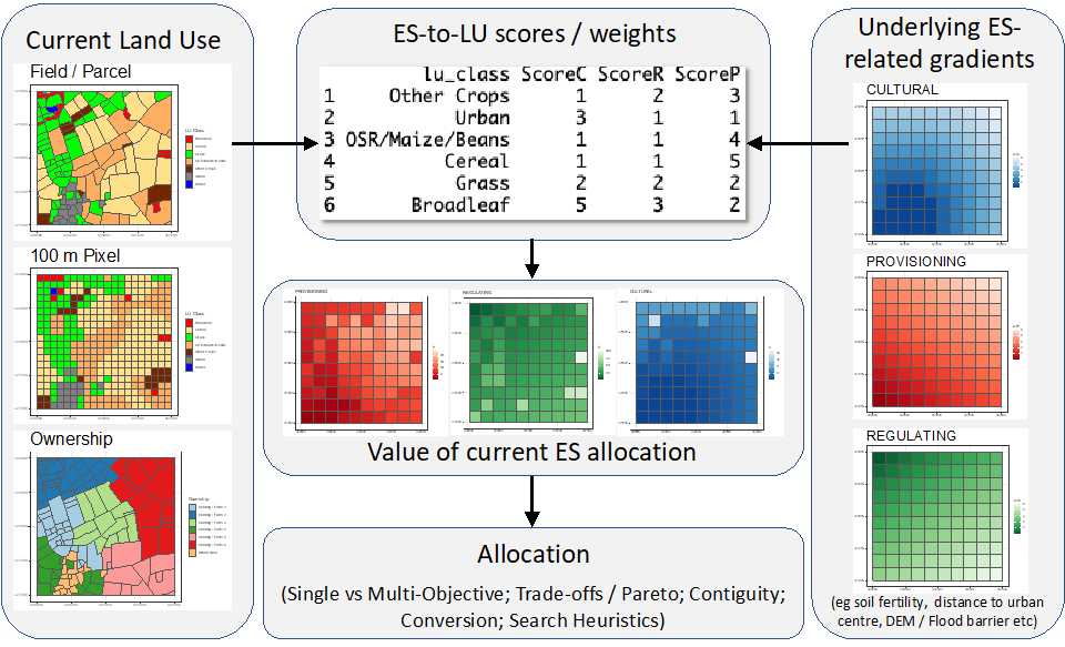
Figure 1. An example of the land use optimisation process: values are placed on different ecosystem services (ESs), and these interact with underlying suitability to generate values to be optimised.

For this Special Issue, we invite papers focusing on any aspect of land use optimisation, and we particularly welcome contributions examining the following topics:

  • Informing land use decision making to support complex and interacting policy objectives;
  • Handling divergent and potentially contradictory land use decision-making objectives;
  • Developing methods for handling the inherent uncertainty in land use optimisation (from scales of representation to ES scoring and weighting in multiobjective evaluation functions);
  • Exploring the impacts of scale on optimisation, from spatial data with different granularities and scales to evaluations of the impact of the Ecological Fallacy or the modifiable areal unit problem (MAUP) (OpenShaw 1984) on aggregated data used in allocation;
  • Modelling future land use compositions in a changing world (e.g., related to market and climate);
  • Considering how to incorporate values for other aspects of the problem (e.g., contiguity, conversion costs, and spatial aspects into optimisations);
  • Supporting multiobjective and multiscale landscape decisions;
  • Determining whether (quick) “good enough” solutions can be used to replace (slow) optimal ones.

Submissions can be grounded in any area related to land use optimisation (from novel allocation methods to land use decision making), can examine different scales of the problem (from field to global), and can be focused on any of the related thematic areas (e.g., agriculture, food, biofuel, carbon sequestration, development, cultural ecosystem services, flood protection) as well as their interactions.

References

Openshaw S (1984) CATMOG 38: the modifiable areal unit problem. In: Norwich: geo-abstracts – see https://www.qmrg.org.uk/catmog/index.html

Prof. Dr. Alexis Comber

Guest Editor

Manuscript Submission Information

Manuscripts should be submitted online at www.mdpi.com by registering and logging in to this website. Once you are registered, click here to go to the submission form. Manuscripts can be submitted until the deadline. All submissions that pass pre-check are peer-reviewed. Accepted papers will be published continuously in the journal (as soon as accepted) and will be listed together on the special issue website. Research articles, review articles as well as short communications are invited. For planned papers, a title and short abstract (about 100 words) can be sent to the Editorial Office for announcement on this website.

Submitted manuscripts should not have been published previously, nor be under consideration for publication elsewhere (except conference proceedings papers). All manuscripts are thoroughly refereed through a single-blind peer-review process. A guide for authors and other relevant information for submission of manuscripts is available on the Instructions for Authors page. Land is an international peer-reviewed open access monthly journal published by MDPI.

Please visit the Instructions for Authors page before submitting a manuscript. The Article Processing Charge (APC) for publication in this open access journal is 2600 CHF (Swiss Francs). Submitted papers should be well formatted and use good English. Authors may use MDPI's English editing service prior to publication or during author revisions.

Published Papers (12 papers)

Order results
Result details
Select all
Export citation of selected articles as:

Research

Jump to: Review

19 pages, 2534 KiB  
Article
A New Spatial Criteria Method to Delimit Rural Settlements towards Boundaries Equity: Land Use Optimization for Decision Making in Galicia, NW Spain
by Vasco Barbosa, Inés Santé-Riveira, Rafael Crecente-Maseda, Carlos Díaz Redondo, Juan Porta Trinidad, Jorge Parapar López, Ramón Doallo Biempica and José Ambrósio Ferreira Neto
Land 2022, 11(6), 800; https://0-doi-org.brum.beds.ac.uk/10.3390/land11060800 - 28 May 2022
Cited by 4 | Viewed by 1832
Abstract
Rural settlements (RS) are a reality of rural areas. They consist of cluster of buildings and ways of life mainly associated with activities related to agriculture. As economic policies applied in rural development have evolved, the physical delimitation of rural areas has become [...] Read more.
Rural settlements (RS) are a reality of rural areas. They consist of cluster of buildings and ways of life mainly associated with activities related to agriculture. As economic policies applied in rural development have evolved, the physical delimitation of rural areas has become more important because such areas are recipients of financial support, which depends on an area’s characteristics. Thus, it is necessary to formulate a new spatial approach for RS delimitation. The objective of this study is to define spatial criteria for identification and delimitation of the RS to recognize the morphological context of each RS. With respect to methodology, RS in the community of Galicia, Northwestern Spain were studied, and factors for spatial characterization were defined according to experts’ evaluations. Subsequently, spatial restrictions and conditions were identified for the delimitation of boundaries. The criteria that this research proposes reveal numerically adjustable factors that can recognize and interpret the morphological characteristics of each RS, which is also evidenced by the results of RS delimitations. It can be concluded that the numerically defined criteria associated with a spatial operation allow the adaptation to the morphological characteristics of any RS, as well as spatial equity by recognizing the differentiation of building structures and land uses of each RS, rather unlike the criteria defined by the law. Full article
(This article belongs to the Special Issue Land Use Optimisation)
Show Figures

Figure 1

17 pages, 822 KiB  
Article
The Importance of Scale and the MAUP for Robust Ecosystem Service Evaluations and Landscape Decisions
by Alexis Comber and Paul Harris
Land 2022, 11(3), 399; https://0-doi-org.brum.beds.ac.uk/10.3390/land11030399 - 09 Mar 2022
Cited by 7 | Viewed by 2632
Abstract
Spatial data are used in many scientific domains including analyses of Ecosystem Services (ES) and Natural Capital (NC), with results used to inform planning and policy. However, the data spatial scale (or support) has a fundamental impact on analysis outputs and, thus, process [...] Read more.
Spatial data are used in many scientific domains including analyses of Ecosystem Services (ES) and Natural Capital (NC), with results used to inform planning and policy. However, the data spatial scale (or support) has a fundamental impact on analysis outputs and, thus, process understanding and inference. The Modifiable Areal Unit Problem (MAUP) describes the effects of scale on analyses of spatial data and outputs, but it has been ignored in much environmental research, including evaluations of land use with respect to ES and NC. This paper illustrates the MAUP through an ES optimisation problem. The results show that MAUP effects are unpredictable and nonlinear, with discontinuities specific to the spatial properties of the case study. Four key recommendations are as follows: (1) The MAUP should always be tested for in ES evaluations. This is commonly performed in socio-economic analyses. (2) Spatial aggregation scales should be matched to process granularity by identifying the aggregation scale at which processes are considered to be stable (stationary) with respect to variances, covariances, and other moments. (3) Aggregation scales should be evaluated along with the scale of decision making (e.g., agricultural field, farm holding, and catchment). (4) Researchers in ES and related disciplines should up-skill themselves in spatial analysis and core paradigms related to scale to overcome the scale blindness commonly found in much research. Full article
(This article belongs to the Special Issue Land Use Optimisation)
Show Figures

Figure 1

17 pages, 4113 KiB  
Article
Quantitative Identification of Rural Functions Based on Big Data: A Case Study of Dujiangyan Irrigation District in Chengdu
by Qidi Dong, Jun Cai, Linjia Wu, Di Li and Qibing Chen
Land 2022, 11(3), 386; https://0-doi-org.brum.beds.ac.uk/10.3390/land11030386 - 05 Mar 2022
Cited by 2 | Viewed by 1925
Abstract
Urbanization increases the scales of urban spaces and the sizes of their populations, causing the functions in cities and towns to be in short supply. This study carries out functional space identification on the Dujiangyan elite irrigation area based on remote sensing data [...] Read more.
Urbanization increases the scales of urban spaces and the sizes of their populations, causing the functions in cities and towns to be in short supply. This study carries out functional space identification on the Dujiangyan elite irrigation area based on remote sensing data and point of interest (POI) data from Open Street Map (OSM), enabling the use of POI data to analyze rural functional spaces. Research and development and big data can greatly improve the accuracy of spatial function recognition, but research on rural spaces has limitations regarding the amount of available data. The Dujiangyan Irrigation District has low spatial aggregation levels for functions, scattered functions and linear distributions along roads. The mixing degrees of regional functions are low, the connections between functional elements are insufficient, and the comprehensive functional quality is low. The features of various functional elements in the region are significant, mostly in the discrete distribution mode, and functional compounding has become a trend. Therefore, it is necessary to integrate spatial resources and improve the centrality of cities and towns to realize the optimal allocation of resources and enable the development of surrounding cities and towns. Full article
(This article belongs to the Special Issue Land Use Optimisation)
Show Figures

Figure 1

20 pages, 37818 KiB  
Article
Catchment-Scale Participatory Mapping Identifies Stakeholder Perceptions of Land and Water Management Conflicts
by Kathleen C. Stosch, Richard S. Quilliam, Nils Bunnefeld and David M. Oliver
Land 2022, 11(2), 300; https://0-doi-org.brum.beds.ac.uk/10.3390/land11020300 - 16 Feb 2022
Cited by 4 | Viewed by 2522
Abstract
Competing socioecological demands and pressures on land and water resources have the potential to increase land use conflict. Understanding ecosystem service provisioning and trade-offs, competing land uses, and conflict between stakeholder groups in catchments is therefore critical to inform catchment management and the [...] Read more.
Competing socioecological demands and pressures on land and water resources have the potential to increase land use conflict. Understanding ecosystem service provisioning and trade-offs, competing land uses, and conflict between stakeholder groups in catchments is therefore critical to inform catchment management and the sustainable use of natural resources. We developed a novel stakeholder engagement methodology that incorporates participatory conflict mapping in three catchments with a short questionnaire to identify the perceptions of 43 participants from four key land and water management stakeholder groups: environmental regulators, water industry practitioners, the farm advisor community, and academics. The participatory mapping exercise produced heat maps of perceived conflict and land use competition, providing spatial detail of the complex combination of land use issues faced by catchment managers. Distinct, localised hotspots were identified in areas under pressure from flooding, abstraction, and urbanisation; as well as more dispersed issues of relevance at the landscape scale, such as from farming, forestry, energy production, and tourism. Subsequent regression modelling linked perceived conflict to land cover maps and identified coastal, urban, and grassland areas as the most likely land cover types associated with conflict in the study catchments. Our approach to participatory conflict mapping provides a novel platform for catchment management and can facilitate increased cooperation among different catchment stakeholders. In turn, land and water management conflicts can be recognised and their underlying drivers and likely solutions identified in an effort to better manage competing demands on catchment resources. Full article
(This article belongs to the Special Issue Land Use Optimisation)
Show Figures

Figure 1

41 pages, 44487 KiB  
Article
Optimizing Land Use and Land Cover Allocation for Flood Mitigation Using Land Use Change and Hydrological Models with Goal Programming, Chaiyaphum, Thailand
by Athiwat Phinyoyang and Suwit Ongsomwang
Land 2021, 10(12), 1317; https://0-doi-org.brum.beds.ac.uk/10.3390/land10121317 - 30 Nov 2021
Cited by 5 | Viewed by 2065
Abstract
Floods represent one of the most severe natural disasters threatening the development of human society worldwide, including in Thailand. In recent decades, Chaiyaphum province has experienced a problem with flooding almost every year. In particular, the flood in 2010 caused property damage of [...] Read more.
Floods represent one of the most severe natural disasters threatening the development of human society worldwide, including in Thailand. In recent decades, Chaiyaphum province has experienced a problem with flooding almost every year. In particular, the flood in 2010 caused property damage of 495 million Baht, more than 322,000 persons were affected, and approximately 1046.4 km2 of productive agricultural area was affected. Therefore, this study examined how to optimize land use and land cover allocation for flood mitigation using land use change and hydrological models with optimization methods. This research aimed to allocate land use and land cover (LULC) to minimize the surface for flood mitigation in Mueang Chaiyaphum district, Chaiyaphum province, Thailand. The research methodology consisted of six stages: data collection and preparation, LULC classification, LULC prediction, surface runoff estimation, the optimization of LULC allocation for flood mitigation and mapping, and economic and ecosystem service value evaluation and change. According to the results of the optimization and mapping of suitable LULC allocation to minimize surface runoff for flood mitigation in dry, normal, and wet years using goal programming and the CLUE-S model, the suitable LULC allocation for flood mitigation in 2049 under a normal year could provide the highest future economic value and gain. In the meantime, the suitable LULC allocation for flood mitigation in 2049 under a drought year could provide the highest ecosystem service value and gain. Nevertheless, considering future economic and ecosystem service values and changes with surface runoff reduction, the most suitable LULC allocation for flood mitigation is a normal year. Consequently, it can be concluded that the derived results of this study can be used as primary information for flood mitigation project implementation. Additionally, the presented conceptual framework and research workflows can be used as a guideline for government agencies to examine other flood-prone areas for flood mitigation in Thailand. Full article
(This article belongs to the Special Issue Land Use Optimisation)
Show Figures

Figure 1

19 pages, 5599 KiB  
Article
Integrating Climate Change Adaptation and Mitigation into Land Use Optimization: A Case Study in Huailai County, China
by Ying Xu and Lei Yao
Land 2021, 10(12), 1297; https://0-doi-org.brum.beds.ac.uk/10.3390/land10121297 - 25 Nov 2021
Cited by 3 | Viewed by 2286
Abstract
Land use plays a crucial role in climate change adaptation and mitigation, as the reasonable design of land use distribution can positively impact these things. Therefore, research interest in climate change adaptation and mitigation strategies in land use and management has been growing. [...] Read more.
Land use plays a crucial role in climate change adaptation and mitigation, as the reasonable design of land use distribution can positively impact these things. Therefore, research interest in climate change adaptation and mitigation strategies in land use and management has been growing. However, the adaptation and mitigation strategies have been handled separately at different dimensions and spatial levels. In this study, we presented a modeling framework for land use optimization that integrates climate change adaptation and mitigation, developed the model, and then applied it to Huailai County, wherein environmental and socioeconomic conditions are sensitive to climate change. The regional land use optimization model was combined with a linear programming model and a modified cellular automata model. Subsequently, the climate change adaptation and mitigation constraints, including ecological water demand, spatial suitability, and carbon sequestration, were incorporated into the model. The results indicate that most regions in the study area could adapt to and mitigate climate change with a constant land use pattern, and the land use conversion region under different climate change scenarios was primarily located in the topography transition region. The optimization results also reveal trade-offs between climate change adaptation and mitigation that were manifested with an increase in carbon sequestration and ecological water demand accompanied by decreases in the net income of agricultural production. Thus, it is necessary to simultaneously incorporate climate change adaptation and mitigation into land use optimization and management, and the proposed model provides a feasible method to incorporate them and balance their trade-offs in land use pattern optimization at a regional scale. Full article
(This article belongs to the Special Issue Land Use Optimisation)
Show Figures

Figure 1

21 pages, 12252 KiB  
Article
Delineating Urban Functional Zones Using U-Net Deep Learning: Case Study of Kuancheng District, Changchun, China
by Yuewen Yang, Dongyan Wang, Zhuoran Yan and Shuwen Zhang
Land 2021, 10(11), 1266; https://0-doi-org.brum.beds.ac.uk/10.3390/land10111266 - 19 Nov 2021
Cited by 4 | Viewed by 2662
Abstract
Scientific functional zone planning is the key to achieving long-term development goals for cities. The rapid development of remote sensing technology allows for the identification of urban functional zones, which is important since they serve as basic spatial units for urban planning and [...] Read more.
Scientific functional zone planning is the key to achieving long-term development goals for cities. The rapid development of remote sensing technology allows for the identification of urban functional zones, which is important since they serve as basic spatial units for urban planning and functioning. The accuracy of three methods—kernel density estimation, term frequency-inverse document frequency, and deep learning—for detecting urban functional zones was investigated using the Gaode points of interest, high-resolution satellite images, and OpenStreetMap. Kuancheng District was divided into twenty-one functional types (five single functional types and twenty mixed ones). The results showed that an approach using deep learning had a higher accuracy than the other two methods for delineating four out of five functions (excluding the commercial function) when compared with a field survey. The field survey showed that Kuancheng District was progressing towards completing the goals of the Land-Use Plan of the Central City of Changchun (2011–2020). Based on these findings, we illustrate the feasibility of identifying urban functional areas and lay out a framework for transforming them. Our results can guide the adjustment of the urban spatial structure and provide a reference basis for the scientific and reasonable development of urban land-use planning. Full article
(This article belongs to the Special Issue Land Use Optimisation)
Show Figures

Figure 1

20 pages, 34498 KiB  
Article
Spatiotemporal Differentiation of Territorial Space Development Intensity and Its Habitat Quality Response in Northeast China
by Zhipeng Yang, Shijun Wang, Meng Guo, Junfeng Tian and Yingjie Zhang
Land 2021, 10(6), 573; https://0-doi-org.brum.beds.ac.uk/10.3390/land10060573 - 28 May 2021
Cited by 17 | Viewed by 3071
Abstract
Studying the spatiotemporal distribution characteristics of territorial space development intensity (TSDI) and its habitat quality (HQ) response is of substantial theoretical and practical significance to optimize regional development patterns and coordinate the relationship between territorial space development and eco-environmental protection. This study establishes [...] Read more.
Studying the spatiotemporal distribution characteristics of territorial space development intensity (TSDI) and its habitat quality (HQ) response is of substantial theoretical and practical significance to optimize regional development patterns and coordinate the relationship between territorial space development and eco-environmental protection. This study establishes a comprehensive assessment model across various aspects, including land, population, economy, and input, to assess the TSDI of each county in Northeast China. We used the Integrated Valuation of Ecosystem Services and Tradeoffs (InVEST) model to evaluate the HQ of each county and investigated the HQ response to TSDI. The results showed that the TSDI in Northeast China was high in the south and west, low in the north and east, and prominent in urban agglomeration areas, which increased between 2000 and 2015. The spatial pattern of HQ was low in the east and south, high in the west and north, and the HQ was degraded as a whole. Bivariate spatial autocorrelation analysis showed a significant negative spatial correlation between TSDI and HQ, and distinct patterns of local spatial agglomeration were identified. Our findings provide guidelines for territorial space planning and may offer a reference for the ecological civilization construction and the coordinated development of Northeast China. Full article
(This article belongs to the Special Issue Land Use Optimisation)
Show Figures

Figure 1

17 pages, 36052 KiB  
Article
How to Perceive the Trade-Off of Economic and Ecological Intensity of Land Use in a City? A Functional Zones-Based Case Study of Tangshan, China
by Wencang Shen, Jianjun Zhang, Xiangli Zhou, Shengnan Li and Xiaoli Geng
Land 2021, 10(6), 551; https://0-doi-org.brum.beds.ac.uk/10.3390/land10060551 - 22 May 2021
Cited by 5 | Viewed by 1824
Abstract
China, in a rapid urbanization process, is accompanied by the expansion of built-up land, population accumulation, and intensive land investment, while the improvement of the urban environment cannot keep up with the population and economic density growth. Therefore, the purpose of this paper [...] Read more.
China, in a rapid urbanization process, is accompanied by the expansion of built-up land, population accumulation, and intensive land investment, while the improvement of the urban environment cannot keep up with the population and economic density growth. Therefore, the purpose of this paper is to discuss the balance between urban land use economic intensity (built-up area density, population density, land price) and ecological intensity (the depth, breadth, and integration of ecological spaces) in Tangshan. From the perspective of functional zones (FZs), the trade-off of economic and ecological intensity of different types of land use is detailed from the evaluation system. Finally, this paper explores a common intensive development model for different FZs to reach both reasonable economic and ecological purposes in Tangshan. The upshot indicates that the economic and ecological intensity of all FZs in Tangshan follows an opposite spatial distribution, and different types of FZ own their characteristics. The Gini index and Theil index for measuring the typical FZ indicate the unbalanced state between ecological spaces and population in residential areas. To sum up, a resource-based city, such as Tangshan, in the rapid development stage of urbanization tends to pay more attention to economic output and neglect ecological benefits. Full article
(This article belongs to the Special Issue Land Use Optimisation)
Show Figures

Figure 1

18 pages, 4214 KiB  
Article
An Ecological Service System Based Study on Suburban Rural Landscape Multifunction
by Jie Zheng, Lisha Na, Binglin Liu, Tiantian Zhang and Hao Wang
Land 2021, 10(3), 232; https://0-doi-org.brum.beds.ac.uk/10.3390/land10030232 - 25 Feb 2021
Cited by 7 | Viewed by 2448
Abstract
Suburban rural landscape multifunction has received increasing attention from scholars due to its high demand and impact on main urban areas. However, few studies have been focused on suburban rural landscape multifunction because of data constraints. The present study quantified the four landscape [...] Read more.
Suburban rural landscape multifunction has received increasing attention from scholars due to its high demand and impact on main urban areas. However, few studies have been focused on suburban rural landscape multifunction because of data constraints. The present study quantified the four landscape services based on ecological service system, i.e., regulating function (RF), provision function (PF), culture function (CF), and support function (SF), determined the interaction through the Spearman correlation coefficient, and ultimately identified the landscape multifunction hotspots and dominant functions through overlay analysis. The result indicated that suburban rural communities have exhibited the characteristics of regional multifunction, and the landscape multifunction hotspots accounted for 64.2%; it should be particularly noted that, among single-function, dual-function, and multifunction hotspots, both support function, and culture function was dominant, while only one case was found in which the regulating function was dominant. Furthermore, all landscape functions other than SF-CF exhibited certain correlations. The study suggests that planning and management should be performed in future in combination with landscape multifunction to ensure the sustainable development of suburban rural communities. Full article
(This article belongs to the Special Issue Land Use Optimisation)
Show Figures

Graphical abstract

Review

Jump to: Research

21 pages, 36960 KiB  
Review
Review of Soil Salinity and Sodicity Challenges to Crop Production in the Lowland Irrigated Areas of Ethiopia and Its Management Strategies
by Ashenafi Worku Daba and Asad Sarwar Qureshi
Land 2021, 10(12), 1377; https://0-doi-org.brum.beds.ac.uk/10.3390/land10121377 - 13 Dec 2021
Cited by 15 | Viewed by 7103
Abstract
Ethiopia’s irrigated agriculture productivity has been threatened by severe salinity and sodicity problems which have resulted in significantly lower yields, food insecurity, and environmental degradation. The destructive effects of poor irrigation water management with the absence of drainage and anticipated future climate changes [...] Read more.
Ethiopia’s irrigated agriculture productivity has been threatened by severe salinity and sodicity problems which have resulted in significantly lower yields, food insecurity, and environmental degradation. The destructive effects of poor irrigation water management with the absence of drainage and anticipated future climate changes can accelerate the formation of salt-affected soil, potentially expanding the problem to currently unaffected regions. This paper synthesizes the available information on the causes, extent, and effects of salt-affected soils on soil and crop production and suggest chemical, biological, and physical reclamation and management approaches for tackling salinity and sodicity problems. The mitigation approaches (e.g., the addition of amendments, plantation of salt-tolerant crops, appropriate irrigation and drainage management, phytoremediation, and bioremediation) have successfully tackled soil salinity and sodicity problems in many parts of the world. These approaches have further improved the socioeconomic conditions of farming communities in salt-affected areas. The paper also discusses the effectiveness of these mitigation strategies under Ethiopian conditions. The policy interventions for reclamation of soil salinity and sodicity that indicates future research attention to restoring agricultural sustainability are also foci of this paper. Full article
(This article belongs to the Special Issue Land Use Optimisation)
Show Figures

Figure 1

21 pages, 4939 KiB  
Review
The Application of Genetic Algorithm in Land Use Optimization Research: A Review
by Xiaoe Ding, Minrui Zheng and Xinqi Zheng
Land 2021, 10(5), 526; https://0-doi-org.brum.beds.ac.uk/10.3390/land10050526 - 14 May 2021
Cited by 18 | Viewed by 3918
Abstract
Land use optimization (LUO) first considers which types of land use should exist in a certain area, and secondly, how to allocate these land use types to specific land grid units. As an intelligent global optimization search algorithm, the Genetic Algorithm (GA) has [...] Read more.
Land use optimization (LUO) first considers which types of land use should exist in a certain area, and secondly, how to allocate these land use types to specific land grid units. As an intelligent global optimization search algorithm, the Genetic Algorithm (GA) has been widely used in this field. However, there are no comprehensive reviews concerning the development process for the application of the Genetic Algorithm in land use optimization (GA-LUO). This article used a bibliometric analysis method to explore current state and development trends for GA-LUO from 1154 relevant documents published over the past 25 years from Web of Science. We also displayed a visualization network from the aspects of core authors, research institutions, and highly cited literature. The results show the following: (1) The countries that published the most articles are the United States and China, and the Chinese Academy of Sciences is the research institution that publishes the most articles. (2) The top 10 cited articles focused on describing how to build GA models for multi-objective LUO. (3) According to the number of keywords that appear for the first time in each time period, we divided the process of GA-LUO into four stages: the presentation and improvement of methods stage (1995–2004), the optimization stage (2005–2008), the hybrid application of multiple models stage (2009–2016), and the introduction of the latest method stage (after 2017). Furthermore, future research trends are mainly manifested in integrating together algorithms with GA and deepening existing research results. This review could help researchers know this research domain well and provide effective solutions for land use problems to ensure the sustainable use of land resources. Full article
(This article belongs to the Special Issue Land Use Optimisation)
Show Figures

Figure 1

Back to TopTop